Difference between revisions of "2012-11-04 32 -116"
From Geohashing
imported>LucasBrown |
imported>Jiml m (Result codes look right) |
||
| Line 10: | Line 10: | ||
== Participants == | == Participants == | ||
| − | [[User:LucasBrown|LucasBrown]] | + | |
| + | * [[User:LucasBrown|LucasBrown]] | ||
== Photos == | == Photos == | ||
| Line 21: | Line 22: | ||
== Achievements == | == Achievements == | ||
{{#vardefine:ribbonwidth|800px}} | {{#vardefine:ribbonwidth|800px}} | ||
| + | |||
| + | {{Land geohash | latitude = 32 | longitude = -116 | date = 2012-11-04 | name = LucasBrown}} | ||
{{Geotrash | latitude = 32 | longitude = -116 | date = 2012-11-04 | name = LucasBrown}} | {{Geotrash | latitude = 32 | longitude = -116 | date = 2012-11-04 | name = LucasBrown}} | ||
| − | + | ||
[[Category:Expeditions]] | [[Category:Expeditions]] | ||
[[Category:Expeditions with photos]] | [[Category:Expeditions with photos]] | ||
[[Category:Expedition without GPS]] | [[Category:Expedition without GPS]] | ||
[[Category:Coordinates reached]] | [[Category:Coordinates reached]] | ||
Revision as of 17:18, 2 June 2013
| Sun 4 Nov 2012 in 32,-116: 32.8422319, -116.7904151 geohashing.info google osm bing/os kml crox |
Location
A lot fenced in on three sides off Tavern Road in Alpine, CA
Participants
Photos
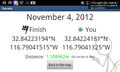
Geohash Droid details page at the hashpoint @32.8423,-116.7904
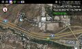
Map at the hashpoint @32.8423,-116.7904
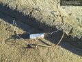
Geotrash @32.8420,-116.7868


Achievements
LucasBrown earned the Land geohash achievement
|
LucasBrown earned the GeoTrash Geohash Achievement
|