Difference between revisions of "2012-11-24 42 -89"
imported>Swensonj (→Plans) |
imported>FippeBot m (Location) |
||
| (10 intermediate revisions by 2 users not shown) | |||
| Line 1: | Line 1: | ||
| − | |||
| − | |||
| − | |||
| − | |||
| − | |||
| − | |||
| − | |||
| − | |||
| − | |||
| − | |||
{{meetup graticule | {{meetup graticule | ||
| lat=42 | | lat=42 | ||
| Line 18: | Line 8: | ||
__NOTOC__ | __NOTOC__ | ||
== Location == | == Location == | ||
| − | + | ||
| + | Maybe 100m south of the road in a field NW of Belleville, WI. | ||
== Participants == | == Participants == | ||
| − | [[User:swensonj|SwensonJ]] | + | [[User:swensonj|SwensonJ]] and his parents, wife, and kids |
== Plans == | == Plans == | ||
| Line 30: | Line 21: | ||
== Expedition == | == Expedition == | ||
| − | |||
| − | + | It was a bit cold today, but not windy or snowy, so good conditions for an XKCD meetup. I ([[User:swensonj|SwensonJ]]) hit the road with my parents, wife, and kids. This was the first exposure to geohashing for Mom and Dad; I haven't asked if this is the start of a new hobby for them. | |
| − | + | ||
| + | The hashpoint is not terribly far from the New Glarus Brewery, so we started by driving there for a tour. It was OK, but the plant doesn't operate on Saturdays, so the spectacle was kind of limited. We also hit the Duluth Trading Company outlet store in Belleville, WI, for a bit of bargain hunting. | ||
| + | |||
| + | From the store's parking lot, it was about a 10-minute drive to the hashpoint. On the way, we passed four sandhill cranes. We also saw quite a few Canada geese, and one field full of wild turkeys. We parked by an old schoolhouse, about 5 minutes after 4:00 p.m. It would have been a 100-yard walk downhill, but we had to park up the road a bit to get past the end of a barbed-wire fence. Still, it was quite a simple trip -- the rows of corn stubble even made it easier to keep going more or less due east to the hash point. We took the Stupid Grin photos, in every one of which my son stuck out his tongue without being noticed. | ||
| + | |||
| + | We hit the road by about 4:30, and headed north to the Duluth Trading Company store and the Grumpy Troll brewery in Mount Horeb, WI, so we finished the outing the same way we started it. | ||
== Photos == | == Photos == | ||
| Line 39: | Line 34: | ||
Image:2012-##-## ## ## Alpha.jpg | Witty Comment | Image:2012-##-## ## ## Alpha.jpg | Witty Comment | ||
--> | --> | ||
| − | <gallery perrow=" | + | <gallery perrow="4"> |
| + | Image:2012-11-24_42_-89 Brewery.jpg | We stopped at the New Glarus Brewery (New Glarus, Wisconsin) on the way to the hashpoint. | ||
| + | Image:2012-11-24_42_-89 Cranes.jpg | Four sandhill cranes stood by the road; two are seen here | ||
| + | Image:2012-11-24_42_-89 School.jpg | We parked across the road from this old stone schoolhouse | ||
| + | Image:2012-11-24_42_-89 Camera.jpg | SwensonJ is captured here taking... | ||
| + | Image:2012-11-24_42_-89 Proof.jpg | ... the GPS proof photo! | ||
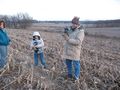
| + | Image:2012-11-24_42_-89 Family.jpg | Here's the family that was dragged along | ||
| + | Image:2012-11-24_42_-89 Moon.jpg | 4pm is sunset at latitude N42 | ||
| + | Image:2012-11-24_42_-89 Bart.jpg | We passed this surprising tree on the way home | ||
</gallery> | </gallery> | ||
== Achievements == | == Achievements == | ||
{{#vardefine:ribbonwidth|800px}} | {{#vardefine:ribbonwidth|800px}} | ||
| − | |||
| + | {{land geohash | ||
| − | + | | latitude = 42 | |
| − | + | | longitude = -89 | |
| − | + | | date = 2012-11-24 | |
| + | | name = SwensonJ | ||
| + | | image = 2012-11-24_42_-89 Proof.jpg | ||
| − | + | }} | |
| − | + | ||
| − | + | {{drag-along | |
| − | - | ||
| − | + | | latitude = 42 | |
| − | + | | longitude = -89 | |
| − | -- and | + | | date = 2012-11-24 |
| − | + | | partner = mom, dad, wife, and kids | |
| − | + | | name = SwensonJ | |
| − | + | | image = 2012-11-24_42_-89 Family.jpg | |
| − | |||
| − | |||
| − | |||
| − | |||
| + | }} | ||
| − | + | {{Regional geohashing | |
| − | |||
| − | |||
| − | |||
| − | |||
| − | |||
| − | |||
| − | |||
| − | + | | name = SwensonJ | |
| − | + | | region = Dane County, Wisconsin, U.S.A. | |
| − | + | | count = 2 | |
| − | + | }} | |
| − | |||
| − | + | [[Category:Expeditions]] | |
| + | [[Category:Expeditions with photos]] | ||
| + | [[Category:Coordinates reached]] | ||
| + | {{location|US|WI|DA}} | ||
Latest revision as of 06:59, 13 August 2019
| Sat 24 Nov 2012 in 42,-89: 42.8821370, -89.5743111 geohashing.info google osm bing/os kml crox |
Location
Maybe 100m south of the road in a field NW of Belleville, WI.
Participants
SwensonJ and his parents, wife, and kids
Plans
I hope to visit this hash after a quick trip to the New Glarus Brewery.
Not sure how long that visit will take, so I'm not sure if we'll make it for 4pm or not....
Expedition
It was a bit cold today, but not windy or snowy, so good conditions for an XKCD meetup. I (SwensonJ) hit the road with my parents, wife, and kids. This was the first exposure to geohashing for Mom and Dad; I haven't asked if this is the start of a new hobby for them.
The hashpoint is not terribly far from the New Glarus Brewery, so we started by driving there for a tour. It was OK, but the plant doesn't operate on Saturdays, so the spectacle was kind of limited. We also hit the Duluth Trading Company outlet store in Belleville, WI, for a bit of bargain hunting.
From the store's parking lot, it was about a 10-minute drive to the hashpoint. On the way, we passed four sandhill cranes. We also saw quite a few Canada geese, and one field full of wild turkeys. We parked by an old schoolhouse, about 5 minutes after 4:00 p.m. It would have been a 100-yard walk downhill, but we had to park up the road a bit to get past the end of a barbed-wire fence. Still, it was quite a simple trip -- the rows of corn stubble even made it easier to keep going more or less due east to the hash point. We took the Stupid Grin photos, in every one of which my son stuck out his tongue without being noticed.
We hit the road by about 4:30, and headed north to the Duluth Trading Company store and the Grumpy Troll brewery in Mount Horeb, WI, so we finished the outing the same way we started it.
Photos
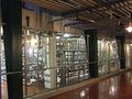
We stopped at the New Glarus Brewery (New Glarus, Wisconsin) on the way to the hashpoint.
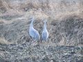
Four sandhill cranes stood by the road; two are seen here
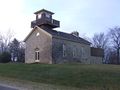
We parked across the road from this old stone schoolhouse
SwensonJ is captured here taking...
... the GPS proof photo!
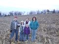
Here's the family that was dragged along
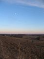
4pm is sunset at latitude N42
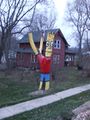
We passed this surprising tree on the way home


Achievements
SwensonJ earned the Land geohash achievement
|
SwensonJ earned the Drag-along achievement
|
SwensonJ earned the Regional geohashing achievement
|