Difference between revisions of "2012-12-05 33 -116"
From Geohashing
imported>LucasBrown (→Expedition) |
imported>FippeBot m (Location) |
||
| (7 intermediate revisions by 2 users not shown) | |||
| Line 7: | Line 7: | ||
== Participants == | == Participants == | ||
[[User:LucasBrown|LucasBrown]] | [[User:LucasBrown|LucasBrown]] | ||
| − | |||
| − | |||
| − | |||
| − | |||
| − | |||
| − | |||
| − | |||
| − | |||
| − | |||
| − | |||
== Photos == | == Photos == | ||
<gallery perrow="5"> | <gallery perrow="5"> | ||
| + | Image:2012-12-05_33_-116_10-44-59-608.jpg | Map at the hashpoint | ||
| + | Image:2012-12-05_33_-116_11-18-57-525.jpg | Zoomed-out map at the hashpoint [http://www.openstreetmap.org/?lat=33.09221050&lon=-116.99049549&zoom=16&layers=B000FTF @33.0922,-116.9905] | ||
| + | Image:2012-12-05_33_-116_12-48-32-298.jpg | The already-existing admission pass | ||
</gallery> | </gallery> | ||
== Achievements == | == Achievements == | ||
{{#vardefine:ribbonwidth|800px}} | {{#vardefine:ribbonwidth|800px}} | ||
| − | + | {{Restricted area | latitude = 33 | longitude = -116 | date = 2012-12-05 | name = LucasBrown}} | |
| − | |||
| − | |||
| − | |||
| − | |||
| − | |||
| − | |||
| − | |||
| − | |||
| − | |||
| − | |||
| − | |||
[[Category:Expeditions]] | [[Category:Expeditions]] | ||
| − | |||
[[Category:Expeditions with photos]] | [[Category:Expeditions with photos]] | ||
| − | |||
| − | |||
| − | |||
| − | |||
| − | |||
[[Category:Coordinates reached]] | [[Category:Coordinates reached]] | ||
| − | + | {{location|US|CA|SD}} | |
| − | |||
| − | |||
| − | |||
| − | |||
| − | |||
| − | |||
| − | |||
| − | |||
| − | |||
| − | |||
| − | |||
| − | |||
| − | |||
| − | |||
| − | |||
| − | |||
| − | |||
Latest revision as of 00:07, 14 August 2019
| Wed 5 Dec 2012 in 33,-116: 33.0914459, -116.9905048 geohashing.info google osm bing/os kml crox |
Location
Just off a tram route in the San Diego Zoo Safari Park
Participants
Photos
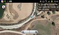
Map at the hashpoint
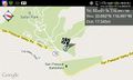
Zoomed-out map at the hashpoint @33.0922,-116.9905
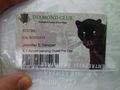
The already-existing admission pass


Achievements
LucasBrown earned the Restricted area achievement
|