Difference between revisions of "2012-12-08 42 -90"
From Geohashing
imported>Swensonj (initial data) |
imported>Swensonj (photos & ribbons) |
||
| Line 12: | Line 12: | ||
== Expedition == | == Expedition == | ||
| − | + | Success! Writeup to follow.... | |
== Photos == | == Photos == | ||
| − | |||
| − | |||
| − | |||
<gallery perrow="5"> | <gallery perrow="5"> | ||
| + | Image:2012-12-08_42_-90 Proof.jpg | We were really there! | ||
| + | Image:2012-12-08_42_-90 Kid.jpg | I took a picture of my daughter, up past her bedtime... | ||
| + | Image:2012-12-08_42_-90 Grin.jpg | And she took one of me. [You can tell that my hands were freezing.] | ||
| + | Image:2012-12-08_42_-90 Hash.jpg | The view would have been better in daylight. | ||
</gallery> | </gallery> | ||
| Line 25: | Line 26: | ||
{{#vardefine:ribbonwidth|800px}} | {{#vardefine:ribbonwidth|800px}} | ||
<!-- Add any achievement ribbons you earned below, or remove this section --> | <!-- Add any achievement ribbons you earned below, or remove this section --> | ||
| + | {{land geohash | ||
| + | | latitude = 42 | ||
| + | | longitude = -90 | ||
| + | | date = 2012-12-08 | ||
| + | | name = SwensonJ | ||
| + | | image = 2012-12-08_42_-90 Proof.jpg | ||
| + | }} | ||
| + | {{Regional geohashing | ||
| + | | name = SwensonJ | ||
| + | | region = Lafayette County, Wisconsin | ||
| + | | count = 2 | ||
| + | }} | ||
| − | |||
| − | |||
| − | |||
| − | |||
[[Category:Expeditions]] | [[Category:Expeditions]] | ||
| − | |||
[[Category:Expeditions with photos]] | [[Category:Expeditions with photos]] | ||
| − | |||
| − | |||
| − | |||
| − | |||
| − | |||
[[Category:Coordinates reached]] | [[Category:Coordinates reached]] | ||
| − | |||
| − | |||
| − | |||
| − | |||
| − | |||
| − | |||
| − | |||
| − | |||
| − | |||
| − | |||
| − | |||
| − | |||
| − | |||
| − | |||
| − | |||
| − | |||
| − | |||
| − | |||
Revision as of 04:04, 9 December 2012
| Sat 8 Dec 2012 in 42,-90: 42.5947867, -90.3675248 geohashing.info google osm bing/os kml crox |
Participants
Plans
Stopping by sometime: probably not at 4pm, though, because I'm planning to see the Nutcracker in Mineral Point. If successful, I'll finish the regional geohashing achievement for Lafayette County, Wisconsin.
Expedition
Success! Writeup to follow....
Photos
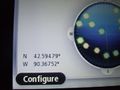
We were really there!
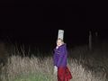
I took a picture of my daughter, up past her bedtime...
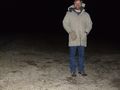
And she took one of me. [You can tell that my hands were freezing.]
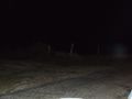
The view would have been better in daylight.


Achievements
SwensonJ earned the Land geohash achievement
|
SwensonJ earned the Regional geohashing achievement
|