Difference between revisions of "2012-12-12 47 -122"
imported>Thomcat ([live] Beer at the pub first, then geohash.) |
imported>FippeBot m (Location) |
||
| (4 intermediate revisions by one other user not shown) | |||
| Line 1: | Line 1: | ||
| − | |||
| − | |||
| − | |||
| − | |||
| − | |||
| − | |||
| − | |||
| − | |||
| − | |||
| − | |||
{{meetup graticule | {{meetup graticule | ||
| lat=47 | | lat=47 | ||
| lon=-122 | | lon=-122 | ||
| date=2012-12-12 | | date=2012-12-12 | ||
| + | | graticule_name=Seattle | ||
| + | | graticule_link=Seattle, Washington | ||
}} | }} | ||
| − | |||
__NOTOC__ | __NOTOC__ | ||
== Location == | == Location == | ||
| − | + | At the edge of an outbuilding in Edgewood. | |
== Participants == | == Participants == | ||
| − | + | * [[User:Thomcat|Thomcat]] | |
| − | |||
| − | |||
| − | |||
| − | |||
== Expedition == | == Expedition == | ||
| − | + | A month and a half is '''far''' too long for the Seattle graticule to go without a geohash. To be fair, most of those would have required military clearance or water wings. | |
| + | Wednesday night I was headed to Tacoma to have a pint with a pal and saw that the Geohash was likely to be achievable. Expedition! | ||
*Beer at the pub first, then geohash. -- [[User:Thomcat|Thomcat]] [http://www.openstreetmap.org/?lat=47.26189189&lon=-122.44612337&zoom=16&layers=B000FTF @47.2619,-122.4461] 18:59, 12 December 2012 (PST) | *Beer at the pub first, then geohash. -- [[User:Thomcat|Thomcat]] [http://www.openstreetmap.org/?lat=47.26189189&lon=-122.44612337&zoom=16&layers=B000FTF @47.2619,-122.4461] 18:59, 12 December 2012 (PST) | ||
| − | == | + | |
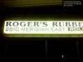
| − | + | After the pint, I drove to the spot, parking right beside the closed business. Mostly dark, with the only illumination from the very bright sign. | |
| + | |||
| + | *It's weird to sit watching the geohashdroid and see the dot - not the map - move. -- [[User:Thomcat|Thomcat]] [http://www.openstreetmap.org/?lat=47.23159795&lon=-122.29449628&zoom=16&layers=B000FTF @47.2316,-122.2945] 20:43, 12 December 2012 (PST) | ||
| + | |||
| + | This was the strange bit - I was parked, and the map was not moving a bit, but the dot actually slid around a little on the screen. Was it moving out of the way of the arrow? No idea. Anyhow, the closest I could get a reading was 5.5 meters, and on geohashdroid that ended up green - I am guessing due to the metal building and rain. The actual spot was (according to the photo) inside that building, which was not accessible after hours anyhow. | ||
| + | |||
| + | 12-12-12 geohash achieved! | ||
== Photos == | == Photos == | ||
| − | |||
| − | |||
| − | |||
<gallery perrow="5"> | <gallery perrow="5"> | ||
| − | |||
| − | == | + | Image:2012-12-12_47_-122_20-48-17-457.jpg | The building [http://www.openstreetmap.org/?lat=47.23159801&lon=-122.29452720&zoom=16&layers=B000FTF @47.2316,-122.2945] |
| − | |||
| − | |||
| + | Image:2012-12-12_47_-122_20-51-14-204.jpg | Time to head north again. [http://www.openstreetmap.org/?lat=47.23158744&lon=-122.29446060&zoom=16&layers=B000FTF @47.2316,-122.2945] | ||
| + | </gallery> | ||
| − | |||
| − | |||
| − | |||
| − | |||
| − | |||
| − | |||
| − | |||
| − | |||
| − | |||
| − | |||
[[Category:Expeditions]] | [[Category:Expeditions]] | ||
| − | |||
[[Category:Expeditions with photos]] | [[Category:Expeditions with photos]] | ||
| − | |||
| − | |||
| − | |||
| − | |||
| − | |||
[[Category:Coordinates reached]] | [[Category:Coordinates reached]] | ||
| − | + | {{location|US|WA|PI}} | |
| − | |||
| − | |||
| − | |||
| − | |||
| − | |||
| − | |||
| − | |||
| − | |||
| − | |||
| − | |||
| − | |||
| − | |||
| − | |||
| − | |||
| − | |||
| − | |||
| − | |||
Latest revision as of 00:12, 14 August 2019
| Wed 12 Dec 2012 in Seattle: 47.2316550, -122.2945172 geohashing.info google osm bing/os kml crox |
Location
At the edge of an outbuilding in Edgewood.
Participants
Expedition
A month and a half is far too long for the Seattle graticule to go without a geohash. To be fair, most of those would have required military clearance or water wings.
Wednesday night I was headed to Tacoma to have a pint with a pal and saw that the Geohash was likely to be achievable. Expedition!
- Beer at the pub first, then geohash. -- Thomcat @47.2619,-122.4461 18:59, 12 December 2012 (PST)
After the pint, I drove to the spot, parking right beside the closed business. Mostly dark, with the only illumination from the very bright sign.
- It's weird to sit watching the geohashdroid and see the dot - not the map - move. -- Thomcat @47.2316,-122.2945 20:43, 12 December 2012 (PST)
This was the strange bit - I was parked, and the map was not moving a bit, but the dot actually slid around a little on the screen. Was it moving out of the way of the arrow? No idea. Anyhow, the closest I could get a reading was 5.5 meters, and on geohashdroid that ended up green - I am guessing due to the metal building and rain. The actual spot was (according to the photo) inside that building, which was not accessible after hours anyhow.
12-12-12 geohash achieved!
Photos
The building @47.2316,-122.2945

Time to head north again. @47.2316,-122.2945

