Difference between revisions of "2012-12-14 32 34"
imported>LiNaK |
m (per Renaming Proposal) |
||
| (12 intermediate revisions by 2 users not shown) | |||
| Line 30: | Line 30: | ||
Anyway, after packing some snacks I've left home towards Yehud and leaving the city from it's other side to Magshimim and the other agricultural communities that are spread east to it between fields and plantations of different sorts: Be'erot Yitshak, Nofech and Mazor. Turns out that unlike my parents' concerns, the more dangerous part wasn't biking near the main roads but the raid inside the villages- no one here thinks he needs to have their dogs kept at their personal backyards, and that would have been fine if the dogs weren't so territorial and aggressive. A countless amount of dogs chased me along parts of the way, some nearly knocking me off the bikes (though to be fair, that happened mostly in Nofech, and there probably because I had some navigation mistakes and turns out I should have biked straight along the village's main road instead of through it's side roads like it seems I have). | Anyway, after packing some snacks I've left home towards Yehud and leaving the city from it's other side to Magshimim and the other agricultural communities that are spread east to it between fields and plantations of different sorts: Be'erot Yitshak, Nofech and Mazor. Turns out that unlike my parents' concerns, the more dangerous part wasn't biking near the main roads but the raid inside the villages- no one here thinks he needs to have their dogs kept at their personal backyards, and that would have been fine if the dogs weren't so territorial and aggressive. A countless amount of dogs chased me along parts of the way, some nearly knocking me off the bikes (though to be fair, that happened mostly in Nofech, and there probably because I had some navigation mistakes and turns out I should have biked straight along the village's main road instead of through it's side roads like it seems I have). | ||
| − | After a very nice and calm raid in a weather that was optimal for biking (a few raindrops along the way were kind enough not to develop to actual rain), I crossed a rail line and changed ,my scenery to orchards and roads that were a little muddier than I expected (but it could have been much worse), had a small stop for pecans and a granola bar and than joined the Cross-Israel Hiking Trail and the bridge above Highway 6. A little more biking along the highway from it's other side and I was finally in El'ad. | + | After a very nice and calm raid in a weather that was optimal for biking (a few raindrops along the way were kind enough not to develop to actual rain), I crossed a rail line and changed ,my scenery to orchards and roads that were a little muddier than I expected (but it could have been much worse), had a small stop for pecans and a granola bar and than joined the Cross-Israel Hiking Trail and the bridge above Highway 6. A little more biking along the highway from it's other side, olive groves and I was finally in El'ad. |
| − | El'ad is a very orthodox, religious city, the kind where people gave surprised looks at me because the sight of a teenager with long hair and clothing that isn't just black and white is unusual by itself, even before he starts walking slowly with his eyes on his phone looking for a specific point that had nothing special in it and than taking pictures of the place. It's also built on a hill side so the last push before the hashpoint was a steep climb. And just to stay on the safe side, I kept my bicycle helmet on instead of a Yarmulke (I told myself to bring one last night, but forgot this morning). The hashpoint itself was in an inner yard between a few buildings and while I was looking for the exact spot a group of about eight little kids gathered around me (I think they were all brothers and sisters, but I'm not sure), and one asked me where am I going, to which I gave some hasty answer and quickly left the area before they will ask some additional questions. (Gash, my peoples skills are so rubbish sometimes. Why does talking with little kids have to panic me? I should have been super nice to them and have fun with some [[Cover Stories|cover stories]] instead. | + | El'ad is a very orthodox, religious city, the kind where people gave surprised looks at me because the sight of a teenager with long hair and clothing that isn't just black and white is unusual by itself, even before he starts walking slowly with his eyes on his phone looking for a specific point that had nothing special in it and than taking pictures of the place. It's also built on a hill side so the last push before the hashpoint was a steep climb. And just to stay on the safe side, I kept my bicycle helmet on instead of a Yarmulke (I told myself to bring one last night, but forgot this morning). The hashpoint itself was in an inner yard between a few buildings and while I was looking for the exact spot a group of about eight little kids gathered around me (I think they were all brothers and sisters, but I'm not sure), and one asked me where am I going, to which I gave some hasty answer and quickly left the area before they will ask some additional questions. (Gash, my peoples skills are so rubbish sometimes. Why does talking with little kids have to panic me? I should have been super nice to them and have fun with some [[Cover Stories|cover stories]] instead. Oh well, maybe next time I'll get over my fear of strangers.) |
| − | + | And than there was the way back, with a small stop in the olive grove for some more pecans and than deciding I'm still hungry but can't eat any more of these, getting chased by some more dogs and before I knew it I was back at the familiar streets of Yehud and at home for a lunch that was something other than pecans. | |
| − | + | ||
| + | Overall that had been a great, though a little tiring geohash. Gave me an opportunity to see an area that is very close to my home from an unusual viewing point, meet a city and people that I don't usually meet and gain another experience to my growing list of hashes. According to Google maps, that was about 30 KM in an expedition that took three and a half hours. | ||
== Photos == | == Photos == | ||
| Line 42: | Line 43: | ||
--> | --> | ||
<gallery perrow="5"> | <gallery perrow="5"> | ||
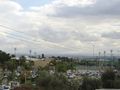
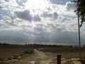
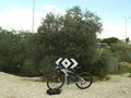
| + | Image:2012 12 14 32 34 hills.jpg | See the hills at the back? That's where we're headed. | ||
| + | Image:2012 12 14 32 34 hills2.jpg | Yes, thee hills over there... | ||
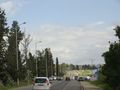
| + | Image:2012 12 14 32 34 way.jpg | The way is still long | ||
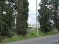
| + | Image:2012 12 14 32 34 countryside.jpg | It's great to visit the countryside sometimes, even if it smells like cow manure this season. | ||
| + | Image:2012 12 14 32 34 lost.jpg | I've wasted some time surrounding Nofech for no reason. | ||
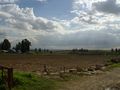
| + | Image:2012 12 14 32 34 field.jpg | At Mazor. | ||
| + | Image:2012 12 14 32 34 train.jpg | I love trains! | ||
| + | Image:2012 12 14 32 34 elad.jpg | You can already see El'ad. | ||
| + | Image:2012 12 14 32 34 plant.jpg | Some plantations. | ||
| + | Image:2012 12 14 32 34 orchard.jpg | Orchard. | ||
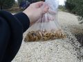
| + | Image:2012 12 14 32 34 tuna.jpg | Tunas (the fruit, not the fish) are delicious. | ||
| + | Image:2012 12 14 32 34 tuna2.jpg | With a tin can and some experience you can pick the fruit without getting hurt- I had neither. | ||
| + | Image:2012 12 14 32 34 mud.jpg | The way wasn't as dry as I wanted it to be, but it could be much worse. | ||
| + | Image:2012 12 14 32 34 stop.jpg | Stopped for a snack. | ||
| + | Image:2012 12 14 32 34 israel.jpg | Orange, blue and white: the Cross-Israel Trail. | ||
| + | Image:2012 12 14 32 34 6.jpg | Highway 6- to the south. | ||
| + | Image:2012 12 14 32 34 62.jpg | Highway 6- to the north. | ||
| + | Image:2012 12 14 32 34 olive.jpg | Olive groves. | ||
| + | Image:2012 12 14 32 34 elad2.jpg | In El'ad. | ||
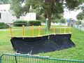
| + | Image:2012 12 14 32 34 art.jpg | Don't ask me, it was like that when I arrived. | ||
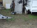
| + | Image:2012 12 14 32 34 zero.jpg | Seriously, did a missile land here? | ||
| + | Image:2012 12 14 32 34 zero2.jpg | It didn't seem like that on the satellite image. | ||
| + | Image:2012 12 14 32 34 hash.jpg | The hashpoint (these are the kids I was talking about) | ||
| + | Image:2012 12 14 32 34 side.jpg | To the other side | ||
| + | Image:2012 12 14 32 34 stop2.jpg | A stop in the olive grove. | ||
| + | Image:2012 12 14 32 34 pecans.jpg | A snack for the ride. | ||
| + | Image:2012 12 14 32 34 duck.jpg | You're a duck! | ||
| + | Image:2012 12 14 32 34 hanukkah.jpg | Happy Hanukkah! (or any other holiday) | ||
</gallery> | </gallery> | ||
== Achievements == | == Achievements == | ||
{{#vardefine:ribbonwidth|800px}} | {{#vardefine:ribbonwidth|800px}} | ||
| − | + | {{Graticule unlocked | |
| + | | latitude = 32 | ||
| + | | longitude = 34 | ||
| + | | date = 2012-12-14 | ||
| + | | name = [[User:LiNaK|LinaK]] | ||
| + | | image = 2012 12 14 32 34 hash.jpg | ||
| + | }} | ||
| + | |||
| + | |||
| + | {{bicycle geohash | ||
| + | | latitude = 32 | ||
| + | | longitude = 34 | ||
| + | | date = 2012-12-14 | ||
| + | | name = [[User:LiNaK|LinaK]] | ||
| + | | distance = 30 KM | ||
| + | | bothways = true | ||
| + | | image = 2012 12 14 32 34 stop.jpg | ||
| + | }} | ||
<!-- =============== USEFUL CATEGORIES FOLLOW ================ | <!-- =============== USEFUL CATEGORIES FOLLOW ================ | ||
Delete the next line ONLY if you have chosen the appropriate categories below. If you are unsure, don't worry. People will read your report and help you with the classification. --> | Delete the next line ONLY if you have chosen the appropriate categories below. If you are unsure, don't worry. People will read your report and help you with the classification. --> | ||
| − | |||
| − | |||
| − | |||
| − | |||
| − | |||
| − | |||
| − | |||
[[Category:Expeditions]] | [[Category:Expeditions]] | ||
| − | + | [[Category:Expeditions with photos]] | |
| − | [[Category:Expeditions with photos]] | ||
| − | |||
| − | |||
| − | |||
| − | |||
| − | |||
[[Category:Coordinates reached]] | [[Category:Coordinates reached]] | ||
| − | + | {{location|IL|M|PT}} | |
| − | |||
| − | |||
| − | |||
| − | |||
| − | |||
| − | |||
| − | |||
| − | |||
| − | |||
| − | |||
| − | |||
| − | |||
| − | |||
| − | |||
| − | |||
| − | |||
| − | |||
Latest revision as of 05:29, 20 March 2024
| Fri 14 Dec 2012 in 32,34: 32.0489428, 34.9548135 geohashing.info google osm bing/os kml crox |
Location
Behind a primary school, "Graceful Torah", in El'ad, Rabbi Akiva Street on Raban Yohanan ben Zakai Street (guess what religion do they practice there?).
Participants
Omri (LinaK)
Plans
Bike from Monoson through Yehud, and than along the villages between highways 40 and 6, meet the Cross-Israel Hiking Trail and follow it to El'ad.
Expedition
Drawing conclusions from the last few hashes, I've given up on trying to use my old GPS device. Turns out my mom's phone has one of it's own so I've taken her's and had a much easier time now that GPS readings weren't dependent on the good will of a nine years old device. These new smartphones have everything in them, maybe I need to get one for myself...
Anyway, after packing some snacks I've left home towards Yehud and leaving the city from it's other side to Magshimim and the other agricultural communities that are spread east to it between fields and plantations of different sorts: Be'erot Yitshak, Nofech and Mazor. Turns out that unlike my parents' concerns, the more dangerous part wasn't biking near the main roads but the raid inside the villages- no one here thinks he needs to have their dogs kept at their personal backyards, and that would have been fine if the dogs weren't so territorial and aggressive. A countless amount of dogs chased me along parts of the way, some nearly knocking me off the bikes (though to be fair, that happened mostly in Nofech, and there probably because I had some navigation mistakes and turns out I should have biked straight along the village's main road instead of through it's side roads like it seems I have).
After a very nice and calm raid in a weather that was optimal for biking (a few raindrops along the way were kind enough not to develop to actual rain), I crossed a rail line and changed ,my scenery to orchards and roads that were a little muddier than I expected (but it could have been much worse), had a small stop for pecans and a granola bar and than joined the Cross-Israel Hiking Trail and the bridge above Highway 6. A little more biking along the highway from it's other side, olive groves and I was finally in El'ad.
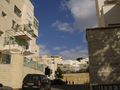
El'ad is a very orthodox, religious city, the kind where people gave surprised looks at me because the sight of a teenager with long hair and clothing that isn't just black and white is unusual by itself, even before he starts walking slowly with his eyes on his phone looking for a specific point that had nothing special in it and than taking pictures of the place. It's also built on a hill side so the last push before the hashpoint was a steep climb. And just to stay on the safe side, I kept my bicycle helmet on instead of a Yarmulke (I told myself to bring one last night, but forgot this morning). The hashpoint itself was in an inner yard between a few buildings and while I was looking for the exact spot a group of about eight little kids gathered around me (I think they were all brothers and sisters, but I'm not sure), and one asked me where am I going, to which I gave some hasty answer and quickly left the area before they will ask some additional questions. (Gash, my peoples skills are so rubbish sometimes. Why does talking with little kids have to panic me? I should have been super nice to them and have fun with some cover stories instead. Oh well, maybe next time I'll get over my fear of strangers.)
And than there was the way back, with a small stop in the olive grove for some more pecans and than deciding I'm still hungry but can't eat any more of these, getting chased by some more dogs and before I knew it I was back at the familiar streets of Yehud and at home for a lunch that was something other than pecans.
Overall that had been a great, though a little tiring geohash. Gave me an opportunity to see an area that is very close to my home from an unusual viewing point, meet a city and people that I don't usually meet and gain another experience to my growing list of hashes. According to Google maps, that was about 30 KM in an expedition that took three and a half hours.
Photos
See the hills at the back? That's where we're headed.
Yes, thee hills over there...
The way is still long
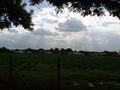
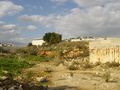
It's great to visit the countryside sometimes, even if it smells like cow manure this season.
I've wasted some time surrounding Nofech for no reason.
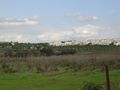
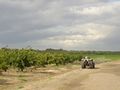
At Mazor.
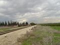
I love trains!
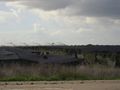
You can already see El'ad.
Some plantations.
Orchard.
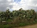
Tunas (the fruit, not the fish) are delicious.
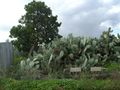
With a tin can and some experience you can pick the fruit without getting hurt- I had neither.
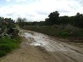
The way wasn't as dry as I wanted it to be, but it could be much worse.
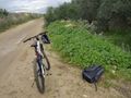
Stopped for a snack.
Orange, blue and white: the Cross-Israel Trail.
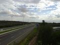
Highway 6- to the south.
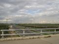
Highway 6- to the north.
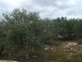
Olive groves.
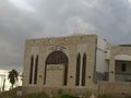
In El'ad.
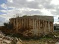
Don't ask me, it was like that when I arrived.
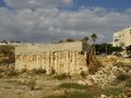
Seriously, did a missile land here?
It didn't seem like that on the satellite image.
The hashpoint (these are the kids I was talking about)
To the other side
A stop in the olive grove.
A snack for the ride.
You're a duck!
Happy Hanukkah! (or any other holiday)


Achievements
LinaK earned the Graticule Unlocked Achievement
|
LinaK earned the Bicycle geohash achievement
|