Difference between revisions of "2012-12-17 33 -117"
From Geohashing
imported>LucasBrown |
m |
||
| (6 intermediate revisions by 3 users not shown) | |||
| Line 7: | Line 7: | ||
== Participants == | == Participants == | ||
[[User:LucasBrown|LucasBrown]] | [[User:LucasBrown|LucasBrown]] | ||
| − | |||
| − | |||
| − | |||
== Photos == | == Photos == | ||
<gallery perrow="5"> | <gallery perrow="5"> | ||
| + | Image:2012-12-17_33_-117_15-58-24-937.jpg | Geohash Droid details page at the hashpoint | ||
| + | Image:2012-12-17_33_-117_15-59-48-457.jpg | Map at the hashpoint | ||
</gallery> | </gallery> | ||
== Achievements == | == Achievements == | ||
{{#vardefine:ribbonwidth|800px}} | {{#vardefine:ribbonwidth|800px}} | ||
| − | + | {{Speed racer | latitude = 33 | longitude = -117 | date = 2012-12-17 | name = LucasBrown}} | |
| − | |||
| − | |||
| − | |||
[[Category:Expeditions]] | [[Category:Expeditions]] | ||
| + | [[Category:Coordinates reached]] | ||
[[Category:Expeditions with photos]] | [[Category:Expeditions with photos]] | ||
| − | + | {{location|US|CA|SD}} | |
| − | |||
Latest revision as of 19:30, 11 September 2021
| Mon 17 Dec 2012 in 33,-117: 33.0922359, -117.0807623 geohashing.info google osm bing/os kml crox |
Location
West Citracado Parkway, between I-15 and Miller Avenue, Escondido, CA
Participants
Photos
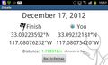
Geohash Droid details page at the hashpoint
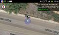
Map at the hashpoint


Achievements

LucasBrown earned the Speed racer achievement
by passing through the (33, -117) geohash on 2012-12-17 at the maximum legal speed.