2012-12-20 61 23
From Geohashing
Revision as of 07:20, 20 December 2012 by imported>Teukkam ([live picture] Even more impressive ice falls [http://www.openstreetmap.org/?lat=61.63100000&lon=23.53350000&zoom=16&layers=B000FTF @61.6310,23.5335])
| Thu 20 Dec 2012 in 61,23: 61.6308743, 23.5324032 geohashing.info google osm bing/os kml crox |
Location
Viljakkala, Ylöjärvi, near Särkijärvi.
Participants
Plans
National Survey topographic map shows some building near the hashpoint so it is likely to be on private property. But the road to the site is missing from OSM, so at the very least return with a GPS trace and add it to OSM for OpenStreetMap achievement. If the hash can be reached, the route could also barely qualify for Juggernaut achievement. We'll see...
Expedition
- Basically easily reachable from my work location. Could be private property though. -- TeukkaM 07:12, 20 December 2012 (EET)
Tracklog
Photos

A bit nippy @61.6328,23.5201
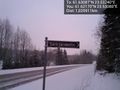
Proof of road name for OSM. @61.6217,23.5308
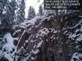
Some pretty impressive cliffs here @61.6317,23.5304
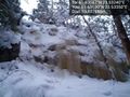
Even more impressive ice falls @61.6310,23.5335


Achievements