Difference between revisions of "2012-12-23 27 -80"
imported>DrCanadianNinja (Created page with "{{meetup graticule | map=<map lat="27" lon="-80" date="2012-12-23" /> | lat=27 | lon=-80 | date=2012-12-23 | graticule_name=Fort Pierce, Florida | graticule_link=Port St. Lucie, ...") |
m (per Renaming Proposal) |
||
| (5 intermediate revisions by 4 users not shown) | |||
| Line 5: | Line 5: | ||
| date=2012-12-23 | | date=2012-12-23 | ||
| graticule_name=Fort Pierce, Florida | | graticule_name=Fort Pierce, Florida | ||
| − | | graticule_link=Port St | + | | graticule_link=Port St Lucie, Florida}} |
==Expedition== | ==Expedition== | ||
| Line 13: | Line 13: | ||
=== The Geohashers === | === The Geohashers === | ||
| − | * [[user: | + | * [[user:Geoffistopheles|Geoff]] |
* Geoff's Dad | * Geoff's Dad | ||
=== The Adventure === | === The Adventure === | ||
| − | [[2012-12-23_27_- | + | [[2012-12-23_27_-81|From Sebring Regional]], we took to Fort Pierce. This was our original destination for lunch, but the two of us got hungry early and as it turned out, saved us a bit of time. Landing at Fort Pierce is a little more difficult due to being a higher traffic airport, plus the Tiki Hut there is pretty popular. Eating at a different place means we could get going a little faster. |
Unfortunately, that complicated matters in terms of geohashing. See, if the hash is approaching their airspace, we can hit the geohash and continue on to land. If we miss our opportunity, we can get it again. Now, however, we have to stay out. This adds another little issue; Fort Pierce isn't the only high traffic airport around. There's also Vero Beach Municipal Airport to the north, and the geohash was just before them. | Unfortunately, that complicated matters in terms of geohashing. See, if the hash is approaching their airspace, we can hit the geohash and continue on to land. If we miss our opportunity, we can get it again. Now, however, we have to stay out. This adds another little issue; Fort Pierce isn't the only high traffic airport around. There's also Vero Beach Municipal Airport to the north, and the geohash was just before them. | ||
| + | |||
| + | Also, to get there requires crossing a military bombing range, but at this point that's so pedestrian I feel like I just wasted your time. | ||
We reached the geohash and hit some turbulence, so the picture came out really blurry. We did a hard turn, then continued into a figure 8 for a slightly better picture. I didn't leave a playing card this time, mainly because there wasn't an airport we were landing at to leave it, and it seems like a waste to leave three in one location. We ended our eastern run to head south to [[2012-12-23_26_-80|Lake Okeechobee]]. | We reached the geohash and hit some turbulence, so the picture came out really blurry. We did a hard turn, then continued into a figure 8 for a slightly better picture. I didn't leave a playing card this time, mainly because there wasn't an airport we were landing at to leave it, and it seems like a waste to leave three in one location. We ended our eastern run to head south to [[2012-12-23_26_-80|Lake Okeechobee]]. | ||
== Gallery == | == Gallery == | ||
| − | + | <gallery caption="Photo Gallery" widths="200px" heights="200px" perrow="3"> | |
| + | Image:2012-12-23_27_-80_BombingRange.JPG|Ho hum, crossing a bombing range. | ||
| + | Image:2012-12-23_27_-80_Geohash.JPG|See the subcommunity in the distance? Follow the line of trees on the left back towards the camera: On the left of the trees is Indian River county, on the right is St. Lucie. The geohash is in the farmlands on the right. | ||
| + | Image:2012-12-23_27_-80_GPS.JPG|There was a less jerky picture, but this one had more accurate coordinates, so... sorry? | ||
| + | </gallery> | ||
== Achievables == | == Achievables == | ||
| Line 32: | Line 38: | ||
| longitude = -81 | | longitude = -81 | ||
| date = 2012-12-23 | | date = 2012-12-23 | ||
| − | | name = [[user: | + | | name = [[user:Geoffistopheles|Geoff]] |
| vehicle = Grumman American | | vehicle = Grumman American | ||
}} | }} | ||
| − | {{ | + | {{Graticule unlocked |
| latitude = 27 | | latitude = 27 | ||
| longitude = -80 | | longitude = -80 | ||
| date = 2012-12-23 | | date = 2012-12-23 | ||
| − | | name = [[user: | + | | name = [[user:Geoffistopheles|Geoff]] |
}} | }} | ||
| Line 48: | Line 54: | ||
[[Category:Expeditions with photos]] | [[Category:Expeditions with photos]] | ||
[[Category:Coordinates reached]] | [[Category:Coordinates reached]] | ||
| + | {{location|US|FL|IN}} | ||
Latest revision as of 05:28, 20 March 2024
| Sun 23 Dec 2012 in Fort Pierce, Florida: 27.5585921, -80.5100048 geohashing.info google osm bing/os kml crox |
Expedition
The Plan
Just south of the county line west of I-95.
The Geohashers
- Geoff
- Geoff's Dad
The Adventure
From Sebring Regional, we took to Fort Pierce. This was our original destination for lunch, but the two of us got hungry early and as it turned out, saved us a bit of time. Landing at Fort Pierce is a little more difficult due to being a higher traffic airport, plus the Tiki Hut there is pretty popular. Eating at a different place means we could get going a little faster.
Unfortunately, that complicated matters in terms of geohashing. See, if the hash is approaching their airspace, we can hit the geohash and continue on to land. If we miss our opportunity, we can get it again. Now, however, we have to stay out. This adds another little issue; Fort Pierce isn't the only high traffic airport around. There's also Vero Beach Municipal Airport to the north, and the geohash was just before them.
Also, to get there requires crossing a military bombing range, but at this point that's so pedestrian I feel like I just wasted your time.
We reached the geohash and hit some turbulence, so the picture came out really blurry. We did a hard turn, then continued into a figure 8 for a slightly better picture. I didn't leave a playing card this time, mainly because there wasn't an airport we were landing at to leave it, and it seems like a waste to leave three in one location. We ended our eastern run to head south to Lake Okeechobee.
Gallery
- Photo Gallery

Ho hum, crossing a bombing range.
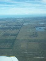
See the subcommunity in the distance? Follow the line of trees on the left back towards the camera: On the left of the trees is Indian River county, on the right is St. Lucie. The geohash is in the farmlands on the right.
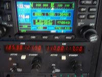
There was a less jerky picture, but this one had more accurate coordinates, so... sorry?


Achievables
Geoff earned the Air geohash achievement
|
Geoff earned the Graticule Unlocked Achievement
|