Difference between revisions of "2012-12-23 29 -82"
imported>Grumpa (→Expedition) |
imported>FippeBot m (Location) |
||
| (2 intermediate revisions by 2 users not shown) | |||
| Line 1: | Line 1: | ||
| − | |||
| − | |||
| − | |||
| − | |||
| − | |||
| − | |||
| − | |||
| − | |||
| − | |||
{{meetup graticule | {{meetup graticule | ||
| lat=29 | | lat=29 | ||
| Line 13: | Line 4: | ||
| date=2012-12-23 | | date=2012-12-23 | ||
}} | }} | ||
| − | |||
| − | |||
__NOTOC__ | __NOTOC__ | ||
== Location == | == Location == | ||
| Line 39: | Line 28: | ||
== Photos == | == Photos == | ||
| − | |||
<gallery perrow="5"> | <gallery perrow="5"> | ||
Image:2012-12-23_29_-82_01.jpg| Georgeous day for flying! | Image:2012-12-23_29_-82_01.jpg| Georgeous day for flying! | ||
| Line 48: | Line 36: | ||
Image:2012-12-23_29_-82_06.jpg| Oblique view of my two passes showing the relative elevation. Hashpoint labeled GNV. | Image:2012-12-23_29_-82_06.jpg| Oblique view of my two passes showing the relative elevation. Hashpoint labeled GNV. | ||
Image:2012-12-23_29_-82_07.jpg| Overhead view of the two passes. The whole bit out to the west, changing colors, is me climbing from 1300' to 5400'. The 360 over Archer was because I realized I wouldn't have the altitude for the Mile High. | Image:2012-12-23_29_-82_07.jpg| Overhead view of the two passes. The whole bit out to the west, changing colors, is me climbing from 1300' to 5400'. The 360 over Archer was because I realized I wouldn't have the altitude for the Mile High. | ||
| − | |||
</gallery> | </gallery> | ||
| Line 54: | Line 41: | ||
{{#vardefine:ribbonwidth|800px}} | {{#vardefine:ribbonwidth|800px}} | ||
<!-- Add any achievement ribbons you earned below, or remove this section --> | <!-- Add any achievement ribbons you earned below, or remove this section --> | ||
| + | {{air geohash | latitude = 29 | longitude = -82 | date = 2012-12-23 | name = Grumpa | vehicle = Cessna 172 }} | ||
| + | Mile High Award | ||
| − | |||
| − | |||
| − | |||
| − | |||
| − | |||
| − | |||
| − | |||
| − | |||
| − | |||
| − | |||
| − | |||
[[Category:Expeditions]] | [[Category:Expeditions]] | ||
| − | + | [[Category:Expeditions with photos]] | |
| − | [[Category:Expeditions with photos]] | ||
| − | |||
| − | |||
| − | |||
| − | |||
| − | |||
[[Category:Coordinates reached]] | [[Category:Coordinates reached]] | ||
| − | + | {{location|US|FL|AL}} | |
| − | |||
| − | |||
| − | |||
| − | |||
| − | |||
| − | |||
| − | |||
| − | |||
| − | |||
| − | |||
| − | |||
| − | |||
| − | |||
| − | |||
| − | |||
| − | |||
| − | |||
Latest revision as of 00:22, 14 August 2019
| Sun 23 Dec 2012 in 29,-82: 29.5585921, -82.5100048 geohashing.info google osm bing/os kml crox |
Location
West of Gainesville on the outskirts of the sprawling metropolis of Archer.
Participants
Plans
Fly over the hash at low altitude then climb to 5280'+ AGL for the Mile High achievement
Expedition
It was a beautiful day for flying. Some high clouds (above 12,500'), calm winds, no fog, and the forecast was for the same all day.
I don't use the Garmin G1000 in the airplane to find the hash point. It can do it (and fly me directly there) but I haven' taken the time to figure out how to add lat and long into the unit. Part of the problem is that the airplane is a rental so I can't just bring the G1000 manual home. And part of the problem is that while airborne I don't like to read books and fiddle too much with knobs. There are more important things to be looking at. Sure, I could sit on the ground and fiddle with it but as long as the engine is running it is sucking money out of my wallet (at an AMAZING rate) so I might as well be flying.
So before I leave the house part of my flight planning is to print out screen shots of Google Earth with the hash point on it so I can recognize it when I get there. North Central Florida is pretty featureless from the air until you take a close look and realize it is almost entirely made up of easy to recognize fields, stands of trees, limerock roads, and other landmarks.
I knew today's point was located in a field between a power substation and a little Baptist church. As I approached at 1300' the ground below me was almost exactly as it appeared on Google Earth. At over 130 mpg the Android has app is pretty much useless so I fly over what I think is near the point and have to wait until I get hime to look at the log to see how close I was. After teh first pass I climbed to about 5400' MSL. The ground here is about 75' above sea level so that altitude should easly put me above 5280' AGL. It is harder to get close, however, because I'm just eyeballing the whole thing and I'm 4000' higher than the previous pass.
When I reviewd the logs after I got home I was amazed that my first pass was about 6' from the hash. My mile high pass was about 70'. Both fall easily within the 10 arc-second requirement. Heck, the first pass would have been almost acceptable if I was standing on it.
Now it was time to head east to try and pick up another one in the Daytona Beach graticule.
Photos
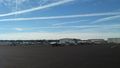
Georgeous day for flying!
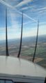
Note the contrail going from upper left of picture. You can see its shadow on the ground. I love flying.
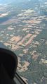
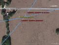
Approximate location of hash point
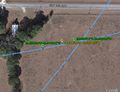
First pass at about 1300'. Yellow is the hash point. Measuring from Google Earth I came within 7' of the point. I amazed myself.
Second pass...about 5400' for the Mile High. Came within 70' this time. Still respectable considering I'm a mile high.
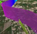
Oblique view of my two passes showing the relative elevation. Hashpoint labeled GNV.
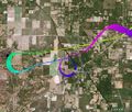
Overhead view of the two passes. The whole bit out to the west, changing colors, is me climbing from 1300' to 5400'. The 360 over Archer was because I realized I wouldn't have the altitude for the Mile High.


Achievements
Grumpa earned the Air geohash achievement
|
Mile High Award