Difference between revisions of "2012-12-26 48 8"
imported>RecentlyChanged (→Plans) |
imported>FippeBot m (Location) |
||
| (7 intermediate revisions by 2 users not shown) | |||
| Line 1: | Line 1: | ||
| − | |||
| − | |||
| − | |||
| − | |||
| − | |||
| − | |||
| − | |||
| − | |||
| − | |||
| − | |||
{{meetup graticule | {{meetup graticule | ||
| lat=48 | | lat=48 | ||
| Line 14: | Line 4: | ||
| date=2012-12-26 | | date=2012-12-26 | ||
}} | }} | ||
| − | |||
| − | |||
__NOTOC__ | __NOTOC__ | ||
== Location == | == Location == | ||
| Line 27: | Line 15: | ||
== Expedition == | == Expedition == | ||
| − | + | It became late this afternoon, because I slept over the day. Then we celebrated Christmas with a lot of visitors from my family. We had really a lot of fun and I drunk a glass of wine or four. It became later and later and it became more boring and boring after my younger cousin left. So I told my mother that I will go walking a little bit, just 3 or 4 hours. | |
| + | But she had the idea to ask the boyfriend of my little sister to go with me, he has drunken nothing and was bored like me. | ||
| + | So we went to go Geohashing. | ||
| + | |||
| + | We both were happy to get fresh air and we enjoyed the silence (no awkward silence). He needed a little bit to understand what Geohashing is, but in the end I think I've made it (Until we were there he thought we will find a cache). I don't know if he will ever do it again, but it was nice. | ||
| + | |||
| + | The Expedition itself worked well, first we came into a dead end, but for Hashing relations it was nothing really to talk much about, after this we found it easily. It was a beautiful spot, like a really old ruin out of old stones from a different time. Not that we could have catched this in the dark of the night in the forest. | ||
| + | Luckily we've had tolerance of 5 meters , less and we had had to climb the wall, which would have been not really funny because it was really wet, everything. | ||
| − | + | After this I offered him to show him a Geocache near our location, but he wanted to go back home so we went back home. | |
| − | |||
== Photos == | == Photos == | ||
| − | |||
| − | |||
| − | |||
<gallery perrow="5"> | <gallery perrow="5"> | ||
| + | Image:2012-12-26_48_8_Dragalong.JPG | What is he doing?? | ||
| + | Image:2012-12-26_48_8_smiling.JPG | ...going deep into the forest without any reason and smiling stupidly | ||
</gallery> | </gallery> | ||
== Achievements == | == Achievements == | ||
{{#vardefine:ribbonwidth|800px}} | {{#vardefine:ribbonwidth|800px}} | ||
| − | + | {{land geohash | latitude = 48 | longitude = 8 | date = 2012-12-26 | name = RecentlyChanged and maddas }} | |
| − | + | {{drag-along | latitude = 48 | longitude = 8 | date = 2012-12-26 | name = RecentlyChanged | partner = maddas }} | |
| − | + | {{Two to the N achievement | |
| − | + | | count = 0 | |
| − | + | | date = 2012-12-26 | |
| − | + | | latitude = 48 | |
| − | + | | longitude = 8 | |
| − | + | | name = maddas | |
| − | + | | reached = true | |
| − | + | }} | |
| − | |||
| − | |||
| − | |||
[[Category:Expeditions]] | [[Category:Expeditions]] | ||
| − | |||
[[Category:Expeditions with photos]] | [[Category:Expeditions with photos]] | ||
| − | |||
| − | |||
| − | |||
| − | |||
| − | |||
[[Category:Coordinates reached]] | [[Category:Coordinates reached]] | ||
| − | + | {{location|DE|BW|VS}} | |
| − | |||
| − | |||
| − | |||
| − | |||
| − | |||
| − | |||
| − | |||
| − | |||
| − | |||
| − | |||
| − | |||
| − | |||
| − | |||
| − | |||
| − | |||
| − | |||
| − | |||
Latest revision as of 00:25, 14 August 2019
| Wed 26 Dec 2012 in 48,8: 48.1741274, 8.1664288 geohashing.info google osm bing/os kml crox |
Location
Somewhere in the Forest, near my familiy home, probably I will try it, its so near!
Participants
Plans
It's easy for me to reach but I have to work the night before until 8 am and in the afternoon my family visits us because of Christmas. I hope I could take my bike or walk, but because I don't have much time I probably take my car.
Expedition
It became late this afternoon, because I slept over the day. Then we celebrated Christmas with a lot of visitors from my family. We had really a lot of fun and I drunk a glass of wine or four. It became later and later and it became more boring and boring after my younger cousin left. So I told my mother that I will go walking a little bit, just 3 or 4 hours. But she had the idea to ask the boyfriend of my little sister to go with me, he has drunken nothing and was bored like me. So we went to go Geohashing.
We both were happy to get fresh air and we enjoyed the silence (no awkward silence). He needed a little bit to understand what Geohashing is, but in the end I think I've made it (Until we were there he thought we will find a cache). I don't know if he will ever do it again, but it was nice.
The Expedition itself worked well, first we came into a dead end, but for Hashing relations it was nothing really to talk much about, after this we found it easily. It was a beautiful spot, like a really old ruin out of old stones from a different time. Not that we could have catched this in the dark of the night in the forest. Luckily we've had tolerance of 5 meters , less and we had had to climb the wall, which would have been not really funny because it was really wet, everything.
After this I offered him to show him a Geocache near our location, but he wanted to go back home so we went back home.
Photos
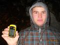
What is he doing??
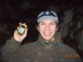
...going deep into the forest without any reason and smiling stupidly


Achievements
RecentlyChanged and maddas earned the Land geohash achievement
|
RecentlyChanged earned the Drag-along achievement
|
