Difference between revisions of "2012-12-26 54 -3"
imported>Alexandersmith (→Photos) |
m (Replacing http://wiki.xkcd.com/geohashing/MNB_Geohash with MNB Geohash) |
||
| (6 intermediate revisions by 2 users not shown) | |||
| Line 38: | Line 38: | ||
--> | --> | ||
<gallery perrow="2"> | <gallery perrow="2"> | ||
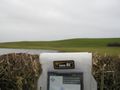
| − | Image:20121226_GeohashAchieved.jpg | + | Image:20121226_GeohashAutoPhoto.jpg | Auto-photo at the geo-hash. |
| + | Image:20121226_GeohashAchieved.jpg | Droid Geohash app showing my proximity to the geohash point. The location is visible in the background. | ||
</gallery> | </gallery> | ||
== Achievements == | == Achievements == | ||
| − | |||
| − | |||
| − | |||
| − | |||
| − | |||
| − | |||
| − | |||
| − | |||
| − | |||
| − | |||
| − | |||
| − | |||
| − | |||
| − | |||
[[Category:Expeditions]] | [[Category:Expeditions]] | ||
| − | |||
[[Category:Expeditions with photos]] | [[Category:Expeditions with photos]] | ||
| − | |||
| − | |||
| − | |||
| − | |||
| − | |||
| − | |||
| − | |||
| − | |||
| − | |||
[[Category:Coordinates not reached]] | [[Category:Coordinates not reached]] | ||
| − | |||
| − | |||
[[Category:Not reached - Mother Nature]] | [[Category:Not reached - Mother Nature]] | ||
| − | + | None, even the [[MNB Geohash|"Mother Nature's Bitch" Consolation Prize]] doesn't count because I could have chosen to wade out up to my knees in muddy and cold water. | |
| − | + | {{location|GB|ENG|CMA}} | |
| − | |||
| − | |||
| − | |||
| − | |||
| − | |||
| − | |||
| − | [[ | ||
| − | |||
| − | |||
Latest revision as of 11:14, 19 February 2020
| Wed 26 Dec 2012 in 54,-3: 54.1741274, -3.1664288 geohashing.info google osm bing/os kml crox |
Location
In a field, near Tytup Hall, North of Dalton-in-Furness.
Participants
Plans
Bag a mountain bike ride in the early part of the day, visit the meet-up point on the way back home to Barrow-in-Furness.
Expedition
The location was near a local minor road, and did not need any formal planning to reach. I had already planned to visit Dalton on my way back to Barrow, so it proved to be a very minor diversion for me.
I was able to park within 60 metres of the geohash. In had considered both the satellite images from google, and the recent rain-fall. Both suggested that if I wanted to stand on the actual point, then I may need rubber boots. Or a small boat. I made a tactical decision to accept a 'near-miss', and the result was that I was only within 23 metres of the hash point.
The Android application did try and tell me that I had made the geohash. I prefer to get within less than 5 metres of the geohash before I will consider it a success. In saying that I do acknowledge that consumer GPS receivers are usually accurate to about 10 metres, depending on the local conditions.
Photos

Auto-photo at the geo-hash.
Droid Geohash app showing my proximity to the geohash point. The location is visible in the background.


Achievements
None, even the "Mother Nature's Bitch" Consolation Prize doesn't count because I could have chosen to wade out up to my knees in muddy and cold water.