Difference between revisions of "2013-01-13 -27 153"
imported>Ged3000 (Created page with "{{meetup graticule | lat=-27 | lon=153 | date=2013-01-13 }} == Location == The geohash is someone's drive, in Chermside. == Who went == Ged3000 - by car. == T...") |
m (More specific location) |
||
| (2 intermediate revisions by 2 users not shown) | |||
| Line 18: | Line 18: | ||
== Photos == | == Photos == | ||
=== Ged3000 === | === Ged3000 === | ||
| − | + | <gallery perrow="4"> | |
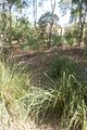
| + | Image:2013-01-13 -27 153 1.jpg | The nearby stream | ||
| + | Image:2013-01-13 -27 153 2.jpg | The path, marked by a chilli bush | ||
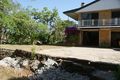
| + | Image:2013-01-13 -27 153 3.jpg | The refreshments | ||
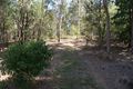
| + | Image:2013-01-13 -27 153 4.jpg | A well marked path | ||
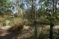
| + | Image:2013-01-13 -27 153 5.jpg | Going off-track | ||
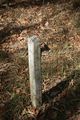
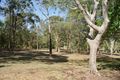
| + | Image:2013-01-13 -27 153 6.jpg | The geohash | ||
| + | Image:2013-01-13 -27 153 7.jpg | The view from the geohash | ||
| + | Image:2013-01-13 -27 153 8.jpg | Proof | ||
| + | </gallery> | ||
== Achievements == | == Achievements == | ||
| Line 24: | Line 33: | ||
[[Category:Expeditions]] | [[Category:Expeditions]] | ||
[[Category:Coordinates reached]] | [[Category:Coordinates reached]] | ||
| + | {{location|AU|QLD|BR}} | ||
Latest revision as of 19:07, 28 September 2020
| Sun 13 Jan 2013 in -27,153: -27.3885845, 153.0125804 geohashing.info google osm bing/os kml crox |
Location
The geohash is someone's drive, in Chermside.
Who went
Ged3000 - by car.
The Expedition
Ged3000
I'd carefully planned to visit this gehoash - after getting the notification, and finding out it was down the road. I promptly forgot all about it - remembering as I'd just driven past it! (Perfect timing, eh!?) Fortunately, it turned out I did have a GPS thingymabob, and so I could go track the place down!
The route was marked by a rather large chilli bush, and was formed by a rather well-formed trail for a good part of the journey. After a brief bit of off-roading, there was a lovely bit of wall to sit on, to enjoy the view of the forest.
Photos
Ged3000
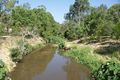
The nearby stream
The path, marked by a chilli bush
The refreshments
A well marked path
Going off-track
The geohash
The view from the geohash
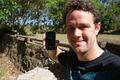
Proof


