Difference between revisions of "2013-01-22 41 -71"
imported>Vbob (→Plans) |
m (Location correction) |
||
| (14 intermediate revisions by 4 users not shown) | |||
| Line 47: | Line 47: | ||
Counted paces from the street sign to the river's edge, triangulated back and paced south to the hash point - but I can't prove that. | Counted paces from the street sign to the river's edge, triangulated back and paced south to the hash point - but I can't prove that. | ||
| − | I got there by walking out the right hand hinge side of my office door, down the hall and out the back door of the building, across the river (twice), down | + | I got there by walking out the right hand hinge side of my office door, down the hall and out the back door of the building, across the river (twice)(on different bridges), southwest down the riverbank, marked the hash, then walked southeast up the riverbank, up another street, in the front door of my office on the latch side - a full walking Tron - but I can't prove that. |
| − | It likely wasn't a helicopter in the older Googlemap photo - but probably a mobile boom worklift - when at the site I recognized the area as being the location of a highway overpass that was demolished a year or two ago - so I would have passed directly over the hashpoint about | + | [and I've decided that using footprints to mark out XKCD counts as a local timeout from the strict TRON guidelines....] |
| + | |||
| + | It likely wasn't a helicopter in the older Googlemap photo - but probably a mobile boom worklift - when at the site I recognized the area as being the location of a highway overpass that was demolished a year or two ago - so I would have passed directly over the hashpoint about 20 feet higher on the old onramp at least once a month - but I can't prove that. | ||
I was grinning foolishly - I can prove that. | I was grinning foolishly - I can prove that. | ||
| Line 58: | Line 60: | ||
== Photos == | == Photos == | ||
<!-- Insert pictures between the gallery tags using the following format: | <!-- Insert pictures between the gallery tags using the following format: | ||
| − | |||
--> | --> | ||
<gallery perrow="5"> | <gallery perrow="5"> | ||
| + | Image:41-71_2013.01.22a - hash in distance.jpg | hashpoint about half-mile south on other side of the river | ||
| + | Image:41-71_2013.01.22b - past where the sidewalk ends.jpg | just about a hundred feet past the end of the old sidewalk | ||
| + | Image:41-71_2013.01.22c - there used to be a bridge.jpg | where there used to be a 6-lane interstate highway overpass | ||
| + | Image:41-71_2013.01.22d - and an onramp.jpg | and an onramp up to the bridge | ||
| + | Image:41-71_2013.01.22e - now the internet is here.jpg | but now just grassy riverbank with internet footprints | ||
| + | Image:41-71_2013.01.22f - right here in the middle.jpg | to the hashpoint center of photo | ||
| + | Image:41-71_2013.01.22x - Vbob grin.jpg | Foolish Grin™ -4°F windchill version | ||
| + | Image:41-71_2013.01.22z - walk back the other side.jpg | then walk back to work carefully not crossing own path or retracing steps. | ||
</gallery> | </gallery> | ||
| Line 67: | Line 76: | ||
<!-- Add any achievement ribbons you earned below, or remove this section --> | <!-- Add any achievement ribbons you earned below, or remove this section --> | ||
| − | {{ | + | |
| + | {{Walk geohash | ||
| + | | latitude = 41 | ||
| + | | longitude = -71 | ||
| + | | date = 2013-01-22 | ||
| + | | name = [[User:Vbob|Vbob]] | ||
| + | | distance = 1760 paces from office to hash and back | ||
| + | }} | ||
| + | {{No_batteries_geohash | ||
| + | | latitude = 41 | ||
| + | | longitude = -71 | ||
| + | | date = 2013-01-22 | ||
| + | | name = [[User:Vbob|Vbob]] | ||
| + | }} | ||
| + | {{Frozen Geohash | ||
| + | | latitude = 41 | ||
| + | | longitude = -71 | ||
| + | | date = 2013-01-22 | ||
| + | | temperature = 21°F | ||
| + | | name = [[User:Vbob|Vbob]] | ||
| + | }} | ||
| + | {{Déjà vu geohash | ||
| latitude = 41 | | latitude = 41 | ||
| longitude = -71 | | longitude = -71 | ||
| date = 2013-01-22 | | date = 2013-01-22 | ||
| + | | olddate = 2010-12-17 and numerous earlier dates on a now demolished highway overpass probably 20' up, while on 2013-01-22 it was reached at ground level | ||
| name = [[User:Vbob|Vbob]] | | name = [[User:Vbob|Vbob]] | ||
}} | }} | ||
| − | |||
<!-- =============== USEFUL CATEGORIES FOLLOW ================ | <!-- =============== USEFUL CATEGORIES FOLLOW ================ | ||
Delete the next line ONLY if you have chosen the appropriate categories below. If you are unsure, don't worry. People will read your report and help you with the classification. --> | Delete the next line ONLY if you have chosen the appropriate categories below. If you are unsure, don't worry. People will read your report and help you with the classification. --> | ||
| − | |||
<!-- Potential categories. Please include all the ones appropriate to your expedition --> | <!-- Potential categories. Please include all the ones appropriate to your expedition --> | ||
| Line 83: | Line 112: | ||
--> | --> | ||
| − | + | ||
[[Category:Expeditions]] | [[Category:Expeditions]] | ||
| − | + | [[Category:Expedition without GPS]] | |
[[Category:Expeditions with photos]] | [[Category:Expeditions with photos]] | ||
| − | |||
| − | |||
| − | |||
| − | |||
| − | |||
[[Category:Coordinates reached]] | [[Category:Coordinates reached]] | ||
| − | + | <!-- or if you failed :( | |
| − | |||
| − | |||
[[Category:Coordinates not reached]] | [[Category:Coordinates not reached]] | ||
-- and a reason -- | -- and a reason -- | ||
| Line 111: | Line 133: | ||
(Don't forget to delete this final close comment marker) --> | (Don't forget to delete this final close comment marker) --> | ||
| + | {{location|US|RI|PR}} | ||
Latest revision as of 20:18, 16 May 2020
| Tue 22 Jan 2013 in 41,-71: 41.8193547, -71.4033966 geohashing.info google osm bing/os kml crox |
Location
Grassy (well, snowy) east bank of the Providence River
Participants
Plans
not quite half-mile south of where I work - good lunchtime stroll down the brick river walk
No GPS with me today, but all kinds of manmade reference points along the riverbank and adjacent street, so I should be able to pace myself to a good approximation of the hash point.
Wish the Peeron map had a distance scale - so shift over to Google-map to use theirs.
Hmmm - the Peeron satellite view shows grassy park, but Google-maps shows gravel with a helicopter parked!
Wish the Google-map satellite imagery had date stamps....
If I had a GPS with me, and trusted it to do a good track log, I could have tried a juggernaut-tron doing a beeline down one side of the riverwalk and coming back along the other side off the path...
Expedition
Sunny, bittery cold and windy - but I can't prove that.
Snow on the ground, probably too cold & dry to make a snowperson - but I forgot to even try, so I can't prove that.
Counted paces from the street sign to the river's edge, triangulated back and paced south to the hash point - but I can't prove that.
I got there by walking out the right hand hinge side of my office door, down the hall and out the back door of the building, across the river (twice)(on different bridges), southwest down the riverbank, marked the hash, then walked southeast up the riverbank, up another street, in the front door of my office on the latch side - a full walking Tron - but I can't prove that.
[and I've decided that using footprints to mark out XKCD counts as a local timeout from the strict TRON guidelines....]
It likely wasn't a helicopter in the older Googlemap photo - but probably a mobile boom worklift - when at the site I recognized the area as being the location of a highway overpass that was demolished a year or two ago - so I would have passed directly over the hashpoint about 20 feet higher on the old onramp at least once a month - but I can't prove that.
I was grinning foolishly - I can prove that.
Tracklog
Photos
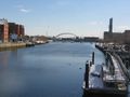
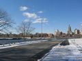
hashpoint about half-mile south on other side of the river
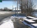
just about a hundred feet past the end of the old sidewalk
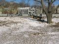
where there used to be a 6-lane interstate highway overpass
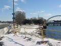
and an onramp up to the bridge
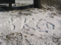
but now just grassy riverbank with internet footprints
to the hashpoint center of photo

Foolish Grin™ -4°F windchill version
then walk back to work carefully not crossing own path or retracing steps.


Achievements
Vbob earned the Walk geohash Achievement
|
Vbob earned the No Batteries Geohash Achievement
|

Vbob earned the Déjà Vu Geohash Achievement
|