Difference between revisions of "2013-01-27 48 11"
imported>Zertrin (Another success!) |
imported>Zertrin (report) |
||
| Line 1: | Line 1: | ||
| − | |||
| − | |||
| − | |||
| − | |||
| − | |||
| − | |||
| − | |||
| − | |||
| − | |||
| − | |||
{{meetup graticule | {{meetup graticule | ||
| lat=48 | | lat=48 | ||
| Line 18: | Line 8: | ||
__NOTOC__ | __NOTOC__ | ||
== Location == | == Location == | ||
| − | + | In the forest, between Dürrnhaar and Egmating, 20 km south-east of Munich. The hashpoint is located about 20 meters from a forest path. | |
== Participants == | == Participants == | ||
| − | + | * [[User:Zertrin|Zertrin]] | |
| − | + | * [[User:vermouthandgin|vermouthandgin]] | |
== Plans == | == Plans == | ||
| − | + | Not letting Zurich's graticule win the most active geohash achievement too easily! See the following: | |
| + | |||
| + | * Hey fellow geohashers! Have you read that : [[2013-01-26 47 8]] and the [[Talk:2013-01-26 47 8|talkpage]]. I don't feel like letting them win the "Most active graticule for January 2013" that easily. That's why I'm considering attempting both of the next hashes (tomorrow Sunday and Monday). With lot of luck it could even be possible to finish on a par if the hashes until the end of the month are favorable. For tomorrow, we'll maybe try a Sunrise Geohash achievement. For Monday, I may try it on morning before going to work. — [[User:Zertrin|Zertrin]] 15:19, 26 January 2013 (EST) | ||
| + | ** Challenge accepted. I don't actually have a lot of opportunities to hash in my beloved home graticule right now, but I think we'll manage to keep up and get another one of those shiny ribbons. Thanks for the motivation. --[[User:Calamus|Calamus]] 15:35, 26 January 2013 (EST) | ||
| + | *** Ha, I also had this sort of itching about challenging Zürich! However, there's a lot of stuff to do until Feb 4th for me. After that, - Bring. It. On. -[[User:The T-Man|The T-Man]] 17:26, 26 January 2013 (EST) | ||
| + | **** Oh, and yes: Making plans. Sunday's spot theoretically is in my corner of the town, but there's a family meeting coming up. Don't know how long that lasts. Monday, in return, looks nice. I'd start at about 14:40 at Central Station. -[[User:The T-Man|The T-Man]] 17:30, 26 January 2013 (EST) | ||
| + | |||
== Expedition == | == Expedition == | ||
| − | + | Quite easy hash, though not really near. We went by car (30 minutes trip, uneventful), parked not far away from the beginning of the path leading to the hash, walked towards it. | |
| + | |||
| + | This time, what Google was indicating as a path was really one, that could even be driven by car, hence the easy progression towards the hash. | ||
| + | |||
| + | Finding the exact spot didn't take much time. We built an XKCD marker made of woodsticks, took some pictures, did some engineering to take the pictures of both of us with the xkcd marker from above and then went back the same way we came. | ||
== Tracklog == | == Tracklog == | ||
| − | + | http://www.everytrail.com/view_trip.php?trip_id=1995692 | |
== Photos == | == Photos == | ||
| − | |||
| − | |||
| − | |||
<gallery perrow="5"> | <gallery perrow="5"> | ||
| + | Image:Zertrin 2013-01-27 48 11 - road through the forest 1.JPG | Next left: beginning of the forest path | ||
| + | Image:Zertrin 2013-01-27 48 11 - Beginning of the forest path.JPG | Beginning of the forest path, wide and practicable for once :) | ||
| + | Image:Zertrin 2013-01-27 48 11 - Path forest 1.JPG | The path through the forest. | ||
| + | Image:Zertrin 2013-01-27 48 11 - hash somewhere inside.JPG | The hash hides somewhere the forest in this direction | ||
| + | Image:Zertrin 2013-01-27 48 11 - Coordinates reached.png | Coordinates reached! | ||
| + | Image:Zertrin 2013-01-27 48 11 - Making of XKCD.JPG | Making of XKCD | ||
| + | Image:Zertrin 2013-01-27 48 11 - XKCD.JPG | XKCD | ||
| + | Image:Zertrin 2013-01-27 48 11 - Zertrin and vermouthandgin at hashpoint 1.JPG | [[User:Zertrin|Zertrin]] and [[User:vermouthandgin|vermouthandgin]] at hashpoint | ||
| + | Image:Zertrin 2013-01-27 48 11 - Zertrin and vermouthandgin at hashpoint 2.JPG | ... with better view of the XKCD | ||
| + | Image:Zertrin 2013-01-27 48 11 - Camera system 1.JPG | How to take a picture from above without hands? | ||
| + | Image:Zertrin 2013-01-27 48 11 - Camera system 2.JPG | Answer: just add some engineering to the forest :) | ||
| + | Image:Zertrin 2013-01-27 48 11 - vermouthandgin's iced cream.JPG | vermouthandgin's home made iced cream | ||
| + | Image:Zertrin 2013-01-27 48 11 - can you spot the XKCD.JPG | can you spot the XKCD? | ||
| + | Image:Zertrin 2013-01-27 48 11 - Forest path 2.JPG | The path, on the way back. | ||
| + | Image:Zertrin 2013-01-27 48 11 - road through the forest 2.JPG | [[User:vermouthandgin|vermouthandgin]] in happy mood :) | ||
| + | Image:Zertrin 2013-01-27 48 11 - Parking place.JPG | A parking near the hash, covered with many cm of snow. | ||
| + | Image:Zertrin 2013-01-27 48 11 - Landscape out of the forest.JPG | Landscape out of the forest | ||
| + | Image:Zertrin 2013-01-27 48 11 - Dürrnhaar.JPG | Dürrnhaar | ||
</gallery> | </gallery> | ||
| Line 44: | Line 59: | ||
<!-- Add any achievement ribbons you earned below, or remove this section --> | <!-- Add any achievement ribbons you earned below, or remove this section --> | ||
| − | |||
| − | |||
| − | |||
| − | |||
| − | |||
| − | |||
| − | |||
| − | |||
| − | |||
| − | |||
| − | |||
[[Category:Expeditions]] | [[Category:Expeditions]] | ||
| − | |||
[[Category:Expeditions with photos]] | [[Category:Expeditions with photos]] | ||
| − | + | ||
| − | |||
| − | |||
| − | |||
| − | |||
[[Category:Coordinates reached]] | [[Category:Coordinates reached]] | ||
| − | |||
| − | |||
| − | |||
| − | |||
| − | |||
| − | |||
| − | |||
| − | |||
| − | |||
| − | |||
| − | |||
| − | |||
| − | |||
| − | |||
| − | |||
| − | |||
| − | |||
| − | |||
Revision as of 16:43, 27 January 2013
| Sun 27 Jan 2013 in 48,11: 48.0019452, 11.7673281 geohashing.info google osm bing/os kml crox |
Location
In the forest, between Dürrnhaar and Egmating, 20 km south-east of Munich. The hashpoint is located about 20 meters from a forest path.
Participants
Plans
Not letting Zurich's graticule win the most active geohash achievement too easily! See the following:
- Hey fellow geohashers! Have you read that : 2013-01-26 47 8 and the talkpage. I don't feel like letting them win the "Most active graticule for January 2013" that easily. That's why I'm considering attempting both of the next hashes (tomorrow Sunday and Monday). With lot of luck it could even be possible to finish on a par if the hashes until the end of the month are favorable. For tomorrow, we'll maybe try a Sunrise Geohash achievement. For Monday, I may try it on morning before going to work. — Zertrin 15:19, 26 January 2013 (EST)
- Challenge accepted. I don't actually have a lot of opportunities to hash in my beloved home graticule right now, but I think we'll manage to keep up and get another one of those shiny ribbons. Thanks for the motivation. --Calamus 15:35, 26 January 2013 (EST)
- Ha, I also had this sort of itching about challenging Zürich! However, there's a lot of stuff to do until Feb 4th for me. After that, - Bring. It. On. -The T-Man 17:26, 26 January 2013 (EST)
- Oh, and yes: Making plans. Sunday's spot theoretically is in my corner of the town, but there's a family meeting coming up. Don't know how long that lasts. Monday, in return, looks nice. I'd start at about 14:40 at Central Station. -The T-Man 17:30, 26 January 2013 (EST)
- Ha, I also had this sort of itching about challenging Zürich! However, there's a lot of stuff to do until Feb 4th for me. After that, - Bring. It. On. -The T-Man 17:26, 26 January 2013 (EST)
- Challenge accepted. I don't actually have a lot of opportunities to hash in my beloved home graticule right now, but I think we'll manage to keep up and get another one of those shiny ribbons. Thanks for the motivation. --Calamus 15:35, 26 January 2013 (EST)
Expedition
Quite easy hash, though not really near. We went by car (30 minutes trip, uneventful), parked not far away from the beginning of the path leading to the hash, walked towards it.
This time, what Google was indicating as a path was really one, that could even be driven by car, hence the easy progression towards the hash.
Finding the exact spot didn't take much time. We built an XKCD marker made of woodsticks, took some pictures, did some engineering to take the pictures of both of us with the xkcd marker from above and then went back the same way we came.
Tracklog
http://www.everytrail.com/view_trip.php?trip_id=1995692
Photos
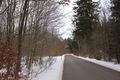
Next left: beginning of the forest path
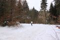
Beginning of the forest path, wide and practicable for once :)
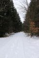
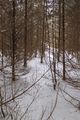
The path through the forest.
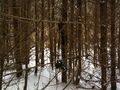
The hash hides somewhere the forest in this direction
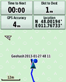
Coordinates reached!
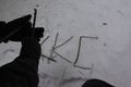
Making of XKCD

XKCD
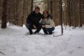
Zertrin and vermouthandgin at hashpoint

... with better view of the XKCD
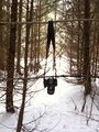
How to take a picture from above without hands?
Answer: just add some engineering to the forest :)

vermouthandgin's home made iced cream
can you spot the XKCD?
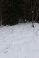
The path, on the way back.

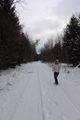
vermouthandgin in happy mood :)
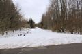
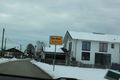
A parking near the hash, covered with many cm of snow.
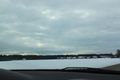
Landscape out of the forest
Dürrnhaar


