Difference between revisions of "2013-02-20 -37 144"
imported>Lachie (Created page with "{{meetup graticule | lat=-37 | lon=144 | date=2013-02-20 }} <!-- edit as necessary --> __NOTOC__ == Location == In a paddock near Ballan == Participants == * [[User:Lachie|Lac...") |
m (More specific location) |
||
| (19 intermediate revisions by 3 users not shown) | |||
| Line 5: | Line 5: | ||
}} | }} | ||
| − | + | ||
__NOTOC__ | __NOTOC__ | ||
== Location == | == Location == | ||
| Line 11: | Line 11: | ||
== Participants == | == Participants == | ||
| − | * [[User:Lachie| | + | * [[User:Lachie|Lachie]] |
== Planning== | == Planning== | ||
| − | + | My plan was to get two geohashes in one day, this being my second. See [[2013-02-20_-37_145]] for the first one. | |
| + | |||
== Expedition== | == Expedition== | ||
| + | I left my previous hash at 1:42pm on foot for the first bit then bike for the rest planning on | ||
| + | going to the Ballan hash via Yarra Glen- Kinglake - Whittlesea - Mount Macedon. | ||
| + | |||
| + | My first stop was to fill up | ||
| + | my water bottles at a petrol station in Yarry Glen. I've filled up my water bottle at the | ||
| + | outdoor tap at hundreds (or at least dozens) of petrol station all over Victoria and never | ||
| + | had a problem other than Beaufort where even at 3am the water is warm and tastes like dirt. | ||
| + | |||
| + | The water from the tap from the petrol station at Yarra Glen tasted a lot like petrol but | ||
| + | I didn't notice until I'd already had a few mouthfuls. I went to the tap in the bathroom | ||
| + | and rinsed out both my bottles several times but couldn't quite get rid of the taste. I informed the shopkeep that the water at the tap tasted like petrol but he didn't seem to care and told me it wasn't drinking water. | ||
| + | |||
| + | (Edit 24/02/13: When talking to Felix about this hash as soon as I mentioned the petrol staion in Yarra Glen he told me not to drink the water). | ||
| + | I continued my ride up to Kinglake and passed the bus shelter in Pheasant Creek where I | ||
| + | almost spent the night on a previous hash trip. The Kinglake to Kinglake west stretch of | ||
| + | the ride is a lot more pleasant than I remembered not having seen anything on my last | ||
| + | trip you are riding along a ridge for most of it with good views both ways with gentle | ||
| + | undulating hills. The last few km to Whittlesea is a relaxing moderately steep descent that you can roll down very fast without trying. At some point between Kinglake West and Whitlesea I started feeling | ||
| + | incredibly tired and slightly nauseous. In Whittlesea I decided i was not up for the original planned route of going over Mount Macedon and that I would take a short cut going through Mickleham knocking about 60km off the route. I continued on the shorter route and turned into Donnybrook road, about 1km down it (up it, it's quite steep) my vision was getting blurry and i could barely stay on my bike. I'm not sure if this was due to drinking too much petrol, being dehydrated(it was a hot day and I'd been hesitant to drink much water due to the petrol taste) or my just being a sookly lala. ~200k more riding was definitely not an option so i went home opting for the 8k ride to South Morang station rather than the 30km directly home. My only consolation being I'd never caught a train on the South Morang line before. | ||
| + | Within 10 minutes of getting on the train I felt perfectly fine and deeply regretted my decision. | ||
| + | ==Route== | ||
| + | route for this hash only http://goo.gl/maps/WyEJd | ||
== Photos == | == Photos == | ||
<!-- Insert pictures between the gallery tags using the following format: | <!-- Insert pictures between the gallery tags using the following format: | ||
| Line 27: | Line 50: | ||
<gallery perrow="5"> | <gallery perrow="5"> | ||
| − | + | image:2013-02-20 -37 144 shelter.jpg | The shelter I almost stayed the night in on my recent Kinglake geohash. | |
| − | + | Image:2013-02-20_-37_144_sad.JPG | Sad Lachlan arriving at home having only completed one hash today. | |
</gallery> | </gallery> | ||
== Achievements == | == Achievements == | ||
| + | {{Prize poultry | ||
| + | | latitude = -37 | ||
| + | | longitude = 144 | ||
| + | | date = 2013-02-20 | ||
| + | | name = Lachlan | ||
| + | | reason =of some combination of tiredness, dehydrations, poisoning and/or the reality of work the next day. | ||
| + | }} | ||
| + | |||
| Line 37: | Line 68: | ||
<!--[[Category:Expeditions with photos]]--> | <!--[[Category:Expeditions with photos]]--> | ||
[[Category:Coordinates reached]] | [[Category:Coordinates reached]] | ||
| + | {{location|AU|VIC|MO}} | ||
Latest revision as of 12:31, 1 August 2020
| Wed 20 Feb 2013 in -37,144: -37.6554927, 144.2887369 geohashing.info google osm bing/os kml crox |
Location
In a paddock near Ballan
Participants
Planning
My plan was to get two geohashes in one day, this being my second. See 2013-02-20_-37_145 for the first one.
Expedition
I left my previous hash at 1:42pm on foot for the first bit then bike for the rest planning on going to the Ballan hash via Yarra Glen- Kinglake - Whittlesea - Mount Macedon.
My first stop was to fill up my water bottles at a petrol station in Yarry Glen. I've filled up my water bottle at the outdoor tap at hundreds (or at least dozens) of petrol station all over Victoria and never had a problem other than Beaufort where even at 3am the water is warm and tastes like dirt.
The water from the tap from the petrol station at Yarra Glen tasted a lot like petrol but I didn't notice until I'd already had a few mouthfuls. I went to the tap in the bathroom and rinsed out both my bottles several times but couldn't quite get rid of the taste. I informed the shopkeep that the water at the tap tasted like petrol but he didn't seem to care and told me it wasn't drinking water.
(Edit 24/02/13: When talking to Felix about this hash as soon as I mentioned the petrol staion in Yarra Glen he told me not to drink the water).
I continued my ride up to Kinglake and passed the bus shelter in Pheasant Creek where I almost spent the night on a previous hash trip. The Kinglake to Kinglake west stretch of the ride is a lot more pleasant than I remembered not having seen anything on my last trip you are riding along a ridge for most of it with good views both ways with gentle undulating hills. The last few km to Whittlesea is a relaxing moderately steep descent that you can roll down very fast without trying. At some point between Kinglake West and Whitlesea I started feeling incredibly tired and slightly nauseous. In Whittlesea I decided i was not up for the original planned route of going over Mount Macedon and that I would take a short cut going through Mickleham knocking about 60km off the route. I continued on the shorter route and turned into Donnybrook road, about 1km down it (up it, it's quite steep) my vision was getting blurry and i could barely stay on my bike. I'm not sure if this was due to drinking too much petrol, being dehydrated(it was a hot day and I'd been hesitant to drink much water due to the petrol taste) or my just being a sookly lala. ~200k more riding was definitely not an option so i went home opting for the 8k ride to South Morang station rather than the 30km directly home. My only consolation being I'd never caught a train on the South Morang line before.
Within 10 minutes of getting on the train I felt perfectly fine and deeply regretted my decision.
Route
route for this hash only http://goo.gl/maps/WyEJd
Photos
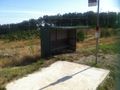
The shelter I almost stayed the night in on my recent Kinglake geohash.

Sad Lachlan arriving at home having only completed one hash today.


Achievements
Lachlan earned the Prize poultry Consolation Prize
|