Difference between revisions of "2013-02-25 -35 149"
imported>1PE (Created page with "{{subst:Expedition |lat = -35 |lon = 149 |date = 2013-02-25}}") |
m (More specific location) |
||
| (6 intermediate revisions by 4 users not shown) | |||
| Line 15: | Line 15: | ||
}} | }} | ||
| − | + | ||
__NOTOC__ | __NOTOC__ | ||
== Location == | == Location == | ||
| − | + | ||
| + | This was in open bush land on the south-eastern side of Jerrabomberra Mountain Reserve, in the midst of a new residential area named Jerrabomberra that has been established immediately south of Queanbeyan, New South Wales. | ||
== Participants == | == Participants == | ||
| − | + | ===[[User:1PE|1PE]]=== | |
| − | |||
== Plans == | == Plans == | ||
| − | + | ===[[User:1PE|1PE]]=== | |
| + | |||
| + | I planned to go during my lunch time. | ||
== Expedition == | == Expedition == | ||
| − | + | ===[[User:1PE|1PE]]=== | |
| + | My GPS navigator took me to the street immediately beside the hash position, where a locked boomgate gives vehicle access to the path around the margins of suburbia for emergency services in case of forest fire. | ||
| + | |||
| + | I needed to walk up about 100m into the bush; about as far as from my car to the top end of the house-block that neighbours the bushland. | ||
| + | |||
| + | I went to very nearly the correct longitude, estimated my angle of walk from the path, and headed into the scrubby woods using the longitude readings on the GPS for reference. | ||
| + | |||
| + | I suddenly heard an animal sound, and I was faced with a full-grown male kangaroo at about 5m distance. It had obviously been 'nesting' during the heat of the day, and had stood up when I stumbled into its vicinity. We looked at each other for a moment, and I took a picture of him. | ||
| + | |||
| + | I then circled around to better triangulate using the GPS car navigator; it does not readily 'settle'. I came back to the vicinity of the kangaroo from the other side, and he decided to bound away from his day-bed. | ||
| + | |||
| + | I found that I could 'settle' the position best when about 3m from his bed. Pictures followed, then I returned via the letterbox of the nearest house where I left some details so they can find this entry. | ||
| − | == | + | == Photos == |
| − | |||
| − | |||
| − | |||
| − | |||
| − | |||
<gallery perrow="5"> | <gallery perrow="5"> | ||
| + | file:2013-02-25_boomer_12.54.28.jpg|The 'boomer': the large male kangaroo | ||
| + | file:2013-02-25_-35_149_boomer_12.54b.JPG|Detail of the 'boomer' kangaroo | ||
| + | file:2013-02-25_hash-scene_13.08.32.jpg|The bush hash-scene. The boomer's nest is behind the low scrub behind. | ||
| + | file:2013-02-25_hash_13.08.01.jpg|hash | ||
</gallery> | </gallery> | ||
== Achievements == | == Achievements == | ||
{{#vardefine:ribbonwidth|800px}} | {{#vardefine:ribbonwidth|800px}} | ||
| − | |||
| − | |||
| − | + | * Land geohash | |
| − | + | * Couch potato for Boomer? | |
| − | |||
| − | |||
| − | |||
| − | |||
| − | |||
| − | |||
[[Category:Expeditions]] | [[Category:Expeditions]] | ||
| − | + | [[Category:Expeditions with photos]] | |
| − | [[Category:Expeditions with photos]] | ||
| − | |||
| − | |||
| − | |||
| − | |||
| − | |||
[[Category:Coordinates reached]] | [[Category:Coordinates reached]] | ||
| − | + | {{location|AU|NSW|QB}} | |
| − | |||
| − | |||
| − | |||
| − | |||
| − | |||
| − | |||
| − | |||
| − | |||
| − | |||
| − | |||
| − | |||
| − | |||
| − | |||
| − | |||
| − | |||
| − | |||
| − | |||
Latest revision as of 12:31, 1 August 2020
| Mon 25 Feb 2013 in -35,149: -35.3757303, 149.2176526 geohashing.info google osm bing/os kml crox |
Location
This was in open bush land on the south-eastern side of Jerrabomberra Mountain Reserve, in the midst of a new residential area named Jerrabomberra that has been established immediately south of Queanbeyan, New South Wales.
Participants
1PE
Plans
1PE
I planned to go during my lunch time.
Expedition
1PE
My GPS navigator took me to the street immediately beside the hash position, where a locked boomgate gives vehicle access to the path around the margins of suburbia for emergency services in case of forest fire.
I needed to walk up about 100m into the bush; about as far as from my car to the top end of the house-block that neighbours the bushland.
I went to very nearly the correct longitude, estimated my angle of walk from the path, and headed into the scrubby woods using the longitude readings on the GPS for reference.
I suddenly heard an animal sound, and I was faced with a full-grown male kangaroo at about 5m distance. It had obviously been 'nesting' during the heat of the day, and had stood up when I stumbled into its vicinity. We looked at each other for a moment, and I took a picture of him.
I then circled around to better triangulate using the GPS car navigator; it does not readily 'settle'. I came back to the vicinity of the kangaroo from the other side, and he decided to bound away from his day-bed.
I found that I could 'settle' the position best when about 3m from his bed. Pictures followed, then I returned via the letterbox of the nearest house where I left some details so they can find this entry.
Photos
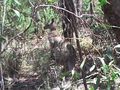
The 'boomer': the large male kangaroo
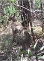
Detail of the 'boomer' kangaroo
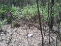
The bush hash-scene. The boomer's nest is behind the low scrub behind.
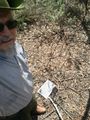
hash


Achievements
- Land geohash
- Couch potato for Boomer?