Difference between revisions of "2013-03-03 53 7"
imported>Elwingelfje (Created page with "{{subst:Expedition |lat = 53 |lon = 7 |date = 2013-03-03 }}") |
imported>FippeBot m (Location) |
||
| (7 intermediate revisions by one other user not shown) | |||
| Line 18: | Line 18: | ||
__NOTOC__ | __NOTOC__ | ||
== Location == | == Location == | ||
| − | + | Near the village of Vlagtwedde | |
== Participants == | == Participants == | ||
| − | + | [[User:Elwingelfje|Elwingelfje]] ([[User talk:Elwingelfje|talk]]) | |
| − | |||
== Plans == | == Plans == | ||
| − | + | Go there by car, walk a little bit, write some postcrossing cards, be back in time for dinner. | |
== Expedition == | == Expedition == | ||
| − | |||
| − | + | It was quite easy. For the first time in human history (ie in my somewhat skippy checking of Geohashing) the hash in the Emden graticule was actually in a spot feasible to get to without travelling at least 100 km. As I had to work at 15:30 PM this was quite convenient. So I decided to go for it! | |
| − | + | ||
| + | I drove the A7 until Winschoten, then turned right towards Vlagtwedde. Then I turned left towards Bourtange (wonderful old fortress town - but as I'd been there before I've not visited it now). Because the Dutch police frowns on taking pictures while driving (whyever would that be) I haven't got any of the journey there. To compensate I took pictures of a few things in my car (before setting off) and took some extra near the hashpoint. | ||
| + | |||
| + | Exactly as I surveyed, I first came across a small canal to the left and then to a lock in a bigger canal. Since the road from there looked earthy and muddy I decided to abandon car and continue on foot. I didn't fancy explaining geohasing to the local farmers while they pulled my car out of the muck. | ||
| + | |||
| + | It was exceptionally quiet and a bit bleak. The only people I met were a few cyclists. I also met three horses (behind a fences). I looked first for a bend in the canal and then for a kind of 'dip' in the opposite shore that was near the hashpoint. Lo and behold, there turned out to be no fence around the hashpoint! Apparently farmland near Vlagtwedde is so quiet that this is not necessary. Since the hashpoint was at the very edge of the field in the middle of some tractor tracks I figured it wouldn't hurt if I actually went there. (I wouldn't have done that if there had been a fence or plants that I could have trod on. The Dutch law concerning right of way says that you can't go somewhere if there's a fence or ditch obviously restricting access, or if you can damage the produce; I decided that none of these were applicable here.) | ||
| + | |||
| + | Yay, hashpoint reached! I wrote some postcrossing cards when I was back at the track and mailed them from a mailbox in Vlagtwedde. And that was that - a succesful hash. But none yet in my home graticule of Groningen unfortunately. Soon... | ||
== Photos == | == Photos == | ||
| − | + | ||
| − | |||
| − | |||
<gallery perrow="5"> | <gallery perrow="5"> | ||
| + | Image:2013_03_03_53_7_map.jpg | Preparations: my "map". (I didn't actually use it.) Points for anyone who understands even part of my scribbling... | ||
| + | Image:2013_03_03_53_7_cd_player.jpg.JPG | Odd title for a song... | ||
| + | Image:2013_03_03_53_7_cd_in_question.JPG | ... ah, it just means that my CD player hasn't come to terms with special characters yet. | ||
| + | Image:2013_03_03_53_7_lock.JPG | Said lock in the canal. This is also where I left my car. | ||
| + | Image:2013_03_03_53_7_artsy.JPG | Not sure if creative.. or just took a picture without meaning to. | ||
| + | Image:2013_03_03_53_7_cyclists.JPG | Retreating cyclists (you sure need courage to go cycling here on a cloudy Sunday afternoon in early March) | ||
| + | Image:2013_03_03_53_7_dip.JPG | The dip that indicates my hashpoint being near. | ||
| + | Image:2013_03_03_53_7_view.JPG | View from hashpoint | ||
| + | Image:2013_03_03_53_7_hashpoint.JPG | View of hashpoint after having reached it | ||
| + | Image:2013_03_03_53_7_me.JPG | Happy geohasher | ||
| + | Image:2013_03_03_53_7_sign_of_spring.JPG | What's that? Ooooh, I almost thought it was going to be springtime! Except that it was almost freezing. | ||
| + | Image:2013_03_03_53_7_postcards.JPG | My sent postcards - there should be a postcrossing geohashing achievement! | ||
</gallery> | </gallery> | ||
== Achievements == | == Achievements == | ||
{{#vardefine:ribbonwidth|800px}} | {{#vardefine:ribbonwidth|800px}} | ||
| − | |||
| + | {{land geohash | ||
| + | | latitude = 53 | ||
| + | | longitude = 7 | ||
| + | | date = 2013-03-03 | ||
| + | | name = elwingelfje | ||
| + | }} | ||
| − | + | {{No_batteries_geohash | |
| − | + | | latitude = 53 | |
| − | + | | longitude = 7 | |
| + | | date = 2013-03-03 | ||
| + | | name = elwingelfje | ||
| + | }} | ||
| − | + | {{Minesweeper geohash | |
| − | + | | graticule = Enschede, Netherlands | |
| − | + | | ranknumber = 2 | |
| − | + | | ne = true if graticule to the northeast has been hashed (optional) | |
| + | | w = true if graticule to the west has been hashed (optional) | ||
| + | | name = elwingelfje | ||
| + | }} | ||
| − | |||
[[Category:Expeditions]] | [[Category:Expeditions]] | ||
| − | |||
[[Category:Expeditions with photos]] | [[Category:Expeditions with photos]] | ||
| − | + | [[Category:Expedition without GPS]] | |
| − | [[Category:Expedition without GPS]] | ||
| − | |||
| − | |||
| − | |||
[[Category:Coordinates reached]] | [[Category:Coordinates reached]] | ||
| − | + | {{location|NL|GR}} | |
| − | |||
| − | |||
| − | |||
| − | |||
| − | |||
| − | |||
| − | |||
| − | |||
| − | |||
| − | |||
| − | |||
| − | |||
| − | |||
| − | |||
| − | |||
| − | |||
| − | |||
Latest revision as of 01:15, 14 August 2019
| Sun 3 Mar 2013 in 53,7: 53.0160004, 7.1443803 geohashing.info google osm bing/os kml crox |
Location
Near the village of Vlagtwedde
Participants
Plans
Go there by car, walk a little bit, write some postcrossing cards, be back in time for dinner.
Expedition
It was quite easy. For the first time in human history (ie in my somewhat skippy checking of Geohashing) the hash in the Emden graticule was actually in a spot feasible to get to without travelling at least 100 km. As I had to work at 15:30 PM this was quite convenient. So I decided to go for it!
I drove the A7 until Winschoten, then turned right towards Vlagtwedde. Then I turned left towards Bourtange (wonderful old fortress town - but as I'd been there before I've not visited it now). Because the Dutch police frowns on taking pictures while driving (whyever would that be) I haven't got any of the journey there. To compensate I took pictures of a few things in my car (before setting off) and took some extra near the hashpoint.
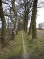
Exactly as I surveyed, I first came across a small canal to the left and then to a lock in a bigger canal. Since the road from there looked earthy and muddy I decided to abandon car and continue on foot. I didn't fancy explaining geohasing to the local farmers while they pulled my car out of the muck.
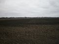
It was exceptionally quiet and a bit bleak. The only people I met were a few cyclists. I also met three horses (behind a fences). I looked first for a bend in the canal and then for a kind of 'dip' in the opposite shore that was near the hashpoint. Lo and behold, there turned out to be no fence around the hashpoint! Apparently farmland near Vlagtwedde is so quiet that this is not necessary. Since the hashpoint was at the very edge of the field in the middle of some tractor tracks I figured it wouldn't hurt if I actually went there. (I wouldn't have done that if there had been a fence or plants that I could have trod on. The Dutch law concerning right of way says that you can't go somewhere if there's a fence or ditch obviously restricting access, or if you can damage the produce; I decided that none of these were applicable here.)
Yay, hashpoint reached! I wrote some postcrossing cards when I was back at the track and mailed them from a mailbox in Vlagtwedde. And that was that - a succesful hash. But none yet in my home graticule of Groningen unfortunately. Soon...
Photos
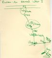
Preparations: my "map". (I didn't actually use it.) Points for anyone who understands even part of my scribbling...
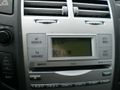
Odd title for a song...
... ah, it just means that my CD player hasn't come to terms with special characters yet.
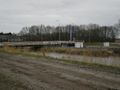
Said lock in the canal. This is also where I left my car.
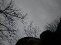
Not sure if creative.. or just took a picture without meaning to.
Retreating cyclists (you sure need courage to go cycling here on a cloudy Sunday afternoon in early March)
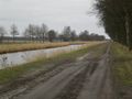
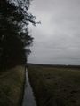
The dip that indicates my hashpoint being near.
View from hashpoint
View of hashpoint after having reached it
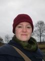
Happy geohasher
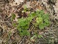
What's that? Ooooh, I almost thought it was going to be springtime! Except that it was almost freezing.
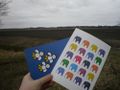
My sent postcards - there should be a postcrossing geohashing achievement!


Achievements
elwingelfje earned the Land geohash achievement
|
elwingelfje earned the No Batteries Geohash Achievement
|
elwingelfje achieved level 2 of the Minesweeper Geohash achievement
|