2013-03-16 32 35
| Sat 16 Mar 2013 in 32,35: 32.6734163, 35.4521782 geohashing.info google osm bing/os kml crox |
Location
A field at Kfar Kish, near mount Tavor.
Participants
Maoz, my dad.
Plans
Having a nice and free Saturday with only the two of us at home, we wanted to have a trip to somewhere nice, and luckily for us the hash fell in a beautiful area that could be combined with some nice hike around the Sea of Galilee/ Mount Tavor region.
Expedition
After making a map of Kfar Kish (that I forgot at home) and finding out our good camera was taken by mom (so this trip is a little lighter on the images than most of my reports), we got to the car and drove north all the way to the spot. Before entering the village we stopped near a wheat field, that turned out to be a nice little spot by a little stream and with view to the mountain, the lunch we bought in the way.
We than entered the village, found the road to the correct field and had about a kilometer to walk between the wheat fields and the olive plantations till finding the right spot, and then kept on walking and getting lost through the fields, along the way seeing the locust, that swarms of it crossed the border to Israel this month. After about an hour of that we moved on to two hikes in the area to the springs around Yavne'el and then to the Sea of Galilee, but that's a different story.
Photos
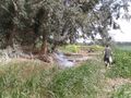
Stopping for lunch near a stream.
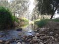
Hidden stream.
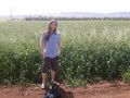
Omri at the coordinates.
The coordinates should be about a meter from us.
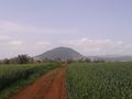
Mount Tavor.
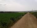
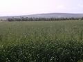
Walking between the fields.
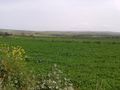
Enjoy it while it lasts, the green season is short around here.


