Difference between revisions of "2013-03-26 39 -77"
imported>OfficeLinebacker (→Photos) |
m (Location correction) |
||
| (6 intermediate revisions by 5 users not shown) | |||
| Line 1: | Line 1: | ||
| − | |||
| − | |||
| − | |||
| − | |||
| − | |||
| − | |||
| − | |||
| − | |||
| − | |||
| − | |||
{{meetup graticule | {{meetup graticule | ||
| lat=39 | | lat=39 | ||
| Line 58: | Line 48: | ||
{{#vardefine:ribbonwidth|800px}} | {{#vardefine:ribbonwidth|800px}} | ||
<!-- Add any achievement ribbons you earned below, or remove this section --> | <!-- Add any achievement ribbons you earned below, or remove this section --> | ||
| + | {{Tron | ||
| + | | latitude = 39 | ||
| + | | longitude = -77 | ||
| + | | date = 2013-03-26 | ||
| + | | name = OfficeLinebacker | ||
| + | | tracklog = http://goo.gl/maps/czbbO | ||
| + | | possessive = his | ||
| + | | | ||
| + | }} | ||
| + | {{consecutive geohash | ||
| + | | count = 4 | ||
| + | | latitude = 38 | ||
| + | | longitude = -76 | ||
| + | | date = 2013-03-23 | ||
| + | | name = OfficeLinebacker | ||
| + | }} | ||
| − | |||
| − | |||
| − | |||
| − | |||
| − | |||
| − | |||
| − | |||
| − | |||
| − | |||
| − | |||
[[Category:Expeditions]] | [[Category:Expeditions]] | ||
| − | |||
[[Category:Expeditions with photos]] | [[Category:Expeditions with photos]] | ||
| − | |||
| − | |||
| − | |||
| − | |||
| − | |||
[[Category:Coordinates reached]] | [[Category:Coordinates reached]] | ||
| − | + | {{location|US|MD|CR}} | |
| − | |||
| − | |||
| − | |||
| − | |||
| − | |||
| − | |||
| − | |||
| − | |||
| − | |||
| − | |||
| − | |||
| − | |||
| − | |||
| − | |||
| − | |||
| − | |||
| − | |||
Latest revision as of 20:19, 16 May 2020
| Tue 26 Mar 2013 in 39,-77: 39.3601815, -77.0628796 geohashing.info google osm bing/os kml crox |
Location
Right next to a bridge over a stream in Mt. Airy, MD/Lisbon, MD
Participants
OfficeLinebacker headed over after work
Plans
The plan was to leave from Bethesda at 3pm to try to beat traffic to get there by 4:30. This was a success even though I stopped for ME Swings coffee beans on the way.
Expedition
Well I got there and I didn't realize there was a stream there--the satellite photo looked like it was a small clearing behind a tree at an intersection. I was worried I wouldn't be able to get there but after I made a U-turn I pulled over onto the shoulder just before the bridge. I hopped the guardrail and was able to walk out into the stream bed.
Based on how soft and muddy the ground was, and how the grasses were swept down, there was at least two feet of water covering the exact spot within the past few days. Luckily today, the geohash spot was about two feet from the edge of the river. Had it been a few days earlier, I would have been MNB (Mother Nature's Bitch).
Pretty little spot.
Tracklog
Photos
Note: cell phone reception was very poor and picture uploading at the exact spot failed. Thus the distances--uploading was completed on the way home.
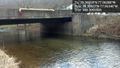
Literally three feet from the edge of the stream @39.3592,-77.0635

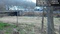
Silly vrin @39.3531,-77.0675
If it was last week I would have been Mother Nature's bitch @39.3489,-77.0692


Achievements
OfficeLinebacker earned the Tron achievement
|
OfficeLinebacker earned the Consecutive geohash achievement
|