Difference between revisions of "2013-03-28 38 -76"
imported>OfficeLinebacker (My boots [http://www.openstreetmap.org/?lat=38.67177080&lon=-76.17030402&zoom=16&layers=B000FTF @38.6718,-76.1703]) |
m (Replacing http://wiki.xkcd.com/geohashing/2013-03-28_38_-77 with 2013-03-28 38 -77) |
||
| (10 intermediate revisions by 4 users not shown) | |||
| Line 1: | Line 1: | ||
| − | |||
| − | |||
| − | |||
| − | |||
| − | |||
| − | |||
| − | |||
| − | |||
| − | |||
| − | |||
{{meetup graticule | {{meetup graticule | ||
| lat=38 | | lat=38 | ||
| Line 19: | Line 9: | ||
== Location == | == Location == | ||
<!-- where you've surveyed the hash to be --> | <!-- where you've surveyed the hash to be --> | ||
| + | In a swamp/marsh about 100 feet from a road in Oxford, MD | ||
== Participants == | == Participants == | ||
<!-- who attended: If you link to your wiki user name in this section, your expedition will be picked up by the various statistics generated for geohashing. You may use three tildes ~ as a shortcut to automatically insert the user signature of the account you are editing with. | <!-- who attended: If you link to your wiki user name in this section, your expedition will be picked up by the various statistics generated for geohashing. You may use three tildes ~ as a shortcut to automatically insert the user signature of the account you are editing with. | ||
--> | --> | ||
| + | [[User:OfficeLinebacker|OfficeLinebacker]] ([[User talk:OfficeLinebacker|talk]])OfficeLinebacker | ||
== Plans == | == Plans == | ||
| Line 30: | Line 22: | ||
<!-- how it all turned out. your narrative goes here. --> | <!-- how it all turned out. your narrative goes here. --> | ||
| + | After [[2013-03-28 38 -77|reaching the geohash for Washington DC West]], I decided to try for this one. I took the Beltway to 50 and crossed the Bay Bridge as well as the Kent Narrows Bridge, where the flatbed of a truck carrying a load of sod had collapsed under the weight and literally broken in half. I couldn't take a pic, unfortunately. | ||
| + | |||
| + | The area was in Oxford, MD, on the Eastern Shore. I had to push my way through some tall grass. The ground was a really muddy marsh near a river. Carnivores take pieces of deer and stuff and eat it out there, as witnessed by a deer bone found by itself on the grass. Going was very tough as I had to choose my steps carefully. I tried to stick to the open areas (not with the stiff grass) and aim for the clumps where the footing was solid. | ||
| + | |||
| + | The GPS dance took a while as accuracy was very low, but I finally zeroed in on the spot. Just as I started to head back, I picked the wrong foot spot and my leg sank into the mud up to my calf. The next step was quick and my other foot sank in, as well. I quickly went to my hands and barely was able to get my right foot out of the muck--it almost sucked my boot off. | ||
| + | |||
| + | After that I made it back to shore with only one more time my boot sinking into the mud but not even up to the ankle. | ||
| + | |||
| + | I got back to the car and took off my boots and put them in the passenger side footwell to try to dry them and dry my soaking wet left sock. | ||
| − | |||
== Tracklog == | == Tracklog == | ||
<!-- if your GPS device keeps a log, you may post a link here --> | <!-- if your GPS device keeps a log, you may post a link here --> | ||
| Line 43: | Line 43: | ||
Image:2013-03-28_38_-76_13-39-29-223.jpg | Silly grin [http://www.openstreetmap.org/?lat=38.67176767&lon=-76.17029893&zoom=16&layers=B000FTF @38.6718,-76.1703] | Image:2013-03-28_38_-76_13-39-29-223.jpg | Silly grin [http://www.openstreetmap.org/?lat=38.67176767&lon=-76.17029893&zoom=16&layers=B000FTF @38.6718,-76.1703] | ||
| − | Image:2013-03-28_38_-76_13-39-39-990.jpg | | + | Image:2013-03-28_38_-76_13-39-39-990.jpg | The view towards the water [http://www.openstreetmap.org/?lat=38.67176768&lon=-76.17029897&zoom=16&layers=B000FTF @38.6718,-76.1703] |
| − | Image:2013-03-28_38_-76_13-39-50-107.jpg | [http://www.openstreetmap.org/?lat=38.67176765&lon=-76.17029897&zoom=16&layers=B000FTF @38.6718,-76.1703] | + | Image:2013-03-28_38_-76_13-39-50-107.jpg | The view facing the shore. Don't be fooled, this is not solid ground. Watch your step! [http://www.openstreetmap.org/?lat=38.67176765&lon=-76.17029897&zoom=16&layers=B000FTF @38.6718,-76.1703] |
Image:2013-03-28_38_-76_13-40-36-814.jpg | My boots [http://www.openstreetmap.org/?lat=38.67177080&lon=-76.17030402&zoom=16&layers=B000FTF @38.6718,-76.1703] | Image:2013-03-28_38_-76_13-40-36-814.jpg | My boots [http://www.openstreetmap.org/?lat=38.67177080&lon=-76.17030402&zoom=16&layers=B000FTF @38.6718,-76.1703] | ||
| Line 53: | Line 53: | ||
{{#vardefine:ribbonwidth|800px}} | {{#vardefine:ribbonwidth|800px}} | ||
<!-- Add any achievement ribbons you earned below, or remove this section --> | <!-- Add any achievement ribbons you earned below, or remove this section --> | ||
| + | {{Multihash2 | count = 2 | date = 2013-03-28 | name = OfficeLinebacker | }} | ||
| − | |||
| − | |||
| − | |||
| − | |||
| − | |||
| − | |||
| − | |||
| − | |||
| − | |||
| − | |||
| − | |||
[[Category:Expeditions]] | [[Category:Expeditions]] | ||
| − | |||
[[Category:Expeditions with photos]] | [[Category:Expeditions with photos]] | ||
| − | |||
| − | |||
| − | |||
| − | |||
| − | |||
[[Category:Coordinates reached]] | [[Category:Coordinates reached]] | ||
| − | + | {{location|US|MD|TA}} | |
| − | |||
| − | |||
| − | |||
| − | |||
| − | |||
| − | |||
| − | |||
| − | |||
| − | |||
| − | |||
| − | |||
| − | |||
| − | |||
| − | |||
| − | |||
| − | |||
| − | |||
Latest revision as of 09:54, 19 February 2020
| Thu 28 Mar 2013 in 38,-76: 38.6717396, -76.1702692 geohashing.info google osm bing/os kml crox |
Location
In a swamp/marsh about 100 feet from a road in Oxford, MD
Participants
OfficeLinebacker (talk)OfficeLinebacker
Plans
Expedition
After reaching the geohash for Washington DC West, I decided to try for this one. I took the Beltway to 50 and crossed the Bay Bridge as well as the Kent Narrows Bridge, where the flatbed of a truck carrying a load of sod had collapsed under the weight and literally broken in half. I couldn't take a pic, unfortunately.
The area was in Oxford, MD, on the Eastern Shore. I had to push my way through some tall grass. The ground was a really muddy marsh near a river. Carnivores take pieces of deer and stuff and eat it out there, as witnessed by a deer bone found by itself on the grass. Going was very tough as I had to choose my steps carefully. I tried to stick to the open areas (not with the stiff grass) and aim for the clumps where the footing was solid.
The GPS dance took a while as accuracy was very low, but I finally zeroed in on the spot. Just as I started to head back, I picked the wrong foot spot and my leg sank into the mud up to my calf. The next step was quick and my other foot sank in, as well. I quickly went to my hands and barely was able to get my right foot out of the muck--it almost sucked my boot off.
After that I made it back to shore with only one more time my boot sinking into the mud but not even up to the ankle.
I got back to the car and took off my boots and put them in the passenger side footwell to try to dry them and dry my soaking wet left sock.
Tracklog
Photos
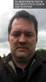
Silly grin @38.6718,-76.1703
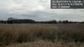
The view towards the water @38.6718,-76.1703
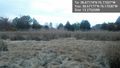
The view facing the shore. Don't be fooled, this is not solid ground. Watch your step! @38.6718,-76.1703
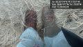
My boots @38.6718,-76.1703


Achievements
OfficeLinebacker earned the Multihash Achievement
|