Difference between revisions of "2013-03-28 38 -77"
imported>OfficeLinebacker ([live] In a forest near Pirate's Cove waterpark in Lorton, VA) |
m (Replacing http://wiki.xkcd.com/geohashing/2013-03-28_38_-76 with 2013-03-28 38 -76) |
||
| (12 intermediate revisions by 4 users not shown) | |||
| Line 1: | Line 1: | ||
| − | |||
| − | |||
| − | |||
| − | |||
| − | |||
| − | |||
| − | |||
| − | |||
| − | |||
| − | |||
{{meetup graticule | {{meetup graticule | ||
| lat=38 | | lat=38 | ||
| Line 19: | Line 9: | ||
== Location == | == Location == | ||
<!-- where you've surveyed the hash to be --> | <!-- where you've surveyed the hash to be --> | ||
| + | In some woods next to the parking lot for Pirates Cove waterpark in Lorton VA. Apparently they store RVs here in the offseason. | ||
== Participants == | == Participants == | ||
<!-- who attended: If you link to your wiki user name in this section, your expedition will be picked up by the various statistics generated for geohashing. You may use three tildes ~ as a shortcut to automatically insert the user signature of the account you are editing with. | <!-- who attended: If you link to your wiki user name in this section, your expedition will be picked up by the various statistics generated for geohashing. You may use three tildes ~ as a shortcut to automatically insert the user signature of the account you are editing with. | ||
--> | --> | ||
| + | [[User:OfficeLinebacker|OfficeLinebacker]] ([[User talk:OfficeLinebacker|talk]])OfficeLinebacker | ||
== Plans == | == Plans == | ||
| Line 30: | Line 22: | ||
<!-- how it all turned out. your narrative goes here. --> | <!-- how it all turned out. your narrative goes here. --> | ||
| + | Set out from Rockville at about 9:50. This was fairly straightforward as the GPS took me right to the driveway of the park. Once I got inside I detoured based on my own survey because the GPS would not have taken me to the closest parking lot. Once I arrived I realized that the vehicles I saw on the satellite pic are not buses of schoolchildren as I thought, but RVs. They rent out the lot to RV owners. It's a very desirable spot. I talked to a guy who said he was on a waiting list for three years. | ||
| + | |||
| + | There is also temporary (only during the offseason) storage right next to it. | ||
| + | |||
| + | I parked the car next to a pile of firewood and set off into the woods. There was a path which I should have used because even though it was windy, it would have taken me very close to the spot. Once I realized this I got on the path. A fallen tree which formed a bridge over a ravine showed the way to the exact location so I crossed it and took my pictures. Nice little location. | ||
| + | |||
| + | The GPS wasn't very exact and kept shifting accuracy but I am reasonably confident that at one point I was within a few feet of the exact spot. | ||
| + | |||
| + | Once I finished, I decided to head to [[2013-03-28 38 -76|the geohash for the next graticule over]]. | ||
| − | |||
== Tracklog == | == Tracklog == | ||
<!-- if your GPS device keeps a log, you may post a link here --> | <!-- if your GPS device keeps a log, you may post a link here --> | ||
| Line 40: | Line 40: | ||
--> | --> | ||
<gallery perrow="5"> | <gallery perrow="5"> | ||
| + | |||
| + | Image:2013-03-28_38_-77_10-56-57-600.jpg | Silly grin [http://www.openstreetmap.org/?lat=38.67174007&lon=-77.17028110&zoom=16&layers=B000FTF @38.6717,-77.1703] | ||
| + | |||
| + | Image:2013-03-28_38_-77_10-57-23-034.jpg | Crossing the bridge [http://www.openstreetmap.org/?lat=38.67174027&lon=-77.17028190&zoom=16&layers=B000FTF @38.6717,-77.1703] | ||
| + | |||
| + | Image:2013-03-28_38_-77_10-58-21-677.jpg | I got to cross this natural bridge to teach the location [http://www.openstreetmap.org/?lat=38.67174035&lon=-77.17028315&zoom=16&layers=B000FTF @38.6717,-77.1703] | ||
| + | |||
| + | Image:2013-03-28_38_-77_11-03-30-929.jpg | Trail in the woods [http://www.openstreetmap.org/?lat=38.67179937&lon=-77.17065448&zoom=16&layers=B000FTF @38.6718,-77.1707] | ||
</gallery> | </gallery> | ||
| Line 45: | Line 53: | ||
{{#vardefine:ribbonwidth|800px}} | {{#vardefine:ribbonwidth|800px}} | ||
<!-- Add any achievement ribbons you earned below, or remove this section --> | <!-- Add any achievement ribbons you earned below, or remove this section --> | ||
| + | {{consecutive geohash 2 | ||
| + | | count = 6 | ||
| + | | latitude = 38 | ||
| + | | longitude = -76 | ||
| + | | date = 2013-03-23 | ||
| + | | name = OfficeLinebacker | ||
| + | }} | ||
| − | |||
| − | |||
| − | |||
| − | |||
| − | |||
| − | |||
| − | |||
| − | |||
| − | |||
| − | |||
| − | |||
[[Category:Expeditions]] | [[Category:Expeditions]] | ||
| − | |||
[[Category:Expeditions with photos]] | [[Category:Expeditions with photos]] | ||
| − | |||
| − | |||
| − | |||
| − | |||
| − | |||
[[Category:Coordinates reached]] | [[Category:Coordinates reached]] | ||
| − | + | {{location|US|VA|FX}} | |
| − | |||
| − | |||
| − | |||
| − | |||
| − | |||
| − | |||
| − | |||
| − | |||
| − | |||
| − | |||
| − | |||
| − | |||
| − | |||
| − | |||
| − | |||
| − | |||
| − | |||
Latest revision as of 09:54, 19 February 2020
| Thu 28 Mar 2013 in 38,-77: 38.6717396, -77.1702692 geohashing.info google osm bing/os kml crox |
Location
In some woods next to the parking lot for Pirates Cove waterpark in Lorton VA. Apparently they store RVs here in the offseason.
Participants
OfficeLinebacker (talk)OfficeLinebacker
Plans
Expedition
Set out from Rockville at about 9:50. This was fairly straightforward as the GPS took me right to the driveway of the park. Once I got inside I detoured based on my own survey because the GPS would not have taken me to the closest parking lot. Once I arrived I realized that the vehicles I saw on the satellite pic are not buses of schoolchildren as I thought, but RVs. They rent out the lot to RV owners. It's a very desirable spot. I talked to a guy who said he was on a waiting list for three years.
There is also temporary (only during the offseason) storage right next to it.
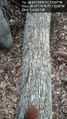
I parked the car next to a pile of firewood and set off into the woods. There was a path which I should have used because even though it was windy, it would have taken me very close to the spot. Once I realized this I got on the path. A fallen tree which formed a bridge over a ravine showed the way to the exact location so I crossed it and took my pictures. Nice little location.
The GPS wasn't very exact and kept shifting accuracy but I am reasonably confident that at one point I was within a few feet of the exact spot.
Once I finished, I decided to head to the geohash for the next graticule over.
Tracklog
Photos

Silly grin @38.6717,-77.1703
Crossing the bridge @38.6717,-77.1703
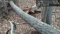
I got to cross this natural bridge to teach the location @38.6717,-77.1703
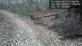
Trail in the woods @38.6718,-77.1707


Achievements
OfficeLinebacker earned the Consecutive geohash achievement
|