Difference between revisions of "2013-03-30 38 -77"
imported>OfficeLinebacker ([live picture] Silly grin [http://www.openstreetmap.org/?lat=38.31099593&lon=-77.07586847&zoom=16&layers=B000FTF @38.3110,-77.0759]) |
m (Replacing http://wiki.xkcd.com/geohashing/2013-03-30_39_-78 with 2013-03-30 39 -78) |
||
| (8 intermediate revisions by 3 users not shown) | |||
| Line 28: | Line 28: | ||
== Plans == | == Plans == | ||
<!-- what were the original plans --> | <!-- what were the original plans --> | ||
| − | I hope to leave Rockville around 12:30 pm and get there around 2. Then head up a different way to pick up Allison, and from there go to the [ | + | I hope to leave Rockville around 12:30 pm and get there around 2. Then head up a different way to pick up Allison, and from there go to the [[2013-03-30 39 -78|Cumberland MD geohash for today]]. |
I hope to earn the Tron achievement for today's expeditions. | I hope to earn the Tron achievement for today's expeditions. | ||
| Line 34: | Line 34: | ||
== Expedition == | == Expedition == | ||
<!-- how it all turned out. your narrative goes here. --> | <!-- how it all turned out. your narrative goes here. --> | ||
| + | So I set out from Rockville thinking it would be a 1h20m ride and it was not. There is terrible traffic in Waldorf. Someone at a gas station said it's like that every weekend since they installed a couple of traffic lights for a shopping center. Sure enough, once I passed those lights, traffic was fine. | ||
| + | |||
| + | Anyway I took Rt 301 and crossed the Potomac. Saw some huge chimneys, like a power plant or something but I also noticed some big pipes extending out to some docks, so maybe it's an oil depot or something. | ||
| + | |||
| + | Anyway getting to the spot was fairly straightforward, pulled off on the side of the road and went crashing into the underbrush. Got stuck with these thorny vines (they are everywhere in this area, have had to deal with them on every offroad expedition) and finally into the woods. I found a narrow track which led me part of the way there, then through the brush again. | ||
| + | |||
| + | I went back to my car and decided to drive on the narrow dirt track to see where it went. It ended near a swamp--I assume it's used infrequently by hunters. | ||
| + | |||
| + | Left and headed to pick up Allison for the [[2013-03-30 39 -78|Cumberland, MD hashpoint expedition]]. | ||
== Tracklog == | == Tracklog == | ||
| Line 55: | Line 64: | ||
Image:2013-03-30_38_-77_15-17-39-229.jpg | Silly grin [http://www.openstreetmap.org/?lat=38.31099593&lon=-77.07586847&zoom=16&layers=B000FTF @38.3110,-77.0759] | Image:2013-03-30_38_-77_15-17-39-229.jpg | Silly grin [http://www.openstreetmap.org/?lat=38.31099593&lon=-77.07586847&zoom=16&layers=B000FTF @38.3110,-77.0759] | ||
| + | |||
| + | Image:2013-03-30_38_-77_15-18-11-074.jpg | The view [http://www.openstreetmap.org/?lat=38.31102157&lon=-77.07586420&zoom=16&layers=B000FTF @38.3110,-77.0759] | ||
| + | |||
| + | Image:2013-03-30_38_-77_15-33-33-961.jpg | I decided to try to drive on that little car track in this is the end of the car track [http://www.openstreetmap.org/?lat=38.31164183&lon=-77.07268455&zoom=16&layers=B000FTF @38.3116,-77.0727] | ||
</gallery> | </gallery> | ||
| Line 61: | Line 74: | ||
<!-- Add any achievement ribbons you earned below, or remove this section --> | <!-- Add any achievement ribbons you earned below, or remove this section --> | ||
| + | {{Tron | ||
| + | | latitude = 38 | ||
| + | | longitude = -77 | ||
| + | | date = 2013-03-30 | ||
| + | | tracklog = https://maps.google.com/maps?saddr=Rockville,+MD&daddr=38.3109856,+-77.0758843+to:38.5871314,-77.3329612+to:3805+Whitman+Rd,+Annandale,+VA+to:39.3109856,+-78.0758843+to:Rockville,+MD&hl=en&sll=38.721948,-77.203674&sspn=1.165708,1.842957&geocode=Fd1fVAIdCr5m-ykVkeP-LCq2iTEk38nZEL6l7A%3BFUqUSAIdVOpn-w%3BFfvKTAIdH_5j-ymV4Dabqvm2iTE9a6KGikBJPA%3BFVivUAIdIYFl-ynltCbt80y2iTG7lfAjluxsWA%3BFYrWVwIdFKhY-w%3BFd1fVAIdCr5m-ykVkeP-LCq2iTEk38nZEL6l7A&t=h&mra=ls&via=2&z=8 | ||
| + | | possessive = his | ||
| + | | name = OfficeLinebacker | ||
| + | | | ||
| + | }} | ||
| − | |||
| − | |||
| − | |||
| − | + | {{consecutive geohash 2 | |
| − | + | | count = 8 | |
| − | + | | latitude = 38 | |
| − | + | | longitude = -76 | |
| + | | date = 2013-03-23 | ||
| + | | name = OfficeLinebacker | ||
| + | }} | ||
| − | |||
[[Category:Expeditions]] | [[Category:Expeditions]] | ||
| − | + | [[Category:Coordinates reached]] | |
[[Category:Expeditions with photos]] | [[Category:Expeditions with photos]] | ||
| − | + | {{location|US|VA|KG}} | |
| − | |||
| − | |||
| − | |||
| − | |||
| − | |||
| − | |||
| − | |||
| − | |||
| − | |||
| − | |||
| − | |||
| − | |||
| − | |||
| − | |||
| − | |||
| − | |||
| − | |||
| − | |||
| − | |||
| − | |||
| − | |||
| − | |||
| − | |||
Latest revision as of 09:55, 19 February 2020
| Sat 30 Mar 2013 in 38,-77: 38.3109856, -77.0758843 geohashing.info google osm bing/os kml crox |
Location
In some woods about 500 ft off Windsor drive in King George Virginia
Participants
OfficeLinebacker (talk)OfficeLinebacker
Plans
I hope to leave Rockville around 12:30 pm and get there around 2. Then head up a different way to pick up Allison, and from there go to the Cumberland MD geohash for today.
I hope to earn the Tron achievement for today's expeditions.
Expedition
So I set out from Rockville thinking it would be a 1h20m ride and it was not. There is terrible traffic in Waldorf. Someone at a gas station said it's like that every weekend since they installed a couple of traffic lights for a shopping center. Sure enough, once I passed those lights, traffic was fine.
Anyway I took Rt 301 and crossed the Potomac. Saw some huge chimneys, like a power plant or something but I also noticed some big pipes extending out to some docks, so maybe it's an oil depot or something.
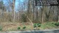
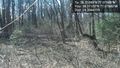
Anyway getting to the spot was fairly straightforward, pulled off on the side of the road and went crashing into the underbrush. Got stuck with these thorny vines (they are everywhere in this area, have had to deal with them on every offroad expedition) and finally into the woods. I found a narrow track which led me part of the way there, then through the brush again.
I went back to my car and decided to drive on the narrow dirt track to see where it went. It ended near a swamp--I assume it's used infrequently by hunters.
Left and headed to pick up Allison for the Cumberland, MD hashpoint expedition.
Tracklog
Photos
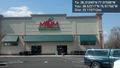
Traffic is terrible and I'm starving @38.6222,-76.9177
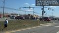
Really bad car accident I saw on the way there @38.5389,-76.9842
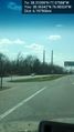
Huge power plant or fuel depot at the Potomac River @38.3634,-76.9832
The view from the street 500 ft away @38.3108,-77.0777
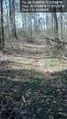
came upon a narrow car pass in the woods @38.3109,-77.0763

Silly grin @38.3110,-77.0759
The view @38.3110,-77.0759
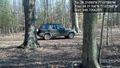
I decided to try to drive on that little car track in this is the end of the car track @38.3116,-77.0727


Achievements
OfficeLinebacker earned the Tron achievement
|
OfficeLinebacker earned the Consecutive geohash achievement
|