Difference between revisions of "2013-04-01 46 11"
imported>Werther (Created page with "{{subst:Expedition |lat = 46 |lon = 11 |date = 2013-04-01 }}") |
m (Location correction) |
||
| (3 intermediate revisions by 2 users not shown) | |||
| Line 18: | Line 18: | ||
__NOTOC__ | __NOTOC__ | ||
== Location == | == Location == | ||
| − | + | In the woods west of Sopramonte, Mt.Bondone, Trento. | |
== Participants == | == Participants == | ||
| − | + | ||
| − | + | [[User:Werther|Werther]] | |
== Plans == | == Plans == | ||
| − | + | ||
| + | I didn't notice Monday's hash was so close to Trento until early afternoon, so this wasn't exactly planned. | ||
| + | |||
| + | My last expedition to [[2013-03-30 46 11|Segno]] taught me to always think for a plan B when geohashing, so I studied two different paths to reach the hashpoint, one from Sopramonte and one from Baselga. | ||
| + | |||
| + | Despite not being too close to the city centre, both villages are included in Trento's municipality and thus reachable by the city bus network rather than intercity coaches. That was good, because it meant regular timetables while coaches have pretty sparse running times on Sundays and holidays. Bus no.6 reaches Sopramonte once an hour, and that time looked enough to reach the hashpoint both from Baselga and Sopramonte. | ||
== Expedition == | == Expedition == | ||
| − | |||
| − | + | While I had been leaning towards the Sopramonte path- mostly because I had been there before, in the end I decided to take the road from Baselga, simply because that allowed me for a bit more time and the road from there looked shorter, on paper. It was the best thing to do- I had never been to Baselga despite living less than 10 kms away from there, and it's always nice to get to some new places while geohashing. Also, the expedition required more time than I thought, so the 10 minutes I saved by getting off the bus before the Sopramonte terminus proved precious. | |
| − | + | ||
| + | Once I walked through the small village, the road started to go fairly uphill, until I got to a couple country houses, where the paved road ended and a muddy path began. That was my last landmark- I only had to rely on my GPS from there. Luckily I was near Trento so I was able to orientate a bit by myself, but finding the exact place proved to be quite a challenge. It was the first time (apart from the failed Cinte expedition [[2013-01-02 46 11|earlier this year]]) that I was hashing without exactly knowing what to expect, so it was particularly exciting. I had to walk down a steep cliffside to get to the hashpoint, but I was able to do that without getting hurt so all for the good. I spent a lot of time there trying to understand where the hashpoint was (the GPS reception wasn't the best) and in the end I came to the conclusion that it fell right next to the palce where some carnivorous animal had feasted on a poor bunny. It was a very wicked turn of events indeed; the algorhythm proved to have a very bad sense of humour. | ||
| + | |||
| + | Anyways, after I took the photos, I noticed that it was too late to try to take the bus from Sopramonte, so I took the same road as before and arrived in Baselga a few minutes before the bus came. | ||
== Photos == | == Photos == | ||
| Line 38: | Line 45: | ||
--> | --> | ||
<gallery perrow="5"> | <gallery perrow="5"> | ||
| + | Image:20130401 Sopramonte 001.jpg| The bus leaving Baselga | ||
| + | Image:20130104 Sopramonte 002.jpg| The road starts to go uphill... torture from now on... | ||
| + | Image:20130401 Sopramonte 003.jpg| Stunning alpine meadows | ||
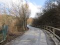
| + | Image:20130401 Sopramonte 004.jpg| The road ends, an unpaved path begins... | ||
| + | Image:20130401 Sopramonte 005.jpg| I chose to enter the woods following the path left from some trucks involved in recent deforestation works | ||
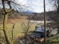
| + | Image:20130401 Sopramonte 006.jpg| The hashpoint was somewhere below there | ||
| + | Image:20130401 Sopramonte 007.jpg| (almost perfect) coords! | ||
| + | Image:20130401 Sopramonte 008.jpg| Stupid grin time! Now with glasses. | ||
| + | Image:20130401 Sopramonte 009.jpg| The tree next to the poor bunny, whom I chose not to photograph (IT WAS A DEAD BUNNY FOR GOD'S SAKE POSSIBLY THE SADDEST THING ON EARTH) | ||
| + | Image:20130401 Sopramonte 010.jpg| This reminded me of the Bingo Players video and I shivered in fear | ||
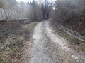
| + | Image:20130401 Sopramonte 011.jpg| The same road as picture 2, just downhill. Needless to say, a completely different story... | ||
| + | Image:20130401 Sopramonte 012.jpg| The village of Baselga from above | ||
| + | |||
</gallery> | </gallery> | ||
| − | |||
| − | |||
| − | |||
| − | |||
| − | |||
| − | |||
| − | |||
| − | |||
| − | |||
| − | |||
| − | |||
| − | |||
| − | |||
| − | |||
| − | |||
| − | |||
[[Category:Expeditions]] | [[Category:Expeditions]] | ||
| − | |||
[[Category:Expeditions with photos]] | [[Category:Expeditions with photos]] | ||
| − | |||
| − | |||
| − | |||
| − | |||
| − | |||
[[Category:Coordinates reached]] | [[Category:Coordinates reached]] | ||
| − | + | {{location|IT|TT}} | |
| − | |||
| − | |||
| − | |||
| − | |||
| − | |||
| − | |||
| − | |||
| − | |||
| − | |||
| − | |||
| − | |||
| − | |||
| − | |||
| − | |||
| − | |||
| − | |||
| − | |||
Latest revision as of 15:09, 28 July 2021
| Mon 1 Apr 2013 in 46,11: 46.0690692, 11.0406531 geohashing.info google osm bing/os kml crox |
Location
In the woods west of Sopramonte, Mt.Bondone, Trento.
Participants
Plans
I didn't notice Monday's hash was so close to Trento until early afternoon, so this wasn't exactly planned.
My last expedition to Segno taught me to always think for a plan B when geohashing, so I studied two different paths to reach the hashpoint, one from Sopramonte and one from Baselga.
Despite not being too close to the city centre, both villages are included in Trento's municipality and thus reachable by the city bus network rather than intercity coaches. That was good, because it meant regular timetables while coaches have pretty sparse running times on Sundays and holidays. Bus no.6 reaches Sopramonte once an hour, and that time looked enough to reach the hashpoint both from Baselga and Sopramonte.
Expedition
While I had been leaning towards the Sopramonte path- mostly because I had been there before, in the end I decided to take the road from Baselga, simply because that allowed me for a bit more time and the road from there looked shorter, on paper. It was the best thing to do- I had never been to Baselga despite living less than 10 kms away from there, and it's always nice to get to some new places while geohashing. Also, the expedition required more time than I thought, so the 10 minutes I saved by getting off the bus before the Sopramonte terminus proved precious.
Once I walked through the small village, the road started to go fairly uphill, until I got to a couple country houses, where the paved road ended and a muddy path began. That was my last landmark- I only had to rely on my GPS from there. Luckily I was near Trento so I was able to orientate a bit by myself, but finding the exact place proved to be quite a challenge. It was the first time (apart from the failed Cinte expedition earlier this year) that I was hashing without exactly knowing what to expect, so it was particularly exciting. I had to walk down a steep cliffside to get to the hashpoint, but I was able to do that without getting hurt so all for the good. I spent a lot of time there trying to understand where the hashpoint was (the GPS reception wasn't the best) and in the end I came to the conclusion that it fell right next to the palce where some carnivorous animal had feasted on a poor bunny. It was a very wicked turn of events indeed; the algorhythm proved to have a very bad sense of humour.
Anyways, after I took the photos, I noticed that it was too late to try to take the bus from Sopramonte, so I took the same road as before and arrived in Baselga a few minutes before the bus came.
Photos
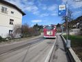
The bus leaving Baselga
The road starts to go uphill... torture from now on...
Stunning alpine meadows
The road ends, an unpaved path begins...
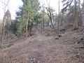
I chose to enter the woods following the path left from some trucks involved in recent deforestation works
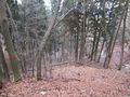
The hashpoint was somewhere below there
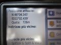
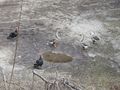
(almost perfect) coords!
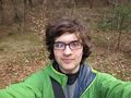
Stupid grin time! Now with glasses.
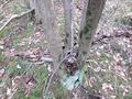
The tree next to the poor bunny, whom I chose not to photograph (IT WAS A DEAD BUNNY FOR GOD'S SAKE POSSIBLY THE SADDEST THING ON EARTH)
This reminded me of the Bingo Players video and I shivered in fear
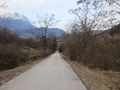
The same road as picture 2, just downhill. Needless to say, a completely different story...
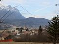
The village of Baselga from above


