Difference between revisions of "2013-04-02 47 -122"
imported>Thomcat ([live picture] Tolt pipeline trail SE facing [http://www.openstreetmap.org/?lat=47.71982661&lon=-122.01655076&zoom=16&layers=B000FTF @47.7198,-122.0166]) |
imported>FippeBot m (Location) |
||
| (3 intermediate revisions by one other user not shown) | |||
| Line 18: | Line 18: | ||
== Expedition == | == Expedition == | ||
| − | + | *On my way - eta 4:10 pm -- [[User:Thomcat|Thomcat]] ([[User talk:Thomcat|talk]]) [http://www.openstreetmap.org/?lat=47.76184488&lon=-122.13159577&zoom=16&layers=B000FTF @47.7618,-122.1316] 15:43, 2 April 2013 (PDT) | |
| + | A bit of a winding drive, and very much the wrong way from home, but worth it for a geohash! I saw a few spots where one might hike a bit to see over the bluff, but it also looked like private property, so I demured. I crossed the Tolt Pipeline trail (really an access road - though the evidence of plenty of horses indicates it is multi-use) and soon arrived on the spot. | ||
| − | * | + | *Here we are! -- [[User:Thomcat|Thomcat]] ([[User talk:Thomcat|talk]]) [http://www.openstreetmap.org/?lat=47.71802577&lon=-122.01663701&zoom=16&layers=B000FTF @47.7180,-122.0166] 16:04, 2 April 2013 (PDT) |
| − | + | I got out, snapped a few pics, and completely forgot to chalk the pavement. Rain threatening (which only happens here in months that have 3 or more letters), I decided to head for home. No meetup, but +1 success! | |
| − | |||
| − | |||
== Photos == | == Photos == | ||
| − | |||
| − | |||
| − | |||
<gallery perrow="5"> | <gallery perrow="5"> | ||
| + | Image:2013-04-02 47 -122 DriveInSpot.jpg | Parked on the spot | ||
Image:2013-04-02_47_-122_16-06-14-993.jpg | On the spot [http://www.openstreetmap.org/?lat=47.71804146&lon=-122.01663151&zoom=16&layers=B000FTF @47.7180,-122.0166] | Image:2013-04-02_47_-122_16-06-14-993.jpg | On the spot [http://www.openstreetmap.org/?lat=47.71804146&lon=-122.01663151&zoom=16&layers=B000FTF @47.7180,-122.0166] | ||
| Line 38: | Line 35: | ||
Image:2013-04-02_47_-122_16-11-25-127.jpg | Tolt pipeline trail SE facing [http://www.openstreetmap.org/?lat=47.71982661&lon=-122.01655076&zoom=16&layers=B000FTF @47.7198,-122.0166] | Image:2013-04-02_47_-122_16-11-25-127.jpg | Tolt pipeline trail SE facing [http://www.openstreetmap.org/?lat=47.71982661&lon=-122.01655076&zoom=16&layers=B000FTF @47.7198,-122.0166] | ||
| + | |||
| + | Image:2013-04-02_47_-122_16-12-21-373.jpg | Tolt trail NW facing [http://www.openstreetmap.org/?lat=47.71982503&lon=-122.01655171&zoom=16&layers=B000FTF @47.7198,-122.0166] | ||
</gallery> | </gallery> | ||
| − | |||
| − | |||
| − | |||
| − | |||
| − | |||
| − | |||
| − | |||
[[Category:Expeditions]] | [[Category:Expeditions]] | ||
[[Category:Expeditions with photos]] | [[Category:Expeditions with photos]] | ||
| − | |||
| − | |||
[[Category:Coordinates reached]] | [[Category:Coordinates reached]] | ||
| − | + | {{location|US|WA|KN}} | |
| − | |||
| − | |||
| − | |||
| − | |||
Latest revision as of 01:43, 14 August 2019
| Tue 2 Apr 2013 in Seattle: 47.7180351, -122.0166102 geohashing.info google osm bing/os kml crox |
Location
Off 242nd Ave in Redmond, near the top of the bluff overlooking Duvall. Just south of the Tolt Pipeline Trail.
Participants
Plans
Stop by after work, roughly 4:30.
Expedition
- On my way - eta 4:10 pm -- Thomcat (talk) @47.7618,-122.1316 15:43, 2 April 2013 (PDT)
A bit of a winding drive, and very much the wrong way from home, but worth it for a geohash! I saw a few spots where one might hike a bit to see over the bluff, but it also looked like private property, so I demured. I crossed the Tolt Pipeline trail (really an access road - though the evidence of plenty of horses indicates it is multi-use) and soon arrived on the spot.
- Here we are! -- Thomcat (talk) @47.7180,-122.0166 16:04, 2 April 2013 (PDT)
I got out, snapped a few pics, and completely forgot to chalk the pavement. Rain threatening (which only happens here in months that have 3 or more letters), I decided to head for home. No meetup, but +1 success!
Photos
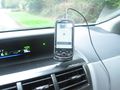
Parked on the spot

On the spot @47.7180,-122.0166
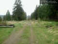
Tolt pipeline trail SE facing @47.7198,-122.0166
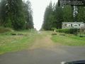
Tolt trail NW facing @47.7198,-122.0166


