Difference between revisions of "2013-04-08 46 11"
imported>Werther (Created page with "{{subst:Expedition |lat = 46 |lon = 11 |date = 2013-04-08 }}") |
m (Location correction) |
||
| (4 intermediate revisions by 3 users not shown) | |||
| Line 15: | Line 15: | ||
}} | }} | ||
| − | + | ||
__NOTOC__ | __NOTOC__ | ||
== Location == | == Location == | ||
| − | + | On the north-bound lane of SP71, between Civezzano and Torchio. | |
== Participants == | == Participants == | ||
| − | + | * [[User:Werther]] | |
| − | |||
== Plans == | == Plans == | ||
| − | + | ||
| + | Likely to be an evening hash. Leaving home at 17.20, getting a bus to Civezzano (20 mins trip) and walking to the hashpoint from there. There is an awesomely timed bus to Trento at 18.29 which also stops at Maso Zandonà (closer to the hashpoint than Civezzano). | ||
| + | |||
| + | Should be an easy one, but obtaining complete proof is probably out of the question as it would imply standing in the middle of a fairly busy road. I will probably settle for a Googlemapsesque picture from the roadside. | ||
| + | |||
| + | If the weather was beautiful enough (highly unlikely) and if I was able to get a bike (mine was stolen time ago), I might bike there- it's around 7km from my house. I'll see tomorrow. | ||
== Expedition == | == Expedition == | ||
| − | |||
| − | + | Fairly easy, with no major events really. Left home earlier to ensure a stop at the comic shop in the city centre, then headed to the station from where I took the coach to Civezzano. The weather was worse than predicted- it actually rained and it was pretty windy. Still better than my recent expedition to [[2013-03-30 46 11|Segno]] though. | |
| − | + | ||
| + | Arrived on time, took SP71 from Civezzano and walked my way to the hashpoint. The road wasn't busy, despite being the time when commuters come home from work. Still, I didn't felt like standing in the middle of the road looking for the perfect hashpoint- the Streetviewesque picture I promised clearly shows I got there, and it's enough proof to me. | ||
| + | |||
| + | The wind got worse on my way back to Civezzano, and I actually ended up wetter than in Segno as the umbrella was almost pointless. The return trip proved as problem-free as the rest of the hash. | ||
== Photos == | == Photos == | ||
| − | |||
| − | |||
| − | |||
<gallery perrow="5"> | <gallery perrow="5"> | ||
| + | Image:20130408 Civezzano 001.jpg|The bus leaving Civezzano, bound to alpine resort town Cavalese | ||
| + | Image:20130408 Civezzano 002.jpg|SP71 outside Civezzano. Still houses... | ||
| + | Image:20130408 Civezzano 003.jpg|...which slowly leave place to meadows and fields | ||
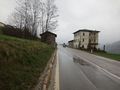
| + | Image:20130408 Civezzano 004.jpg|The hashpoint, from the left side of the road | ||
| + | Image:20130408 Civezzano 005.jpg|Snapshot while quickly crossing the road | ||
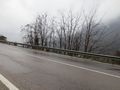
| + | Image:20130408 Civezzano 006.jpg|The hashpoint from east | ||
| + | Image:20130408 Civezzano 007.jpg|The wind can't stop me! | ||
</gallery> | </gallery> | ||
== Achievements == | == Achievements == | ||
| − | |||
| − | |||
| − | |||
| − | |||
| − | |||
| − | + | {{Land geohash | latitude = 46 | longitude = 11 | date = 2013-04-08 | name = Werther }} | |
| − | + | ||
| − | + | {{Drowned rat geohash | latitude = 46 | longitude = 11 | date = 2013-04-08 | name = Werther | reason = geohashing through significant rain and wind }} | |
| − | + | (I'm claiming it this time: getting sick of hashing through water!) | |
| − | |||
[[Category:Expeditions]] | [[Category:Expeditions]] | ||
| − | |||
[[Category:Expeditions with photos]] | [[Category:Expeditions with photos]] | ||
| − | [[Category: | + | [[Category:Coordinates reached]] |
[[Category:Expedition without GPS]] | [[Category:Expedition without GPS]] | ||
| − | + | {{location|IT|TT}} | |
| − | |||
| − | |||
| − | |||
| − | |||
| − | |||
| − | |||
| − | |||
| − | |||
| − | |||
| − | |||
| − | |||
| − | |||
| − | |||
| − | |||
| − | |||
| − | |||
| − | |||
| − | |||
| − | |||
| − | |||
| − | |||
Latest revision as of 15:09, 28 July 2021
| Mon 8 Apr 2013 in 46,11: 46.0864534, 11.1953261 geohashing.info google osm bing/os kml crox |
Location
On the north-bound lane of SP71, between Civezzano and Torchio.
Participants
Plans
Likely to be an evening hash. Leaving home at 17.20, getting a bus to Civezzano (20 mins trip) and walking to the hashpoint from there. There is an awesomely timed bus to Trento at 18.29 which also stops at Maso Zandonà (closer to the hashpoint than Civezzano).
Should be an easy one, but obtaining complete proof is probably out of the question as it would imply standing in the middle of a fairly busy road. I will probably settle for a Googlemapsesque picture from the roadside.
If the weather was beautiful enough (highly unlikely) and if I was able to get a bike (mine was stolen time ago), I might bike there- it's around 7km from my house. I'll see tomorrow.
Expedition
Fairly easy, with no major events really. Left home earlier to ensure a stop at the comic shop in the city centre, then headed to the station from where I took the coach to Civezzano. The weather was worse than predicted- it actually rained and it was pretty windy. Still better than my recent expedition to Segno though.
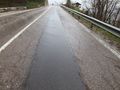
Arrived on time, took SP71 from Civezzano and walked my way to the hashpoint. The road wasn't busy, despite being the time when commuters come home from work. Still, I didn't felt like standing in the middle of the road looking for the perfect hashpoint- the Streetviewesque picture I promised clearly shows I got there, and it's enough proof to me.
The wind got worse on my way back to Civezzano, and I actually ended up wetter than in Segno as the umbrella was almost pointless. The return trip proved as problem-free as the rest of the hash.
Photos
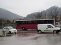
The bus leaving Civezzano, bound to alpine resort town Cavalese
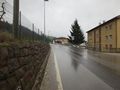
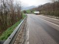
SP71 outside Civezzano. Still houses...
...which slowly leave place to meadows and fields
The hashpoint, from the left side of the road
Snapshot while quickly crossing the road
The hashpoint from east
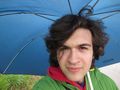
The wind can't stop me!


Achievements
Werther earned the Land geohash achievement
|
Werther earned the Drowned Rat Geohash Achievement
|
(I'm claiming it this time: getting sick of hashing through water!)