Difference between revisions of "2013-04-14 52 -1"
From Geohashing
imported>Sourcerer m ([live] Arrived.) |
imported>Sourcerer (→New expedition by Sourcerer) |
||
| Line 1: | Line 1: | ||
| − | |||
| − | |||
| − | |||
| − | |||
| − | |||
| − | |||
| − | |||
| − | |||
| − | |||
| − | |||
{{meetup graticule | {{meetup graticule | ||
| lat=52 | | lat=52 | ||
| Line 15: | Line 5: | ||
}} | }} | ||
| − | |||
| − | |||
== Location == | == Location == | ||
| − | + | On the banks of the river Blythe between the M6 Toll road and the A446, east of Birmingham, UK. | |
== Participants == | == Participants == | ||
| − | + | [[User:Sourcerer|Sourcerer]] | |
| − | |||
| − | |||
| − | |||
| − | |||
== Expedition == | == Expedition == | ||
| − | + | *Arrived. -- [[User:Sourcerer|Sourcerer]] ([[User talk:Sourcerer|talk]]) [http://www.openstreetmap.org/?lat=52.52394497394562&lon=-1.7271441221237183&zoom=16&layers=B000FTF @52.5239,-1.7271] 13:12, 14 April 2013 (GMT+01:00) | |
| − | |||
| − | + | This was success two of five attempts today. After a weekend of beer and curry with good friends, the journey home crossed five graticules. The winter weather had finally given way to April sun with gusty winds but it was much warmer and pleasant to be out and about. This hashpoint was on a riverside public footpath. Sadly it was litter strewn and looked unloved. The M6 Toll road towered above the footpath and dominated the scene. The river and bridge were nice though. | |
| − | |||
| − | |||
== Photos == | == Photos == | ||
| − | < | + | <gallery perrow="4"> |
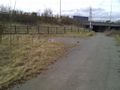
| − | Image: | + | Image:2013-04-14_52_-1_Sourcerer_1.jpg | The Hashpoint |
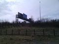
| − | -- | + | Image:2013-04-14_52_-1_Sourcerer_2.jpg | The Hashpoint |
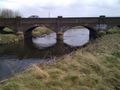
| − | + | Image:2013-04-14_52_-1_Sourcerer_3.jpg | The Hashpoint | |
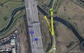
| + | Image:2013-04-14_52_-1_Sourcerer_4.jpg | Tracklog | ||
</gallery> | </gallery> | ||
| − | |||
| − | |||
| − | |||
| − | |||
| − | |||
| − | |||
| − | |||
| − | |||
| − | |||
| − | |||
| − | |||
| − | |||
| − | |||
| − | |||
| − | |||
[[Category:Expeditions]] | [[Category:Expeditions]] | ||
| − | |||
[[Category:Expeditions with photos]] | [[Category:Expeditions with photos]] | ||
| − | |||
| − | |||
| − | |||
| − | |||
| − | |||
[[Category:Coordinates reached]] | [[Category:Coordinates reached]] | ||
| − | |||
| − | |||
| − | |||
| − | |||
| − | |||
| − | |||
| − | |||
| − | |||
| − | |||
| − | |||
| − | |||
| − | |||
| − | |||
| − | |||
| − | |||
| − | |||
| − | |||
| − | |||
Revision as of 20:25, 14 April 2013
| Sun 14 Apr 2013 in 52,-1: 52.5239406, -1.7271735 geohashing.info google osm bing/os kml crox |
Contents
Location
On the banks of the river Blythe between the M6 Toll road and the A446, east of Birmingham, UK.
Participants
Expedition
- Arrived. -- Sourcerer (talk) @52.5239,-1.7271 13:12, 14 April 2013 (GMT+01:00)
This was success two of five attempts today. After a weekend of beer and curry with good friends, the journey home crossed five graticules. The winter weather had finally given way to April sun with gusty winds but it was much warmer and pleasant to be out and about. This hashpoint was on a riverside public footpath. Sadly it was litter strewn and looked unloved. The M6 Toll road towered above the footpath and dominated the scene. The river and bridge were nice though.
Photos
The Hashpoint
The Hashpoint
The Hashpoint
Tracklog


