Difference between revisions of "2013-04-15 43 -116"
imported>Eldin ([live picture] Looking east from hashpoint. [http://www.openstreetmap.org/?lat=43.81440000&lon=-116.63600000&zoom=16&layers=B000FTF @43.8144,-116.6360]) |
imported>Eldin (fill in expedition details.) |
||
| Line 1: | Line 1: | ||
| − | |||
| − | |||
| − | |||
| − | |||
| − | |||
| − | |||
| − | |||
| − | |||
| − | |||
| − | |||
{{meetup graticule | {{meetup graticule | ||
| lat=43 | | lat=43 | ||
| Line 15: | Line 5: | ||
}} | }} | ||
| − | |||
__NOTOC__ | __NOTOC__ | ||
== Location == | == Location == | ||
| − | + | On Alta Vista Rd, north of Middleton. | |
== Participants == | == Participants == | ||
| − | + | *[[User:Eldin|Eldin]] | |
| − | |||
== Plans == | == Plans == | ||
| − | + | Today's coordinates are very reachable, and it should be possible to get the speed racer achievement since it looks like they're right on the road. | |
| + | |||
== Expedition == | == Expedition == | ||
| − | + | After getting home from work, I headed out towards today's coordinates. I called a friend who lives near the coordinates to invite him along, but he was unfortunately busy. I arrived at the spot just after 8pm. The hashpoint was located near the center of the road, and I drove through it 3 times in all. The first time, I drove through (or at least within GPS tolerance) at about 10MPH, to find the exact spot. Then I parked my car, got out, and snapped a couple of pictures. | |
| + | |||
| + | Then I got back in my car, got turned around, and headed back to go through the hashpoint at 35+MPH (the speed limit). I succeeded going through the hash at speed, but failed to get a decent picture. So I turned around and tried it again. The 3rd (and last) time driving through the hash I managed to get a picture showing the speedometer (at about 38MPH) and the GPS about 14ft from the coordinates, which I submit as proof for the [[Speed Racer]] achievement. | ||
| Line 34: | Line 25: | ||
*Speed racer achieved. -- [[User:Eldin|Eldin]] ([[User talk:Eldin|talk]]) [http://www.openstreetmap.org/?lat=43.81181378&lon=-116.63595572&zoom=16&layers=B000FTF @43.8118,-116.6360] 20:08, 15 April 2013 (MDT) | *Speed racer achieved. -- [[User:Eldin|Eldin]] ([[User talk:Eldin|talk]]) [http://www.openstreetmap.org/?lat=43.81181378&lon=-116.63595572&zoom=16&layers=B000FTF @43.8118,-116.6360] 20:08, 15 April 2013 (MDT) | ||
| + | |||
== Tracklog == | == Tracklog == | ||
| − | + | A tracklog for part of the expedition was saved, and can be provided if anyone wants it. | |
== Photos == | == Photos == | ||
| − | |||
| − | |||
| − | |||
<gallery perrow="5"> | <gallery perrow="5"> | ||
Image:2013-04-15_43_-116_20-11-46-273.jpg | Silly grin. | Image:2013-04-15_43_-116_20-11-46-273.jpg | Silly grin. | ||
| − | Image:2013-04-15_43_-116_20-13-37-670.jpg | Looking east from hashpoint. | + | Image:2013-04-15_43_-116_20-13-37-670.jpg | Looking east from hashpoint. |
| + | |||
| + | File:2013-04-15 43 -116 speed racer.jpg | Go speed racer go! | ||
</gallery> | </gallery> | ||
== Achievements == | == Achievements == | ||
{{#vardefine:ribbonwidth|800px}} | {{#vardefine:ribbonwidth|800px}} | ||
| − | + | {{Speed racer | |
| − | + | | latitude = 43 | |
| + | | longitude = -116 | ||
| + | | date = 2013-04-15 | ||
| + | | name = [[User:Eldin|Eldin]] | ||
| + | | speed = 38MPH | ||
| + | }} | ||
| − | |||
| − | |||
| − | |||
| − | |||
| − | |||
| − | |||
| − | |||
| − | |||
[[Category:Expeditions]] | [[Category:Expeditions]] | ||
| − | |||
[[Category:Expeditions with photos]] | [[Category:Expeditions with photos]] | ||
| − | |||
| − | |||
| − | |||
| − | |||
| − | |||
[[Category:Coordinates reached]] | [[Category:Coordinates reached]] | ||
| − | |||
| − | |||
| − | |||
| − | |||
| − | |||
| − | |||
| − | |||
| − | |||
| − | |||
| − | |||
| − | |||
| − | |||
| − | |||
| − | |||
| − | |||
| − | |||
| − | |||
| − | |||
Revision as of 04:00, 16 April 2013
| Mon 15 Apr 2013 in 43,-116: 43.8144168, -116.6364540 geohashing.info google osm bing/os kml crox |
Location
On Alta Vista Rd, north of Middleton.
Participants
Plans
Today's coordinates are very reachable, and it should be possible to get the speed racer achievement since it looks like they're right on the road.
Expedition
After getting home from work, I headed out towards today's coordinates. I called a friend who lives near the coordinates to invite him along, but he was unfortunately busy. I arrived at the spot just after 8pm. The hashpoint was located near the center of the road, and I drove through it 3 times in all. The first time, I drove through (or at least within GPS tolerance) at about 10MPH, to find the exact spot. Then I parked my car, got out, and snapped a couple of pictures.
Then I got back in my car, got turned around, and headed back to go through the hashpoint at 35+MPH (the speed limit). I succeeded going through the hash at speed, but failed to get a decent picture. So I turned around and tried it again. The 3rd (and last) time driving through the hash I managed to get a picture showing the speedometer (at about 38MPH) and the GPS about 14ft from the coordinates, which I submit as proof for the Speed Racer achievement.
- Coordinates reached. Now to get Speed Racer achievement. -- Eldin (talk) @43.8143,-116.6359 20:02, 15 April 2013 (MDT)
- Speed racer achieved. -- Eldin (talk) @43.8118,-116.6360 20:08, 15 April 2013 (MDT)
Tracklog
A tracklog for part of the expedition was saved, and can be provided if anyone wants it.
Photos

Silly grin.
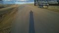
Looking east from hashpoint.
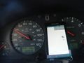
Go speed racer go!


Achievements
