Difference between revisions of "2013-04-21 17 78"
imported>Root2 (→Tracklog) |
m (per Renaming Proposal) |
||
| (10 intermediate revisions by 3 users not shown) | |||
| Line 1: | Line 1: | ||
| − | |||
| − | |||
| − | |||
| − | |||
| − | |||
| − | |||
| − | |||
| − | |||
| − | |||
| − | |||
{{meetup graticule | {{meetup graticule | ||
| lat=17 | | lat=17 | ||
| Line 15: | Line 5: | ||
}} | }} | ||
| − | |||
__NOTOC__ | __NOTOC__ | ||
== Location == | == Location == | ||
| − | |||
Near a beautiful lake in an empty field. | Near a beautiful lake in an empty field. | ||
== Participants == | == Participants == | ||
| − | + | ||
| − | + | * Mohit Kharb | |
| + | * Gurupreet | ||
| + | * Sneha Magapu | ||
| + | * Lokesh | ||
| + | * Puneet | ||
| + | * Prashant Poladia | ||
| + | * Saurav Panwar | ||
| + | * Jagjeet | ||
| + | * Aman Deep | ||
| + | * Ruturaj Dhekane [[User:Root2|Root2]] | ||
== Plans == | == Plans == | ||
| − | + | The plan was a randomness Meetup by the Great Hyderabad Adventure Club. More information about how the meetup was planned is located here. | |
| + | [http://meetup.ghac.in/events/114947492/ Geohashing - the adventure in randomness ] | ||
== Expedition == | == Expedition == | ||
| − | |||
We met at 6AM and identified the coordinates. The location was | We met at 6AM and identified the coordinates. The location was | ||
N17.645586°, E78.360199°. | N17.645586°, E78.360199°. | ||
| Line 43: | Line 40: | ||
Sweet smell of rain marked the end of the hike and GeoHash. | Sweet smell of rain marked the end of the hike and GeoHash. | ||
| − | == Tracklog == | + | All photos taken are uploaded here - [http://www.meetup.com/great-hyderabad-adventure-club/photos/14457712/ Meetup photo page] |
| + | <!--== Tracklog == | ||
<!-- if your GPS device keeps a log, you may post a link here --> | <!-- if your GPS device keeps a log, you may post a link here --> | ||
| − | == Photos == | + | == Photos == |
| + | <gallery perrow="5"> | ||
| + | File:2013-04-21 17 78 Thats it. Thats where we have to be..jpeg | All geohashers checking whether we have reached the right point. | ||
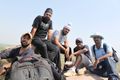
| + | File:2013-04-21 17 78 All geohashers together..jpeg | All in one frame. | ||
| + | File:2013-04-21 17 78 Mohit with GPS at point..jpeg | Mohit with the Conch shell and GPS. | ||
| + | File:2013-04-21 17 78 Bikes next to the lake..jpeg | Bikes parked near the lake. | ||
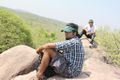
| + | File:2013-04-21 17 78 narsapur mountain.jpeg | After reaching the highest point in narsapur forest. | ||
| + | File:2013-04-21 17 78 On Top Of Mountain.jpeg | On Top most point in narsapur Forest. | ||
| + | </gallery> | ||
| + | |||
| + | |||
<!-- Insert pictures between the gallery tags using the following format: | <!-- Insert pictures between the gallery tags using the following format: | ||
Image:2012-##-## ## ## Alpha.jpg | Witty Comment | Image:2012-##-## ## ## Alpha.jpg | Witty Comment | ||
--> | --> | ||
| − | |||
| − | |||
== Achievements == | == Achievements == | ||
{{#vardefine:ribbonwidth|800px}} | {{#vardefine:ribbonwidth|800px}} | ||
| − | |||
| + | {{land geohash | ||
| + | | latitude = 17 | ||
| + | | longitude = 78 | ||
| + | | date = 2013-04-21 | ||
| + | | name = 10 members of the Great Hyderabad Adventure Club | ||
| + | }} | ||
| − | + | {{Graticule unlocked | |
| − | + | | latitude = 17 | |
| − | + | | longitude = 78 | |
| + | | date = 2013-04-21 | ||
| + | | name = 10 members of the Great Hyderabad Adventure Club | ||
| + | }} | ||
| − | + | {{Largest Geohash | |
| − | + | | latitude = 17 | |
| − | + | | longitude = 78 | |
| − | + | | date = 2013-04-21 | |
| + | | number = 10 | ||
| + | | name = 10 members of the Great Hyderabad Adventure Club | ||
| + | | graticule = Hyderabad, India | ||
| + | }} | ||
| − | |||
[[Category:Expeditions]] | [[Category:Expeditions]] | ||
| − | |||
| − | |||
| − | |||
| − | |||
| − | |||
| − | |||
| − | |||
[[Category:Coordinates reached]] | [[Category:Coordinates reached]] | ||
| − | + | {{location|IN|TG}} | |
| − | |||
| − | |||
| − | |||
| − | |||
| − | |||
| − | |||
| − | |||
| − | |||
| − | |||
| − | |||
| − | |||
| − | |||
| − | |||
| − | |||
| − | |||
| − | |||
| − | |||
Latest revision as of 05:26, 20 March 2024
| Sun 21 Apr 2013 in 17,78: 17.6455865, 78.3601992 geohashing.info google osm bing/os kml crox |
Location
Near a beautiful lake in an empty field.
Participants
- Mohit Kharb
- Gurupreet
- Sneha Magapu
- Lokesh
- Puneet
- Prashant Poladia
- Saurav Panwar
- Jagjeet
- Aman Deep
- Ruturaj Dhekane Root2
Plans
The plan was a randomness Meetup by the Great Hyderabad Adventure Club. More information about how the meetup was planned is located here. Geohashing - the adventure in randomness
Expedition
We met at 6AM and identified the coordinates. The location was N17.645586°, E78.360199°.
The team of 10 drove along the road towards Bonthapally and took a left turn into the open fields where the coordinate was located.We reached a beautiful looking lake where we parked the bikes and went geohash hunting. With multiple persons using GPS devices and going North and East and Puneet and Saurav leading ahead we finally reached the destination. The location was verified by a real GPS device also. It was a piece of land as empty as the place around.
Mohit placed a Shankha (Conch Shell) to mark its existence for any future excavations.
From there, unable to take a bath in the lake since the water was dirty, we moved towards Narsapur Forest range with Mohit leading. There Sneha and Lokesh decided to head back and Rest eight of us Mohit, Puneet, Jagjeet, Aman, Saurav, Prashant, Gurupreet and Ruturaj decided to climb the small hill which had rocks on the top.
After a quick climb followed by Sandwiches and bananas left behind by Sneha for us, we headed back towards Hyderabad. Under scorching heat, Prashant's aviator broke down. He luckily got a tempo which took the vehicle to Gandi Maisamma for repair. We continued into the Hyderabad city and went our ways.
Sweet smell of rain marked the end of the hike and GeoHash.
All photos taken are uploaded here - Meetup photo page
Photos
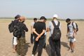
All geohashers checking whether we have reached the right point.
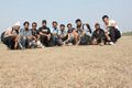
All in one frame.
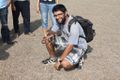
Mohit with the Conch shell and GPS.
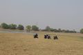
Bikes parked near the lake.
After reaching the highest point in narsapur forest.
On Top most point in narsapur Forest.


Achievements
10 members of the Great Hyderabad Adventure Club earned the Land geohash achievement
|
10 members of the Great Hyderabad Adventure Club earned the Graticule Unlocked Achievement
|
Hyderabad, India earned the Largest geohash achievement
|