Difference between revisions of "2013-04-21 42 -90"
imported>Swensonj (template) |
imported>FippeBot m (Location) |
||
| (One intermediate revision by one other user not shown) | |||
| Line 1: | Line 1: | ||
| − | |||
| − | |||
| − | |||
| − | |||
| − | |||
| − | |||
| − | |||
| − | |||
| − | |||
{{meetup graticule | {{meetup graticule | ||
| lat=42 | | lat=42 | ||
| Line 15: | Line 6: | ||
}} | }} | ||
| − | |||
__NOTOC__ | __NOTOC__ | ||
== Location == | == Location == | ||
| − | + | Red School Road, Lafayette County, Wisconsin, east of County Road H. | |
== Participants == | == Participants == | ||
| − | + | [[User:Swensonj|Swensonj]] ([[User talk:Swensonj|talk]]) and his wife, son, daughter, and English springer spaniel | |
| − | |||
== Plans == | == Plans == | ||
| − | + | We remembered to look up the hashpoint only late in the day, and ran out together about 6:15 p.m., in a hurry to beat sunset. | |
== Expedition == | == Expedition == | ||
| − | + | We piled into the van, and left town about 6:20. It was a pleasant with high wispy clouds -- a nice change after several days of rain mixed with snow. It looked like an easy trip: the drive to the hashpoint took only about 15 minutes, and the hashpoint was only about 20 meters off the side of the road. When we got there, though, we found our way blocked by a barbed-wire fence, and I didn't think crossing it without permission would set a good example for my kids. | |
| − | + | Happily, a young man was in the next driveway, with a boy and a girl, doing some kind of work on an ATV. I explained that I was on a scavenger hunt with my kids, and he was happy to give us permission to walk through his field for a few minutes. | |
| − | + | ||
| + | We stretched things out a bit by driving west to an access gate, then walking back east about 0.003 degrees. Finding the right location was easy, and everything seemed to have gone well -- then the camera ran out of batteries. I was able to get a quick shot of the GPS, and of our Grins, but didn't have the juice to keep trying for a GPS shot that was actually in focus. | ||
| + | |||
| + | We crossed the fence early on the way back, and collected a bag of litter along the roadside. We got back to the van, where we had some fresher batteries, and got a picture of some extremely shaggy cattle. A good-looking pheasant crossed the road in front of us as we drove back, too, but wouldn't wait for its close-up. | ||
| + | |||
| + | We celebrated a good trip with dinner at Culver's (a good fast-food spot), and got home about 8:15 p.m., ready to start writing this report and getting the kids into bed. | ||
== Photos == | == Photos == | ||
| − | |||
| − | |||
| − | |||
<gallery perrow="5"> | <gallery perrow="5"> | ||
| + | Image:2013-04-21 42 -90 Fence.jpg | They must have put this fence between the road and the hash by accident. | ||
| + | Image:2013-04-21 42 -90 Proof.jpg | We made it! [In case you can't read this, it says the right thing.] | ||
| + | Image:2013-04-21 42 -90 Grins.jpg | SwensonJ and kids; note litter in son's left hand. | ||
| + | Image:2013-04-21 42 -90 Family.jpg | SwensonJ's attractive and talented family | ||
| + | Image:2013-04-21 42 -90 Kine.jpg | Extremely shaggy cattle | ||
</gallery> | </gallery> | ||
== Achievements == | == Achievements == | ||
{{#vardefine:ribbonwidth|800px}} | {{#vardefine:ribbonwidth|800px}} | ||
| − | + | {{land geohash | |
| − | + | | latitude = 42 | |
| − | + | | longitude = -90 | |
| − | + | | date = 2013-04-21 | |
| − | + | | name = SwensonJ | |
| − | + | | image = 2013-04-21 42 -90 Proof.jpg | |
| − | + | }} | |
| − | + | {{Ambassador geohash | |
| − | + | | latitude = 42 | |
| − | + | | longitude = -90 | |
| − | + | | date = 2013-04-21 | |
| + | | name = SwensonJ | ||
| + | | image = 2013-04-21 42 -90 Fence.jpg | ||
| + | }} | ||
| + | {{Geotrash | ||
| + | | latitude = 42 | ||
| + | | longitude = -90 | ||
| + | | date = 2013-04-21 | ||
| + | | name = SwensonJ | ||
| + | }} | ||
| − | |||
[[Category:Expeditions]] | [[Category:Expeditions]] | ||
| − | |||
[[Category:Expeditions with photos]] | [[Category:Expeditions with photos]] | ||
| − | |||
| − | |||
| − | |||
| − | |||
| − | |||
[[Category:Coordinates reached]] | [[Category:Coordinates reached]] | ||
| − | + | {{location|US|WI|LF}} | |
| − | |||
| − | |||
| − | |||
| − | |||
| − | |||
| − | |||
| − | |||
| − | |||
| − | |||
| − | |||
| − | |||
| − | |||
| − | |||
| − | |||
| − | |||
| − | |||
| − | |||
Latest revision as of 05:51, 6 August 2019
| Sun 21 Apr 2013 in 42,-90: 42.6455865, -90.3601992 geohashing.info google osm bing/os kml crox |
Location
Red School Road, Lafayette County, Wisconsin, east of County Road H.
Participants
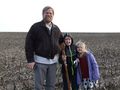
Swensonj (talk) and his wife, son, daughter, and English springer spaniel
Plans
We remembered to look up the hashpoint only late in the day, and ran out together about 6:15 p.m., in a hurry to beat sunset.
Expedition
We piled into the van, and left town about 6:20. It was a pleasant with high wispy clouds -- a nice change after several days of rain mixed with snow. It looked like an easy trip: the drive to the hashpoint took only about 15 minutes, and the hashpoint was only about 20 meters off the side of the road. When we got there, though, we found our way blocked by a barbed-wire fence, and I didn't think crossing it without permission would set a good example for my kids.
Happily, a young man was in the next driveway, with a boy and a girl, doing some kind of work on an ATV. I explained that I was on a scavenger hunt with my kids, and he was happy to give us permission to walk through his field for a few minutes.
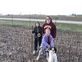
We stretched things out a bit by driving west to an access gate, then walking back east about 0.003 degrees. Finding the right location was easy, and everything seemed to have gone well -- then the camera ran out of batteries. I was able to get a quick shot of the GPS, and of our Grins, but didn't have the juice to keep trying for a GPS shot that was actually in focus.
We crossed the fence early on the way back, and collected a bag of litter along the roadside. We got back to the van, where we had some fresher batteries, and got a picture of some extremely shaggy cattle. A good-looking pheasant crossed the road in front of us as we drove back, too, but wouldn't wait for its close-up.
We celebrated a good trip with dinner at Culver's (a good fast-food spot), and got home about 8:15 p.m., ready to start writing this report and getting the kids into bed.
Photos
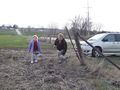
They must have put this fence between the road and the hash by accident.

We made it! [In case you can't read this, it says the right thing.]
SwensonJ and kids; note litter in son's left hand.
SwensonJ's attractive and talented family
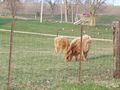
Extremely shaggy cattle


Achievements
SwensonJ earned the Land geohash achievement
|
SwensonJ earned the Ambassador achievement
|
SwensonJ earned the GeoTrash Geohash Achievement
|