Difference between revisions of "2013-04-21 43 -116"
imported>Eldin ([live picture] Silly grin. [http://www.openstreetmap.org/?lat=43.64560000&lon=-116.36000000&zoom=16&layers=B000FTF @43.6456,-116.3600]) |
imported>FippeBot m (Location) |
||
| (4 intermediate revisions by one other user not shown) | |||
| Line 1: | Line 1: | ||
| − | |||
| − | |||
| − | |||
| − | |||
| − | |||
| − | |||
| − | |||
| − | |||
| − | |||
| − | |||
{{meetup graticule | {{meetup graticule | ||
| lat=43 | | lat=43 | ||
| Line 15: | Line 5: | ||
}} | }} | ||
| − | + | ||
__NOTOC__ | __NOTOC__ | ||
== Location == | == Location == | ||
| − | + | In a field behind a church, near the intersection of McMillan and Locust Grove. | |
== Participants == | == Participants == | ||
| − | + | [[User:Eldin | Eldin]] | |
| − | |||
== Plans == | == Plans == | ||
| − | + | No real plan, but the hash point was too close to home to pass up. | |
== Expedition == | == Expedition == | ||
| − | + | Rode my bicycle to the edge of the field where the hash was located. In a graticule where coordinates which can reasonably be reached without driving are few, I felt rather lucky to have 2 consecutive hashes that were doable by bicycle, and both on the weekend no less. Left bicycle at the boundary between the church property and the field, and walked the rest of the way to the coordinates. The hash only missed qualifying for the [[Holy hash achievement]] achievement by about 150ft. I reached the coordinates, took some pictures, wandered around the area for a bit, and then headed home. Total round-trip distance traveled was 7.46 miles. | |
*Coordinates reached for my 2nd bicycle geohash in two days. -- [[User:Eldin|Eldin]] ([[User talk:Eldin|talk]]) [http://www.openstreetmap.org/?lat=43.64557985&lon=-116.36020842&zoom=16&layers=B000FTF @43.6456,-116.3602] 15:55, 21 April 2013 (MDT) | *Coordinates reached for my 2nd bicycle geohash in two days. -- [[User:Eldin|Eldin]] ([[User talk:Eldin|talk]]) [http://www.openstreetmap.org/?lat=43.64557985&lon=-116.36020842&zoom=16&layers=B000FTF @43.6456,-116.3602] 15:55, 21 April 2013 (MDT) | ||
== Tracklog == | == Tracklog == | ||
| − | + | A tracklog was recorded. If I get it posted online, I'll link it here. | |
== Photos == | == Photos == | ||
| − | + | ||
| − | |||
| − | |||
<gallery perrow="5"> | <gallery perrow="5"> | ||
| + | File:2013-04-21 43 -116 proof.JPG | Proof, though dificult to read due to the reflecions on the screen. | ||
| + | |||
| + | Image:2013-04-21_43_-116_16-10-02-089.jpg | Silly grin. | ||
Image:2013-04-21_43_-116_16-07-49-052.jpg | Home under construction near the hashpoint. | Image:2013-04-21_43_-116_16-07-49-052.jpg | Home under construction near the hashpoint. | ||
| − | + | File:2013-04-21 43 -116 church.jpg | The coordinates were located in a field just behind this church. | |
| + | |||
</gallery> | </gallery> | ||
== Achievements == | == Achievements == | ||
{{#vardefine:ribbonwidth|800px}} | {{#vardefine:ribbonwidth|800px}} | ||
| − | + | {{land geohash | |
| − | + | | latitude = 43 | |
| − | + | | longitude = -116 | |
| − | + | | date = 2013-04-21 | |
| − | + | | name = [[User:Eldin | Eldin]] | |
| − | [[ | + | }} |
| + | {{bicycle geohash | ||
| + | | latitude = 43 | ||
| + | | longitude = -116 | ||
| + | | date = 2013-04-21 | ||
| + | | name = [[User:Eldin | Eldin]] | ||
| + | | distance = 7.46 miles | ||
| + | | bothways = true | ||
| + | }} | ||
| + | {{consecutive geohash | ||
| + | | count = 2 | ||
| + | | latitude = 43 | ||
| + | | longitude = -116 | ||
| + | | date = 2013-04-20 | ||
| + | | name = [[User:Eldin | Eldin]] | ||
| + | }} | ||
| − | |||
| − | |||
| − | |||
| − | |||
| − | |||
[[Category:Expeditions]] | [[Category:Expeditions]] | ||
| − | |||
[[Category:Expeditions with photos]] | [[Category:Expeditions with photos]] | ||
| − | |||
| − | |||
| − | |||
| − | |||
| − | |||
[[Category:Coordinates reached]] | [[Category:Coordinates reached]] | ||
| − | + | {{location|US|ID|AA}} | |
| − | |||
| − | |||
| − | |||
| − | |||
| − | |||
| − | |||
| − | |||
| − | |||
| − | |||
| − | |||
| − | |||
| − | |||
| − | |||
| − | |||
| − | |||
| − | |||
| − | |||
Latest revision as of 01:58, 14 August 2019
| Sun 21 Apr 2013 in 43,-116: 43.6455865, -116.3601992 geohashing.info google osm bing/os kml crox |
Location
In a field behind a church, near the intersection of McMillan and Locust Grove.
Participants
Plans
No real plan, but the hash point was too close to home to pass up.
Expedition
Rode my bicycle to the edge of the field where the hash was located. In a graticule where coordinates which can reasonably be reached without driving are few, I felt rather lucky to have 2 consecutive hashes that were doable by bicycle, and both on the weekend no less. Left bicycle at the boundary between the church property and the field, and walked the rest of the way to the coordinates. The hash only missed qualifying for the Holy hash achievement achievement by about 150ft. I reached the coordinates, took some pictures, wandered around the area for a bit, and then headed home. Total round-trip distance traveled was 7.46 miles.
- Coordinates reached for my 2nd bicycle geohash in two days. -- Eldin (talk) @43.6456,-116.3602 15:55, 21 April 2013 (MDT)
Tracklog
A tracklog was recorded. If I get it posted online, I'll link it here.
Photos
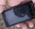
Proof, though dificult to read due to the reflecions on the screen.

Silly grin.
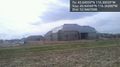
Home under construction near the hashpoint.
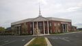
The coordinates were located in a field just behind this church.


Achievements
Eldin earned the Land geohash achievement
|
Eldin earned the Bicycle geohash achievement
|
Eldin earned the Consecutive geohash achievement
|