Difference between revisions of "2013-04-28 52 4"
imported>Palmpje |
(→Achievements) |
||
| (16 intermediate revisions by 4 users not shown) | |||
| Line 15: | Line 15: | ||
}} | }} | ||
| − | + | ||
__NOTOC__ | __NOTOC__ | ||
== Location == | == Location == | ||
| − | + | ||
Langevelderslag, The Netherlands | Langevelderslag, The Netherlands | ||
== Participants == | == Participants == | ||
| − | + | ||
| − | + | * [[User:Murfie|Murfie]] | |
| − | [[User:Murfie|Murfie]] | + | * [[User:Palmpje|Palmpje]] |
== Plans == | == Plans == | ||
| − | + | ||
| − | I'll go there somewhere around noon and hope it's not in a restricted area (dunes). | + | * I'll go there somewhere around noon and hope it's not in a restricted area (dunes). [[User:Murfie|Murfie]] ([[User talk:Murfie|talk]]) |
| − | Heading out there now | + | * Heading out there now (12:45, eta 13:10?) it may even be on the NORA (military radio station terrain), we'll see. [[User:Palmpje|Palmpje]] ([[User talk:Palmpje|talk]]) |
== Expedition == | == Expedition == | ||
| − | + | ||
| + | === Palmpje's story=== | ||
| + | I jumped on my bicycle at 12:45. As Murfie announced that he would be there around noon I did not expect to meet anyone. There were plenty of people on the beach with the sunny weather, though there was a cold wind. Approaching the hash point I saw someone even closer, but before I was near enough he left again. Had a hunch it was Murfie.... but I proceeded to the barb-wire fence that marks the coastal defence zone and registered yet another 76m to go. | ||
| + | |||
| + | I walked back to my bicycle and decided to try the path on the land side of the first dunes and there.... was that guy again. Yes, it was Murfie. We had a short chat but I wanted to be on time for the football (read: soccer) match at 14:00 so had to leave. | ||
| + | |||
| + | (By the way: did I mention the tower?) | ||
| + | |||
| + | In line with this hash, the football was no success either. The home team lost and are still not safe from falling out of the Dutch top amateur league. | ||
| + | |||
| + | ===Murfie's story=== | ||
| + | I left around noon, took a sightseeing route through the flowerbulb | ||
| + | fields and parked about 1.5km from the geohash. | ||
| + | |||
| + | From there, I walked through the 'Hollands Duin' in the direction | ||
| + | of the sea. I entered an area, that when you look it up in google maps, | ||
| + | you will see it is pixelated. | ||
| + | This is because of the presence of an ultra secret military target (http://nl.wikipedia.org/wiki/Radio_Nora). | ||
| + | There are quite some bunkers and there is a large antenna | ||
| + | that more or less exactly fails to please the eye. | ||
| + | |||
| + | When I reached the sea, I washed my shoes in the salty water and | ||
| + | stepped into the sand along the coast in the direction of the geohash. | ||
| + | After 500m, the problem I feared became reality. The geohash was located | ||
| + | in the middle of the dunes and they are fenced. It was about 90m | ||
| + | behind the fence, so at first sight it was unreachable. | ||
| + | |||
| + | However, I knew there was a road on the other side of the dune that | ||
| + | might gave better access to the spot. So I walked another km | ||
| + | to get to the Langevelderslag boulevard. I greeted a motorcycle | ||
| + | gang, found a submarine escape pod (?) and walked the path on the | ||
| + | other side of the dune. | ||
| + | When I was at the level of the geohash, I saw to my disappointment | ||
| + | that I would definately give up on this one. | ||
| + | It was still around 170m and it was all fenced. | ||
| + | |||
| + | For a moment I was considering creeping through the spiky wires, and then I was | ||
| + | surprised by palmpje showing up! We had a quick chat and decided this | ||
| + | geohash is unreachable. | ||
== Tracklog == | == Tracklog == | ||
| Line 38: | Line 76: | ||
== Photos == | == Photos == | ||
| − | + | * Murfie's pictures | |
| − | |||
| − | |||
<gallery perrow="5"> | <gallery perrow="5"> | ||
| + | |||
| + | Image:2013-04-28 52 4 lvs 0700.jpg|One of the many fields with flower bulbs | ||
| + | Image:2013-04-28 52 4 lvs 0701.jpg|They are also for sale | ||
| + | Image:2013-04-28 52 4 lvs 0704.jpg|Map of the area | ||
| + | Image:2013-04-28 52 4 lvs 0705.jpg|To the beach! | ||
| + | Image:2013-04-28 52 4 lvs 0706.jpg|Road leading up to the beach | ||
| + | Image:2013-04-28 52 4 lvs 0707.jpg|Do not disturb | ||
| + | Image:2013-04-28 52 4 lvs 0708.jpg|Radio antenna, blurred in google maps style :) | ||
| + | Image:2013-04-28 52 4 lvs 0711.jpg|North sea (which hosts 50% of all geohashes in this graticule) | ||
| + | Image:2013-04-28 52 4 lvs 0712.jpg|The geohash is right in front of me here | ||
| + | Image:2013-04-28 52 4 lvs 0714.jpg|Motor gang | ||
| + | Image:2013-04-28 52 4 lvs 0716.jpg|Beach car | ||
| + | Image:2013-04-28 52 4 lvs 0718.jpg|Submarine escape pod??? What is this? | ||
| + | Image:2013-04-28 52 4 lvs 0719.jpg|Geohash as viewed from the other side of the dune | ||
| + | Image:2013-04-28 52 4 lvs 0720.jpg|Mercedes oldtimer car trip. | ||
| + | Image:2013-04-28 52 4 lvs 0723.jpg|Tourists taking pictures of tourists | ||
| + | |||
| + | </gallery> | ||
| + | |||
| + | * Palmpje's pictures | ||
| + | <gallery perrow="5"> | ||
| + | Image:2013_04_28_52_4_Distance.JPG|Distance from home | ||
| + | Image:2013_04_28_52_4_NoGo1.JPG|Sorry, no go area 1 | ||
| + | Image:2013_04_28_52_4_Rijnland.JPG|Shield from the water board | ||
| + | Image:2013_04_28_52_4_Noordzee.JPG|Sure, this will flood us! | ||
| + | Image:2013_04_28_52_4_TopSecret.JPG|I'd rather see a bunch of wind energy mills here | ||
| + | Image:2013_04_28_52_4_Nora.JPG|Military terrain | ||
| + | Image:2013_04_28_52_4_NoGo2.JPG|Not even close | ||
| + | Image:2013_04_28_52_4_Art461.JPG|Again, no access | ||
</gallery> | </gallery> | ||
== Achievements == | == Achievements == | ||
{{#vardefine:ribbonwidth|800px}} | {{#vardefine:ribbonwidth|800px}} | ||
| − | + | {{No trespassing |latitude=52 |longitude=4 |date=2013-04-28 |name= [[User:Palmpje|Palmpje]] and [[User:Murfie|Murfie]] | image= 2013_04_28_52_4_Rijnland.JPG | distance=76 meter }} | |
| − | + | {{Two to the N achievement | count = 2 | latitude = 52 | longitude = 4 | date = 2013-04-28 | name = Palmpje }} | |
| − | |||
| − | |||
| − | |||
| − | |||
| − | |||
| − | |||
| − | |||
| − | |||
| − | |||
| − | |||
[[Category:Expeditions]] | [[Category:Expeditions]] | ||
| − | |||
[[Category:Expeditions with photos]] | [[Category:Expeditions with photos]] | ||
| − | |||
| − | |||
| − | |||
| − | |||
| − | |||
| − | |||
| − | |||
| − | |||
| − | |||
[[Category:Coordinates not reached]] | [[Category:Coordinates not reached]] | ||
| − | |||
| − | |||
| − | |||
| − | |||
| − | |||
[[Category:Not reached - No public access]] | [[Category:Not reached - No public access]] | ||
| − | + | {{location|NL|ZH}} | |
| − | |||
| − | |||
| − | |||
| − | |||
| − | |||
| − | |||
| − | |||
Latest revision as of 13:37, 5 March 2021
| Sun 28 Apr 2013 in 52,4: 52.2958254, 4.4715725 geohashing.info google osm bing/os kml crox |
Location
Langevelderslag, The Netherlands
Participants
Plans
- I'll go there somewhere around noon and hope it's not in a restricted area (dunes). Murfie (talk)
- Heading out there now (12:45, eta 13:10?) it may even be on the NORA (military radio station terrain), we'll see. Palmpje (talk)
Expedition
Palmpje's story
I jumped on my bicycle at 12:45. As Murfie announced that he would be there around noon I did not expect to meet anyone. There were plenty of people on the beach with the sunny weather, though there was a cold wind. Approaching the hash point I saw someone even closer, but before I was near enough he left again. Had a hunch it was Murfie.... but I proceeded to the barb-wire fence that marks the coastal defence zone and registered yet another 76m to go.
I walked back to my bicycle and decided to try the path on the land side of the first dunes and there.... was that guy again. Yes, it was Murfie. We had a short chat but I wanted to be on time for the football (read: soccer) match at 14:00 so had to leave.
(By the way: did I mention the tower?)
In line with this hash, the football was no success either. The home team lost and are still not safe from falling out of the Dutch top amateur league.
Murfie's story
I left around noon, took a sightseeing route through the flowerbulb fields and parked about 1.5km from the geohash.
From there, I walked through the 'Hollands Duin' in the direction of the sea. I entered an area, that when you look it up in google maps, you will see it is pixelated. This is because of the presence of an ultra secret military target (http://nl.wikipedia.org/wiki/Radio_Nora). There are quite some bunkers and there is a large antenna that more or less exactly fails to please the eye.
When I reached the sea, I washed my shoes in the salty water and stepped into the sand along the coast in the direction of the geohash. After 500m, the problem I feared became reality. The geohash was located in the middle of the dunes and they are fenced. It was about 90m behind the fence, so at first sight it was unreachable.
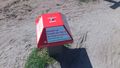
However, I knew there was a road on the other side of the dune that might gave better access to the spot. So I walked another km to get to the Langevelderslag boulevard. I greeted a motorcycle gang, found a submarine escape pod (?) and walked the path on the other side of the dune. When I was at the level of the geohash, I saw to my disappointment that I would definately give up on this one. It was still around 170m and it was all fenced.
For a moment I was considering creeping through the spiky wires, and then I was surprised by palmpje showing up! We had a quick chat and decided this geohash is unreachable.
Tracklog
Photos
- Murfie's pictures
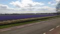
One of the many fields with flower bulbs
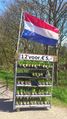
They are also for sale
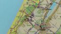
Map of the area
To the beach!
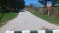
Road leading up to the beach
Do not disturb
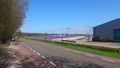
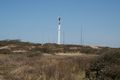
Radio antenna, blurred in google maps style :)
North sea (which hosts 50% of all geohashes in this graticule)
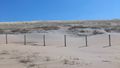
The geohash is right in front of me here
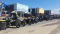
Motor gang
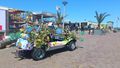
Beach car
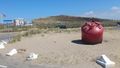
Submarine escape pod??? What is this?
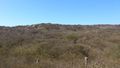
Geohash as viewed from the other side of the dune
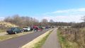
Mercedes oldtimer car trip.
Tourists taking pictures of tourists


- Palmpje's pictures
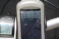
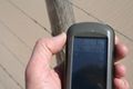
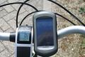
Distance from home
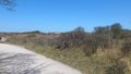
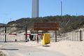
Sorry, no go area 1
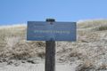
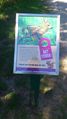
Shield from the water board
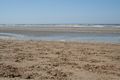
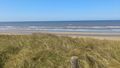
Sure, this will flood us!
I'd rather see a bunch of wind energy mills here
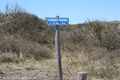
Military terrain
Not even close
Again, no access


Achievements
Palmpje and Murfie earned the No trespassing consolation prize
|
