Difference between revisions of "2013-05-04 -35 138"
From Geohashing
imported>Gertrude (Created page with "{{subst:Expedition |lat = latitude of graticule |lon = longitude of graticule |date = date of expedition, in YYYY-MM-DD format }}") |
m (More specific location) |
||
| (6 intermediate revisions by 3 users not shown) | |||
| Line 1: | Line 1: | ||
| − | |||
| − | |||
| − | |||
| − | |||
| − | |||
| − | |||
| − | |||
| − | |||
| − | |||
| − | |||
{{meetup graticule | {{meetup graticule | ||
| − | | lat= | + | | lat=-35 |
| − | | lon= | + | | lon=138 |
| − | | date= | + | | date=2013-05-04 |
}} | }} | ||
| − | |||
| − | |||
__NOTOC__ | __NOTOC__ | ||
== Location == | == Location == | ||
| − | + | S 35°04.987 E 138°31.416 - At the edge of someone's property (but still in council land!) in Sheidow Park. | |
== Participants == | == Participants == | ||
| − | + | * [[User:Gertrude|Gertrude~]] | |
| − | |||
== Plans == | == Plans == | ||
| − | + | Forgot to check today's Geohash earlier in the day, and only remembered at 7pm, so when identified to be accessible, was in a rush. Drove. | |
== Expedition == | == Expedition == | ||
| − | + | First Geohash by me, and was successful! (I didn't even get lost.) Went and took a picture. I hope the residents of the street were looking at me funny. | |
| − | |||
| − | |||
| − | |||
== Photos == | == Photos == | ||
| − | < | + | <gallery perrow="2"> |
| − | Image: | + | Image:2013-05-04_me.JPG | The Force was with me! |
| − | -- | + | Image:2013-05-04_-35_138_proof.jpg | PROOF! |
| − | |||
</gallery> | </gallery> | ||
== Achievements == | == Achievements == | ||
{{#vardefine:ribbonwidth|800px}} | {{#vardefine:ribbonwidth|800px}} | ||
| − | + | {{land geohash | |
| − | + | | latitude = -35 | |
| − | + | | longitude = 138 | |
| − | + | | date = 2013-05-04 | |
| − | + | | name = [[User:Gertrude|Gertrude~]] | |
| − | [[ | + | | image = 2013-05-04_me.JPG |
| − | + | }} | |
| − | |||
| − | |||
| − | |||
| − | |||
| − | |||
[[Category:Expeditions]] | [[Category:Expeditions]] | ||
| − | |||
[[Category:Expeditions with photos]] | [[Category:Expeditions with photos]] | ||
| − | |||
| − | |||
| − | |||
| − | |||
| − | |||
[[Category:Coordinates reached]] | [[Category:Coordinates reached]] | ||
| − | + | {{location|AU|SA|MA}} | |
| − | |||
| − | |||
| − | |||
| − | |||
| − | |||
| − | |||
| − | |||
| − | |||
| − | |||
| − | |||
| − | |||
| − | |||
| − | |||
| − | |||
| − | |||
| − | |||
| − | |||
Latest revision as of 12:36, 1 August 2020
| Sat 4 May 2013 in -35,138: -35.0831226, 138.5235966 geohashing.info google osm bing/os kml crox |
Location
S 35°04.987 E 138°31.416 - At the edge of someone's property (but still in council land!) in Sheidow Park.
Participants
Plans
Forgot to check today's Geohash earlier in the day, and only remembered at 7pm, so when identified to be accessible, was in a rush. Drove.
Expedition
First Geohash by me, and was successful! (I didn't even get lost.) Went and took a picture. I hope the residents of the street were looking at me funny.
Photos
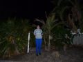
The Force was with me!
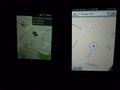
PROOF!


Achievements
Gertrude~ earned the Land geohash achievement
|