Difference between revisions of "2013-05-05 46 11"
imported>Werther (Created page with "{{subst:Expedition |lat = 46 |lon = 11 |date = 2013-05-05 }}") |
m (Location correction) |
||
| (5 intermediate revisions by 2 users not shown) | |||
| Line 18: | Line 18: | ||
__NOTOC__ | __NOTOC__ | ||
== Location == | == Location == | ||
| − | + | In a field on the side of highway SS47 in Pergine. From Street View, it looks perfectly reachable/not private property. | |
== Participants == | == Participants == | ||
| − | + | [[User:Werther|Werther]] | |
| − | |||
== Plans == | == Plans == | ||
| − | + | Yesterday's expedition was fairly challenging and required big amounts of time, but today's hash just looks perfect for a chilled Sunday afternoon expedition. | |
| + | |||
| + | Depending on when I feel like leaving, I will travel by coach or by train- the Valsugana railway which runs between Trento and Venezia is state-owned, but covered by the provincial bus pass until the Veneto boundary. | ||
| + | I'll get to Pergine, and from there it's a 800 m walk to the hashpoint. | ||
== Expedition == | == Expedition == | ||
| − | + | I left home at around 16.15 pm. The weather was beautiful in the morning, but was turning dark- it was just like those quiet moments in movies before the epic final battle- you could sense it was going to rain, but it wasn't starting. | |
| − | + | The bus was a bit late, so I dropped off halfway instead of going all the way to the station, just to make sure I could get the intercity bus to Pergine. It was a quiet trip, and once I got to my destination everything went just as smoothly. I reached the hashpoint, which was even nicer than it looked like on Google Maps- a patch of land on the side of a big highway, just besides a gas station, with nicely cut grass and some lonely trees which clearly weren't autoctone, but were planted by someone. There were no "No trespassing signs", or no kind of fences, so I figured it was some sort of park near the rest area for people to get off the car and stretch their legs a bit. Once I got photo proof and stuff, it started to rain. Since I was ahead on my schedule, I took a detour and reached the train station- mostly because I was in need of a bathroom. The rain got heavier, so the station proved to be a good shelter. Not one but two buses to Trento arrived- I got on a fresh new Irisbus Arway which still smelled like new cars. | |
| − | + | ||
| + | I got to Trento pretty much on time, and I even met a friend while waiting for the bus. The only unpleasant part of the expedition was probably the ride home, as two drunk old men got on and kept shouting in a language I had never even heard. They smelled so bad I literally had trouble breathing- I had to move towards the other side of the bus. | ||
== Photos == | == Photos == | ||
| − | < | + | <gallery> |
| − | Image: | + | Image:20130505 Pergine 001.jpg| Firefighters action in Trento waiting for the coach to Pergine |
| − | + | Image:20130505 Pergine 002.jpg| The Valsugana railway from a level crossing | |
| − | + | Image:20130505 Pergine 003.jpg| Approaching the hashpoint | |
| + | Image:20130505 Pergine 009.jpg| Coordinates reached! | ||
| + | Image:20130505 Pergine 004.jpg| Creepy grin | ||
| + | Image:20130505 Pergine 005.jpg| The location of the hashpoint | ||
| + | Image:20130505 Pergine 006.jpg| Pergine railway station from a bridge | ||
| + | Image:20130505 Pergine 007.jpg| The Pergine castle from a distance | ||
| + | Image:20130505 Pergine 008.jpg| Pergine's platform, serving both the bus station (left) and the rail station (right) | ||
</gallery> | </gallery> | ||
| − | |||
| − | |||
| − | |||
| − | |||
| − | |||
| − | |||
| − | |||
| − | |||
| − | |||
| − | |||
| − | |||
| − | |||
| − | |||
| − | |||
| − | |||
[[Category:Expeditions]] | [[Category:Expeditions]] | ||
| − | |||
| − | |||
| − | |||
| − | |||
| − | |||
| − | |||
| − | |||
[[Category:Coordinates reached]] | [[Category:Coordinates reached]] | ||
| − | + | {{location|IT|TT}} | |
| − | |||
| − | |||
| − | |||
| − | |||
| − | |||
| − | |||
| − | |||
| − | |||
| − | |||
| − | |||
| − | |||
| − | |||
| − | |||
| − | |||
| − | |||
| − | |||
| − | |||
Latest revision as of 15:09, 28 July 2021
| Sun 5 May 2013 in 46,11: 46.0586859, 11.2308397 geohashing.info google osm bing/os kml crox |
Location
In a field on the side of highway SS47 in Pergine. From Street View, it looks perfectly reachable/not private property.
Participants
Plans
Yesterday's expedition was fairly challenging and required big amounts of time, but today's hash just looks perfect for a chilled Sunday afternoon expedition.
Depending on when I feel like leaving, I will travel by coach or by train- the Valsugana railway which runs between Trento and Venezia is state-owned, but covered by the provincial bus pass until the Veneto boundary. I'll get to Pergine, and from there it's a 800 m walk to the hashpoint.
Expedition
I left home at around 16.15 pm. The weather was beautiful in the morning, but was turning dark- it was just like those quiet moments in movies before the epic final battle- you could sense it was going to rain, but it wasn't starting.
The bus was a bit late, so I dropped off halfway instead of going all the way to the station, just to make sure I could get the intercity bus to Pergine. It was a quiet trip, and once I got to my destination everything went just as smoothly. I reached the hashpoint, which was even nicer than it looked like on Google Maps- a patch of land on the side of a big highway, just besides a gas station, with nicely cut grass and some lonely trees which clearly weren't autoctone, but were planted by someone. There were no "No trespassing signs", or no kind of fences, so I figured it was some sort of park near the rest area for people to get off the car and stretch their legs a bit. Once I got photo proof and stuff, it started to rain. Since I was ahead on my schedule, I took a detour and reached the train station- mostly because I was in need of a bathroom. The rain got heavier, so the station proved to be a good shelter. Not one but two buses to Trento arrived- I got on a fresh new Irisbus Arway which still smelled like new cars.
I got to Trento pretty much on time, and I even met a friend while waiting for the bus. The only unpleasant part of the expedition was probably the ride home, as two drunk old men got on and kept shouting in a language I had never even heard. They smelled so bad I literally had trouble breathing- I had to move towards the other side of the bus.
Photos
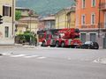
Firefighters action in Trento waiting for the coach to Pergine
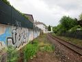
The Valsugana railway from a level crossing
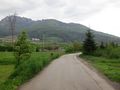
Approaching the hashpoint
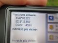
Coordinates reached!
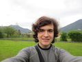
Creepy grin
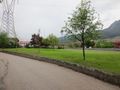
The location of the hashpoint
Pergine railway station from a bridge
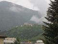
The Pergine castle from a distance
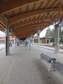
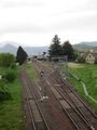
Pergine's platform, serving both the bus station (left) and the rail station (right)


