Difference between revisions of "2013-05-06 33 -116"
From Geohashing
imported>LucasBrown |
imported>FippeBot m (Location) |
||
| (2 intermediate revisions by 2 users not shown) | |||
| Line 3: | Line 3: | ||
__NOTOC__ | __NOTOC__ | ||
== Location == | == Location == | ||
| − | About 40 meters due east of the intersection of Tangle Foot Trail with CA SR78 | + | About 40 meters due east of the intersection of Tangle Foot Trail with CA SR78, in the vicinity of the Pine Hill Egg Ranch in Ramona, CA |
== Participants == | == Participants == | ||
| Line 14: | Line 14: | ||
</gallery> | </gallery> | ||
| − | |||
[[Category:Expeditions]] | [[Category:Expeditions]] | ||
[[Category:Expeditions with photos]] | [[Category:Expeditions with photos]] | ||
[[Category:Expedition without GPS]] | [[Category:Expedition without GPS]] | ||
[[Category:Coordinates reached]] | [[Category:Coordinates reached]] | ||
| + | {{location|US|CA|SD}} | ||
Latest revision as of 02:12, 14 August 2019
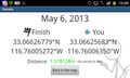
| Mon 6 May 2013 in 33,-116: 33.0662678, -116.7600527 geohashing.info google osm bing/os kml crox |
Location
About 40 meters due east of the intersection of Tangle Foot Trail with CA SR78, in the vicinity of the Pine Hill Egg Ranch in Ramona, CA
Participants
Photos
Geohash Droid details page at the hashpoint
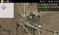
Map at the hashpoint

