Difference between revisions of "2013-05-13 45 11"
imported>Werther |
m (Location correction) |
||
| (3 intermediate revisions by 2 users not shown) | |||
| Line 39: | Line 39: | ||
Just like in my expedition to Albaredo, I had to run to get the bus to Rovereto, but I eventually made it in time. The bus arrived to Calliano on time, and that was the only change I feared I could miss. So most of the timetable stress was gone once I spotted bus no.6 approaching the stop. | Just like in my expedition to Albaredo, I had to run to get the bus to Rovereto, but I eventually made it in time. The bus arrived to Calliano on time, and that was the only change I feared I could miss. So most of the timetable stress was gone once I spotted bus no.6 approaching the stop. | ||
| + | |||
| + | <gallery> | ||
| + | Image:20130513 Calliano 001.jpg|The coach leaving Calliano | ||
| + | Image:20130513 Calliano 002.jpg|Calliano | ||
| + | </gallery> | ||
The trip between Calliano and Nomi was probably the most remarkable part of the day. The small country road going through endless wineyards and eventually crossing the Adige river was a very beautiful landscape. I think I had never taken that road before in my life, so it was a very pleasant discovery. The fact that the bus was almost empty (there only was an old lady apart from me on board) kind of added some magic to the atmosphere. We arrived in Nomi, the northern terminus of the line, where the bus stops for 10 minutes. I took advantage of that small break to get off the bus and eat the packed lunch I had prepared in the morning (two very plain ham sandwiches and a can of iced tea- enough to keep me going until the afternoon). We left on time once again and got to Pomarolo. | The trip between Calliano and Nomi was probably the most remarkable part of the day. The small country road going through endless wineyards and eventually crossing the Adige river was a very beautiful landscape. I think I had never taken that road before in my life, so it was a very pleasant discovery. The fact that the bus was almost empty (there only was an old lady apart from me on board) kind of added some magic to the atmosphere. We arrived in Nomi, the northern terminus of the line, where the bus stops for 10 minutes. I took advantage of that small break to get off the bus and eat the packed lunch I had prepared in the morning (two very plain ham sandwiches and a can of iced tea- enough to keep me going until the afternoon). We left on time once again and got to Pomarolo. | ||
| + | |||
| + | <gallery> | ||
| + | Image:20130513 Calliano-Nomi 003.jpg|Wineyards from the bus window between Calliano and Nomi | ||
| + | Image:20130513 Calliano-Nomi 004.jpg|The Adige river from the bus window | ||
| + | Image:20130513 Nomi 005.jpg|Waiting for the bus to leave in Nomi | ||
| + | Image:20130513 Nomi 006.jpg|Nomi | ||
| + | Image:20130513 Nomi 007.jpg|A white Mother Mary statue on the edge of a cliff over the village, which is a pretty creepy sight if you ask me | ||
| + | Image:20130513 Nomi-Pomarolo 008.jpg|The small village of Chiusole, caught between the A22 highway and the mountains | ||
| + | </gallery> | ||
I was supposed to get on bus no.1 from there, but I eventually learned that the portion of the line between Pomarolo and my destination, Savigliano, was operated by a private company. Since the line is still part of the Trentino Trasporti network, I could use my bus pass without having to pay for a separate ticket. Still, I prefer to ride on public buses rather than private ones, for a number of reasons. So that was a bit of a disappointment, even though the driver was a really nice guy. I got on the small Mercedes shuttle bus and waited for the bus coming from Rovereto. A good number of middle school and high school students got on, so it kind of felt like a school bus rather than a regular ride. Still, there was a very cute looking redhead sitting in the row behind me, so the trip was definitely pleasant. | I was supposed to get on bus no.1 from there, but I eventually learned that the portion of the line between Pomarolo and my destination, Savigliano, was operated by a private company. Since the line is still part of the Trentino Trasporti network, I could use my bus pass without having to pay for a separate ticket. Still, I prefer to ride on public buses rather than private ones, for a number of reasons. So that was a bit of a disappointment, even though the driver was a really nice guy. I got on the small Mercedes shuttle bus and waited for the bus coming from Rovereto. A good number of middle school and high school students got on, so it kind of felt like a school bus rather than a regular ride. Still, there was a very cute looking redhead sitting in the row behind me, so the trip was definitely pleasant. | ||
| + | |||
| + | <gallery> | ||
| + | Image:20130513 Pomarolo 009.jpg|Pomarolo's church, in front of which I had to wait for the bus to Savignano. | ||
| + | Image:20130513 Pomarolo 010.jpg|The panorama from the bus stop | ||
| + | </gallery> | ||
Once in Savignano, the real deal began. The hashpoint was located in a plateau above the small village, called Servis, which could be reached through an approximately-2-km long uphill road. I started walking and tried to keep a good pace, as I knew I didn't have lots of time because I was, once again, subject to timetables. However, a combination of lack of exercise and a pain in my right leg following a dodgeball accident last Saturday made it quite a challenge. I was breathless when I arrived in Servis. From there, it was all downhill to the hashpoint, though sadly not metaphorically. Once I got to the road next to the hashpoint, I noticed it was flooded by a drain. I sighed, knowing I was near to my goal, and walked down the road, but then another issue ensued- my GPS just didn't want to work properly- it kept giving me wrong coordinates. I was moving north and it moved south then back north again. I found myself completely lost, as I wasn't able to recognize the area from the Google Maps aerial view. When I noticed I was getting late for the bus back to Pomarolo, I had no choice but leave. The downhill trip was- needless to say- a lot less tiresome as the trip uphill. I went back to Savignano's place, when I suddenly felt the urge to check the notes about today's hash I had jotted down on my notepad. | Once in Savignano, the real deal began. The hashpoint was located in a plateau above the small village, called Servis, which could be reached through an approximately-2-km long uphill road. I started walking and tried to keep a good pace, as I knew I didn't have lots of time because I was, once again, subject to timetables. However, a combination of lack of exercise and a pain in my right leg following a dodgeball accident last Saturday made it quite a challenge. I was breathless when I arrived in Servis. From there, it was all downhill to the hashpoint, though sadly not metaphorically. Once I got to the road next to the hashpoint, I noticed it was flooded by a drain. I sighed, knowing I was near to my goal, and walked down the road, but then another issue ensued- my GPS just didn't want to work properly- it kept giving me wrong coordinates. I was moving north and it moved south then back north again. I found myself completely lost, as I wasn't able to recognize the area from the Google Maps aerial view. When I noticed I was getting late for the bus back to Pomarolo, I had no choice but leave. The downhill trip was- needless to say- a lot less tiresome as the trip uphill. I went back to Savignano's place, when I suddenly felt the urge to check the notes about today's hash I had jotted down on my notepad. | ||
| + | |||
| + | <gallery> | ||
| + | Image:20130513 Servis 011.jpg|Walking uphill towards Servis | ||
| + | Image:20130513 Servis 012.jpg|Never in my life have I been happier to see a roadsign | ||
| + | Image:20130513 Servis 013.jpg|The flooded road | ||
| + | Image:20130513 Servis 014.jpg|That's as far as I got- I then realized it was time to go back. | ||
| + | Image:20130513 Servis 015.jpg|The beautiful meadows in Servis | ||
| + | Image:20130513 Savignano 016.jpg|Stunning panorama going back towards Sevignano- now this is another wallpaper picture! | ||
| + | Image:20130513 Savignano 017.jpg|Science bits: it's considerably more comfortable to walk downhill | ||
| + | Image:20130513 Savignano 018.jpg|Savignano's small square | ||
| + | </gallery> | ||
That's when it turns out I'd have to wait 45 minutes in Pomarolo for the bus back to Nomi. I hadn't noticed anything when writing it down yesterday. I was pretty impressed by my capacity of having my head totally in the clouds. I didn't feel like waiting almost an hour, so once on the bus I asked the driver whether that run ended in Pomarolo or kept going somewhere else. He answered it was a through service to Villa Lagarina, from where I could have taken bus no.3 to Rovereto. So I decided I could just take a detour to Rovereto and take bus no.5 from there- that's what I did. After all, Rovereto is one of my favourite landscapes in Trentino, so I was glad to get a little grasp of it. Also, that made for a new bus line for my collection! | That's when it turns out I'd have to wait 45 minutes in Pomarolo for the bus back to Nomi. I hadn't noticed anything when writing it down yesterday. I was pretty impressed by my capacity of having my head totally in the clouds. I didn't feel like waiting almost an hour, so once on the bus I asked the driver whether that run ended in Pomarolo or kept going somewhere else. He answered it was a through service to Villa Lagarina, from where I could have taken bus no.3 to Rovereto. So I decided I could just take a detour to Rovereto and take bus no.5 from there- that's what I did. After all, Rovereto is one of my favourite landscapes in Trentino, so I was glad to get a little grasp of it. Also, that made for a new bus line for my collection! | ||
| + | |||
| + | <gallery> | ||
| + | Image:20130513 Villa Lagarina 019.jpg|The shuttle bus leaving Villa Lagarina | ||
| + | Image:20130513 Rovereto 020.jpg|Corso Rosmini, also bus no.3 leaving | ||
| + | </gallery> | ||
The bus in Rovereto was on time, but on the road we got a remarkable delay, something around 10 minutes. The coach in Nomi would've already left if the interchange with the bus wasn't guaranteed. The ride home was fine- for most of the trip, I was the only passenger of the bus. | The bus in Rovereto was on time, but on the road we got a remarkable delay, something around 10 minutes. The coach in Nomi would've already left if the interchange with the bus wasn't guaranteed. The ride home was fine- for most of the trip, I was the only passenger of the bus. | ||
| − | + | <gallery> | |
| − | + | Image:20130513 Nomi 021.jpg|Yay for empty buses! | |
| + | </gallery> | ||
== Achievements == | == Achievements == | ||
| − | |||
| − | |||
| + | {{Blinded by Science | latitude = 45 | longitude = 11 | date = 2013-05-13 | reason = GPS not working properly | name = Werther }} | ||
| − | |||
| − | |||
| − | |||
| − | |||
| − | |||
| − | |||
| − | |||
| − | |||
| − | |||
| − | |||
[[Category:Expeditions]] | [[Category:Expeditions]] | ||
| − | |||
[[Category:Expeditions with photos]] | [[Category:Expeditions with photos]] | ||
| − | |||
| − | |||
| − | |||
| − | |||
| − | |||
| − | |||
| − | |||
| − | |||
| − | |||
[[Category:Coordinates not reached]] | [[Category:Coordinates not reached]] | ||
| − | |||
| − | |||
| − | |||
| − | |||
| − | |||
| − | |||
| − | |||
| − | |||
[[Category:Not reached - Technology]] | [[Category:Not reached - Technology]] | ||
| − | + | {{location|IT|TT}} | |
| − | |||
| − | |||
| − | |||
| − | |||
Latest revision as of 15:10, 28 July 2021
| Mon 13 May 2013 in 45,11: 45.9391568, 11.0677230 geohashing.info google osm bing/os kml crox |
Location
In a field in the Servis area, east of Savignano, Trento.
Participants
Plans
I had thoroughly planned this yesterday, as it looked like a great occasion for an after-school hash.
As you probably know by now, I'm kind of a public transport enthusiast, so this was a great occasion to add some new bus lines to my "taken while geohashing list"... as the plans included:
- Taking a Rovereto-bound coach right after school (the same I took on a previous trip to Albaredo to Calliano;
- From Calliano, taking Rovereto bus no.6 to Nomi (10 minutes stop), and subsequently to Pomarolo;
- From Pomarolo, taking Rovereto bus no.1 to Savignano, from where I'd get to the hashpoint;
- From Savignano, taking Rovereto bus no.1 back to Pomarolo;
- From Pomarolo, taking Rovereto bus no.5 back to Nomi;
- From Nomi, taking a coach back to Trento, which would follow a different path than the Trento-Calliano bus and would also pass through my hometown.
Expedition
It's been a while since I had to report a defeat, although it must be noted that this has been one of the bestest expeditions ever nevertheless. It was a stunningly beautiful day, blessed with clear skies after weeks of bad weather, so no matter the outcome, it has been a great expedition.
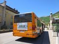
Just like in my expedition to Albaredo, I had to run to get the bus to Rovereto, but I eventually made it in time. The bus arrived to Calliano on time, and that was the only change I feared I could miss. So most of the timetable stress was gone once I spotted bus no.6 approaching the stop.
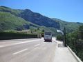
The coach leaving Calliano
Calliano


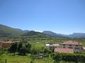
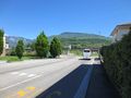
The trip between Calliano and Nomi was probably the most remarkable part of the day. The small country road going through endless wineyards and eventually crossing the Adige river was a very beautiful landscape. I think I had never taken that road before in my life, so it was a very pleasant discovery. The fact that the bus was almost empty (there only was an old lady apart from me on board) kind of added some magic to the atmosphere. We arrived in Nomi, the northern terminus of the line, where the bus stops for 10 minutes. I took advantage of that small break to get off the bus and eat the packed lunch I had prepared in the morning (two very plain ham sandwiches and a can of iced tea- enough to keep me going until the afternoon). We left on time once again and got to Pomarolo.
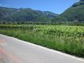
Wineyards from the bus window between Calliano and Nomi
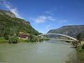
The Adige river from the bus window
Waiting for the bus to leave in Nomi
Nomi
A white Mother Mary statue on the edge of a cliff over the village, which is a pretty creepy sight if you ask me
The small village of Chiusole, caught between the A22 highway and the mountains


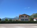
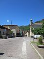
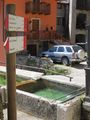
I was supposed to get on bus no.1 from there, but I eventually learned that the portion of the line between Pomarolo and my destination, Savigliano, was operated by a private company. Since the line is still part of the Trentino Trasporti network, I could use my bus pass without having to pay for a separate ticket. Still, I prefer to ride on public buses rather than private ones, for a number of reasons. So that was a bit of a disappointment, even though the driver was a really nice guy. I got on the small Mercedes shuttle bus and waited for the bus coming from Rovereto. A good number of middle school and high school students got on, so it kind of felt like a school bus rather than a regular ride. Still, there was a very cute looking redhead sitting in the row behind me, so the trip was definitely pleasant.
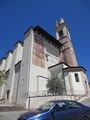
Pomarolo's church, in front of which I had to wait for the bus to Savignano.
The panorama from the bus stop


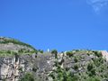
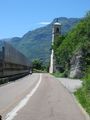
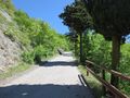
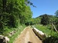
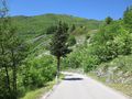
Once in Savignano, the real deal began. The hashpoint was located in a plateau above the small village, called Servis, which could be reached through an approximately-2-km long uphill road. I started walking and tried to keep a good pace, as I knew I didn't have lots of time because I was, once again, subject to timetables. However, a combination of lack of exercise and a pain in my right leg following a dodgeball accident last Saturday made it quite a challenge. I was breathless when I arrived in Servis. From there, it was all downhill to the hashpoint, though sadly not metaphorically. Once I got to the road next to the hashpoint, I noticed it was flooded by a drain. I sighed, knowing I was near to my goal, and walked down the road, but then another issue ensued- my GPS just didn't want to work properly- it kept giving me wrong coordinates. I was moving north and it moved south then back north again. I found myself completely lost, as I wasn't able to recognize the area from the Google Maps aerial view. When I noticed I was getting late for the bus back to Pomarolo, I had no choice but leave. The downhill trip was- needless to say- a lot less tiresome as the trip uphill. I went back to Savignano's place, when I suddenly felt the urge to check the notes about today's hash I had jotted down on my notepad.
Walking uphill towards Servis
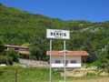
Never in my life have I been happier to see a roadsign
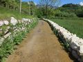
The flooded road
That's as far as I got- I then realized it was time to go back.
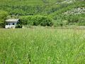
The beautiful meadows in Servis
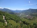
Stunning panorama going back towards Sevignano- now this is another wallpaper picture!
Science bits: it's considerably more comfortable to walk downhill
Savignano's small square


That's when it turns out I'd have to wait 45 minutes in Pomarolo for the bus back to Nomi. I hadn't noticed anything when writing it down yesterday. I was pretty impressed by my capacity of having my head totally in the clouds. I didn't feel like waiting almost an hour, so once on the bus I asked the driver whether that run ended in Pomarolo or kept going somewhere else. He answered it was a through service to Villa Lagarina, from where I could have taken bus no.3 to Rovereto. So I decided I could just take a detour to Rovereto and take bus no.5 from there- that's what I did. After all, Rovereto is one of my favourite landscapes in Trentino, so I was glad to get a little grasp of it. Also, that made for a new bus line for my collection!
The shuttle bus leaving Villa Lagarina
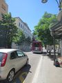
Corso Rosmini, also bus no.3 leaving


The bus in Rovereto was on time, but on the road we got a remarkable delay, something around 10 minutes. The coach in Nomi would've already left if the interchange with the bus wasn't guaranteed. The ride home was fine- for most of the trip, I was the only passenger of the bus.
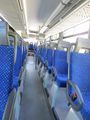
Yay for empty buses!

Achievements
Werther earned the Blinded by Science Consolation Prize
|