Difference between revisions of "2013-05-18 52 8"
imported>Oliver (Created page with "{{subst:Expedition |lat = 52 |lon = 8 |date = 2013-05-19 }}") |
imported>FippeBot m (Location) |
||
| (7 intermediate revisions by one other user not shown) | |||
| Line 1: | Line 1: | ||
| + | [[Image:{{{image|Geohash-2013-05-18-grat-52-8-twistringen-5s.jpg}}}|thumb|left]] | ||
| − | |||
| − | |||
| − | |||
| − | |||
| − | |||
| − | |||
| − | |||
| − | |||
| − | |||
{{meetup graticule | {{meetup graticule | ||
| lat=52 | | lat=52 | ||
| lon=8 | | lon=8 | ||
| − | | date=2013-05- | + | | date=2013-05-18 |
}} | }} | ||
| Line 18: | Line 10: | ||
__NOTOC__ | __NOTOC__ | ||
== Location == | == Location == | ||
| − | + | In a lake near Twistringen. | |
== Participants == | == Participants == | ||
| − | + | [[User:Oliver|Oliver]] | |
| − | |||
== Plans == | == Plans == | ||
| − | + | Todays nearest geohash was again located on the water; so, to make good for my previous geohash which failed due to water, I decided to tackle this one better prepared (with towel and swimming trunks). Foolish me... | |
| + | |||
| + | The geohash was around 30km from home in a direction I rarely explore, so it was time for a nice cycling trip. | ||
== Expedition == | == Expedition == | ||
| − | + | Going there and back again completely by bike seemed a bit too strenuous, so I took the bike on the train to Twistringen and cycled from there to the lake. Only it wasn't a normal lake but an abandoned clay pit. And the signs on the barbed wire fence were pretty impressive too (No Trespassing! Danger to Life!). So much for my great plan. | |
| + | |||
| + | Disappointed, I began exploring the area. This being yet another holiday (Pentecost weekend), the rural area was swarming with locals hauling away small birch trees for the celebration. Apparently nobody quite cared for the signs, and enjoyed some beer on the lake shore - but should I really ignore the Danger signs and go swimming? | ||
| + | |||
| + | But just exploring the area was fun as well - the nearby brick factory had been in operation until 1990, and the municipality had now set up some information tablets about the factory. Also, I found a small wooded area with a beautiful brook running through, and took some pictures. So the trip hadn't been completely in vain; and yet it was painful to again be so close to the goal and yet unable to reach it. Getting ready for the trip home, I decided to make another tour round the lake - and found a gate open that had been closed before! Also, clearly there were people on the other side of the lake. It was now or never. | ||
| + | |||
| + | At the end of the way some cars were parked, and heavily swaying birches nearby suggested that people were still in need of celebration materiel. I left the bike there and found a path down to the water - where an impressive array of fishing rods was arranged, overseen by a small tent. And also to behold: a boat! Plucking up all remaining courage, I hailed at the tent. Two fishermen emerged, a bit startled by my appearance but friendly nonetheless. I explained that the gate had been open, and asked about the boat. Yes, it was theirs, they confirmed. | ||
| − | + | This was it - the moment of truth, where I stood by a lake in the middle of nowhere and would have to explain to two fishermen that I would like to travel onto the lake, to a specific spot somewhere over there. Unable to think of a better story, I told them exactly that; also added that I needed to shoot some pictures at that spot (thereby handwaving at the presumed location of the geohash) and that it was for some game on the Internet. They gave me a look both amused and sceptic - and then one of them said "well why not", got up, fetched two life jackets and went to the boat. | |
| − | + | ||
| + | I sat down in the boat, he rowed me over to where I assumed the geohash to be located, and I took some photos of the GPS reading, the lake and the boat as proof. On the way, we talked a bit, and he was somewhat surprised that some Internet game would send people to "this clay pit here"; which I explained with the coordinates being assigned randomly. | ||
| + | He then mentioned that bathing in the clay pit was indeed dangerous (with several people having drowned already - good thing I hadn't tried swimming), especially due to its depth and the very cold water which would occasionally well up from below and lead to cramps. When I told him how grateful I was about their helpfulness, he just commented that "they are game for any kind of stupid idea". I couldn't have summed up geohashing in a better way. | ||
== Photos == | == Photos == | ||
| − | |||
| − | |||
| − | |||
<gallery perrow="5"> | <gallery perrow="5"> | ||
| + | Image:Geohash-2013-05-18-grat-52-8-twistringen-1s.jpg | Part of the old brick factory | ||
| + | Image:Geohash-2013-05-18-grat-52-8-twistringen-2s.jpg | This brook itself made the trip worthwhile | ||
| + | Image:Geohash-2013-05-18-grat-52-8-twistringen-3s.jpg | Coordinate are pretty close... | ||
| + | Image:Geohash-2013-05-18-grat-52-8-twistringen-4s.jpg | ... the spot must be somewhere around here | ||
| + | Image:Geohash-2013-05-18-grat-52-8-twistringen-5s.jpg | Looking back at an unexpected success | ||
</gallery> | </gallery> | ||
| Line 44: | Line 47: | ||
<!-- Add any achievement ribbons you earned below, or remove this section --> | <!-- Add any achievement ribbons you earned below, or remove this section --> | ||
| + | {{water geohash | ||
| + | | latitude = 52 | ||
| + | | longitude = 8 | ||
| + | | date = 2013-05-18 | ||
| + | | name = Oliver | ||
| + | | image = Geohash-2013-05-18-grat-52-8-twistringen-4s.jpg | ||
| + | | vehicle = boat | ||
| + | }} | ||
| − | + | {{Public transport geohash | |
| − | + | | latitude = 52 | |
| − | + | | longitude = 8 | |
| + | | date = 2013-05-18 | ||
| + | | name = Oliver | ||
| + | }} | ||
| − | + | {{consecutive geohash | |
| − | + | | count = 3 | |
| − | + | | latitude = 52 | |
| − | + | | longitude = 8 | |
| + | | date = 2013-05-18 | ||
| + | | name = Oliver | ||
| + | }} | ||
| − | |||
[[Category:Expeditions]] | [[Category:Expeditions]] | ||
| − | |||
[[Category:Expeditions with photos]] | [[Category:Expeditions with photos]] | ||
| − | |||
| − | |||
| − | |||
| − | |||
| − | |||
[[Category:Coordinates reached]] | [[Category:Coordinates reached]] | ||
| − | + | {{location|DE|NI|DH}} | |
| − | |||
| − | |||
| − | |||
| − | |||
| − | |||
| − | |||
| − | |||
| − | |||
| − | |||
| − | |||
| − | |||
| − | |||
| − | |||
| − | |||
| − | |||
| − | |||
| − | |||
Latest revision as of 02:23, 14 August 2019

| Sat 18 May 2013 in 52,8: 52.8160056, 8.6109384 geohashing.info google osm bing/os kml crox |
Location
In a lake near Twistringen.
Participants
Plans
Todays nearest geohash was again located on the water; so, to make good for my previous geohash which failed due to water, I decided to tackle this one better prepared (with towel and swimming trunks). Foolish me...
The geohash was around 30km from home in a direction I rarely explore, so it was time for a nice cycling trip.
Expedition
Going there and back again completely by bike seemed a bit too strenuous, so I took the bike on the train to Twistringen and cycled from there to the lake. Only it wasn't a normal lake but an abandoned clay pit. And the signs on the barbed wire fence were pretty impressive too (No Trespassing! Danger to Life!). So much for my great plan.
Disappointed, I began exploring the area. This being yet another holiday (Pentecost weekend), the rural area was swarming with locals hauling away small birch trees for the celebration. Apparently nobody quite cared for the signs, and enjoyed some beer on the lake shore - but should I really ignore the Danger signs and go swimming?
But just exploring the area was fun as well - the nearby brick factory had been in operation until 1990, and the municipality had now set up some information tablets about the factory. Also, I found a small wooded area with a beautiful brook running through, and took some pictures. So the trip hadn't been completely in vain; and yet it was painful to again be so close to the goal and yet unable to reach it. Getting ready for the trip home, I decided to make another tour round the lake - and found a gate open that had been closed before! Also, clearly there were people on the other side of the lake. It was now or never.
At the end of the way some cars were parked, and heavily swaying birches nearby suggested that people were still in need of celebration materiel. I left the bike there and found a path down to the water - where an impressive array of fishing rods was arranged, overseen by a small tent. And also to behold: a boat! Plucking up all remaining courage, I hailed at the tent. Two fishermen emerged, a bit startled by my appearance but friendly nonetheless. I explained that the gate had been open, and asked about the boat. Yes, it was theirs, they confirmed.
This was it - the moment of truth, where I stood by a lake in the middle of nowhere and would have to explain to two fishermen that I would like to travel onto the lake, to a specific spot somewhere over there. Unable to think of a better story, I told them exactly that; also added that I needed to shoot some pictures at that spot (thereby handwaving at the presumed location of the geohash) and that it was for some game on the Internet. They gave me a look both amused and sceptic - and then one of them said "well why not", got up, fetched two life jackets and went to the boat.
I sat down in the boat, he rowed me over to where I assumed the geohash to be located, and I took some photos of the GPS reading, the lake and the boat as proof. On the way, we talked a bit, and he was somewhat surprised that some Internet game would send people to "this clay pit here"; which I explained with the coordinates being assigned randomly. He then mentioned that bathing in the clay pit was indeed dangerous (with several people having drowned already - good thing I hadn't tried swimming), especially due to its depth and the very cold water which would occasionally well up from below and lead to cramps. When I told him how grateful I was about their helpfulness, he just commented that "they are game for any kind of stupid idea". I couldn't have summed up geohashing in a better way.
Photos
Part of the old brick factory
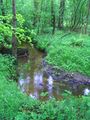
This brook itself made the trip worthwhile
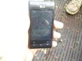
Coordinate are pretty close...
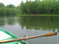
... the spot must be somewhere around here
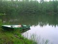
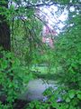
Looking back at an unexpected success


Achievements
Oliver earned the Water geohash achievement
|
Oliver earned the Public transport geohash achievement
|
Oliver earned the Consecutive geohash achievement
|