Difference between revisions of "2013-05-25 47 -122"
imported>OtherJack m (→Participants) |
imported>FippeBot m (Location) |
||
| (22 intermediate revisions by 2 users not shown) | |||
| Line 1: | Line 1: | ||
| + | {{Advert}} | ||
| + | |||
{{meetup graticule | {{meetup graticule | ||
| lat=47 | | lat=47 | ||
| Line 19: | Line 21: | ||
:Zomg I totally didn't realize it was geohashing day! Or Towel day for that matter... now I must make it. Hopefully see you at 5:30... -- [[User:OtherJack|OtherJack]] ([[User talk:OtherJack|talk]]) 15:12, 24 May 2013 (EDT) | :Zomg I totally didn't realize it was geohashing day! Or Towel day for that matter... now I must make it. Hopefully see you at 5:30... -- [[User:OtherJack|OtherJack]] ([[User talk:OtherJack|talk]]) 15:12, 24 May 2013 (EDT) | ||
| − | I | + | == Expedition == |
| − | + | Fitting the geohash in with other activities this day was going to be difficult, but with planning (see Talk page) it could be done! | |
| + | |||
| + | After reading a bit on the [http://www.suquamish.org/Home.aspx|Suquamish website], I decided to include a pilgrimage to the two bronze Sealth statues in Seattle, along with the grave site. Quite appropriate for Memorial Day weekend. | ||
| + | |||
| + | The first two were easily visited. Pictures were snapped with geohash droid giving the coordinates. The first is a statue and fountain, just north of downtown on Denny way at a five-way intersection. A local classic eatery the 5-spot is here, but no time for food on this trip. | ||
| + | |||
| + | The second statue is a bust, just south of downtown in Pioneer Square. Beside it are two panels with text in Suquamish. Not so many people around this early on a Saturday, but later on this "square" would be teeming with tourists and weekend visitors. | ||
| + | |||
| + | Following this I umpired a pair of baseball games at Rainier Beach high school. These were part of a tournament, and both games used nearly the time limit - slow baseball! Wishing my fellow umpires well, I caught up with OtherJack and headed for the ferry, driving past Pioneer Square one more time. Managed to just make it to the docks and on the ferry with moments to spare - my geohashing car was parked at the very back. | ||
| + | |||
| + | Met up with Jack on the passenger deck and we compared notes, achievement plans, tidal ranges and other idle talk. The ferry arrived at Bainbridge Island and we disembarked together, nearly last. Following other ferry goers up the hill and out of town was also quite slow, delaying the actual arrival at the point. | ||
| + | |||
| + | Once the highway was achieved, the way was easy. We turned off into Suquamish and down the hill to the point, the whole area appearing much smaller than estimated from aerial and satellite photos. A very light rain was falling, but not enough for drowned rat. | ||
| + | |||
| + | *On the spot! -- [[User:Thomcat|Thomcat]] ([[User talk:Thomcat|talk]]) [http://www.openstreetmap.org/?lat=47.72898250&lon=-122.55233131&zoom=16&layers=B000FTF @47.7290,-122.5523] 18:31, 25 May 2013 (PDT) | ||
| − | + | Photos were taken (see below), towels and picnics were unveiled, and the sight was generally explored. Very peaceful, nice and quiet, with a lovely view of Ballard across the water. I only wish I had a strong pair of binoculars (or an extreme zoom lens) to pick out features that I recognize. Before the pub, we took a quick trip to the cemetery which was even more quiet and peaceful. Here I completed the Chief Sealth monument trifecta - missing out on a hiking trail, a local high school, and doubtless many other sites. | |
| − | |||
| − | + | Returning from the grave site, we visited the pub and compared ferry schedules. With two equidistant boats to choose from (and the end destination also close to equidistant between the ferry docks) it was mostly a matter of time as to which to choose. A pint and pizza were had, completing the pub geohash and wrapping the day in the winter camp of the Suquamish. | |
| − | |||
== Photos == | == Photos == | ||
| − | |||
| − | |||
| − | |||
<gallery perrow="5"> | <gallery perrow="5"> | ||
| + | |||
| + | Image:2013-05-25_47_-122_10-28-02-280.jpg | At Tilikum Place [http://www.openstreetmap.org/?lat=47.61830591&lon=-122.34778963&zoom=16&layers=B000FTF @47.6183,-122.3478] | ||
| + | Image:2013-05-25_47_-122_10-38-34-559.jpg | At Pioneer Square [http://www.openstreetmap.org/?lat=47.60199644&lon=-122.33377696&zoom=16&layers=B000FTF @47.6020,-122.3338] | ||
| + | Image:2013-05-25_47_-122_17-29-34-695.jpg | On the boat - 5:30 sailing. [http://www.openstreetmap.org/?lat=47.60274752&lon=-122.33959610&zoom=16&layers=B000FTF @47.6027,-122.3396] | ||
| + | Image:2013-05-25_47_-122_17-32-18-706.jpg | Bye bye Seattle [http://www.openstreetmap.org/?lat=47.60297075&lon=-122.34321626&zoom=16&layers=B000FTF @47.6030,-122.3432] | ||
| + | Image:2013-05-25_47_-122_OtherJack_meetup.jpg | ||
| + | |||
| + | Image:2013-05-25_47_-122_18-33-21-693.jpg | OtherJack on the spot. [http://www.openstreetmap.org/?lat=47.72898064&lon=-122.55233212&zoom=16&layers=B000FTF @47.7290,-122.5523] | ||
| + | Image:2013-05-25_47_-122_HouseOfAwakenedCulture.jpg | ||
| + | Image:2013-05-25_47_-122_ViewOfPub.jpg | ||
| + | Image:2013-05-25_47_-122_ViewOfSound.jpg | ||
| + | Image:2013-05-25_47_-122_18-36-10-119.jpg | OtherJack enjoying a picnic with his towel. [http://www.openstreetmap.org/?lat=47.72897727&lon=-122.55231739&zoom=16&layers=B000FTF @47.7290,-122.5523] | ||
| + | |||
| + | Image:2013-05-25_47_-122_VeteransMemorial.jpg | ||
| + | Image:2013-05-25_47_-122_18-52-29-778.jpg | At the gravesite [http://www.openstreetmap.org/?lat=47.73058720&lon=-122.55517747&zoom=16&layers=B000FTF @47.7306,-122.5552] | ||
| + | Image:2013-05-25_47_-122_OtherJack-AgeProbably27.jpg | ||
| + | Image:2013-05-25_47_-122_18-34-27-724.jpg | To the pub! [http://www.openstreetmap.org/?lat=47.72898123&lon=-122.55233024&zoom=16&layers=B000FTF @47.7290,-122.5523] | ||
| + | Image:2013-05-25_47_-122_19-07-02-724.jpg | At the pub; geohash in sight. [http://www.openstreetmap.org/?lat=47.72997373&lon=-122.55115595&zoom=16&layers=B000FTF @47.7300,-122.5512] | ||
| + | |||
| + | Image:2013-05-25_47_-122_20-09-18-535.jpg | Waiting for the ferry to leave for home. [http://www.openstreetmap.org/?lat=47.62216312&lon=-122.50815384&zoom=16&layers=B000FTF @47.6222,-122.5082] | ||
| + | |||
| + | Image:2013-05-25 18.37.55.jpg | OtherJack's proof | ||
| + | Image:2013-05-25 18.38.09.jpg | Thomcat+Towel uploading one of the photos above | ||
| + | Image:2013-05-25 18.38.47.jpg | Pub at right, in background | ||
| + | Image:2013-05-25 18.39.14.jpg | ||
| + | Image:2013-05-25 18.39.35.jpg | Awesome view east from the hash | ||
| + | Image:2013-05-25 18.41.41.jpg | ||
| + | Image:2013-05-25 18.53.52.jpg | ||
| + | Image:2013-05-25 19.00.36.jpg | ||
| + | Image:2013-05-25 19.16.40.jpg | ||
</gallery> | </gallery> | ||
| Line 38: | Line 79: | ||
{{#vardefine:ribbonwidth|800px}} | {{#vardefine:ribbonwidth|800px}} | ||
<!-- Add any achievement ribbons you earned below, or remove this section --> | <!-- Add any achievement ribbons you earned below, or remove this section --> | ||
| + | {{Geohashing Day | latitude = 47 | longitude = -122 | coorddate = 2013-05-25 | year = 2013 | name = Thomcat & OtherJack | mouseover = true | image = 2013-05-25 18.39.35.jpg}} | ||
| + | |||
| + | {{Picnic_geohash | ||
| + | | latitude = 47 | ||
| + | | longitude = -122 | ||
| + | | date = 2013-05-25 | ||
| + | | name = [[User:OtherJack|OtherJack]] | ||
| + | | food = an apple, sitting on a towel and using a paper napkin | ||
| + | | image = 2013-05-25 47 -122 18-36-10-119.jpg | ||
| + | }} | ||
| + | {{pub geohash | ||
| − | [[ | + | | latitude = 47 |
| + | | longitude = -122 | ||
| + | | date = 2013-05-25 | ||
| + | | name = [[User:Thomcat|Thomcat]] and [[User:OtherJack|OtherJack]] | ||
| + | | image = 2013-05-25 47 -122 19-07-02-724.jpg | ||
| + | |||
| + | }} | ||
| + | |||
| + | {{Towel Day | ||
| + | | latitude = 47 | ||
| + | | longitude = -122 | ||
| + | | date = 2013-05-25 | ||
| + | | name = [[User:Thomcat|Thomcat]] and [[User:OtherJack|OtherJack]] | ||
| + | | image = 2013-05-25 18.38.09.jpg | ||
| + | }} | ||
| − | |||
[[Category:Expeditions]] | [[Category:Expeditions]] | ||
| − | |||
[[Category:Expeditions with photos]] | [[Category:Expeditions with photos]] | ||
| − | |||
| − | |||
| − | |||
| − | |||
| − | |||
[[Category:Coordinates reached]] | [[Category:Coordinates reached]] | ||
| − | + | {{location|US|WA|KS}} | |
| − | |||
| − | |||
| − | |||
| − | |||
| − | |||
| − | |||
| − | |||
| − | |||
| − | |||
| − | |||
| − | |||
| − | |||
| − | |||
| − | |||
| − | |||
| − | |||
| − | |||
Latest revision as of 02:32, 14 August 2019
| Have you seen our geohashing marker? We'd love to hear from you! Click here to say "hi" and tell us what you've seen!
Curious about what geohashing is? Read more! |
| Sat 25 May 2013 in Seattle: 47.7289758, -122.5523316 geohashing.info google osm bing/os kml crox |
Location
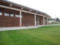
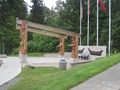
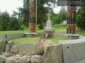
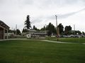
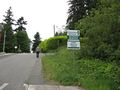
Near the House of Awakened Culture, on Suquamish land, in Kitsap County
Participants
Plans
Meet at the geohash point at roughly 5:30 and celebrate Geohashing Day and Towel Day. Hitchhikers welcome!
- Zomg I totally didn't realize it was geohashing day! Or Towel day for that matter... now I must make it. Hopefully see you at 5:30... -- OtherJack (talk) 15:12, 24 May 2013 (EDT)
Expedition
Fitting the geohash in with other activities this day was going to be difficult, but with planning (see Talk page) it could be done!
After reading a bit on the website, I decided to include a pilgrimage to the two bronze Sealth statues in Seattle, along with the grave site. Quite appropriate for Memorial Day weekend.
The first two were easily visited. Pictures were snapped with geohash droid giving the coordinates. The first is a statue and fountain, just north of downtown on Denny way at a five-way intersection. A local classic eatery the 5-spot is here, but no time for food on this trip.
The second statue is a bust, just south of downtown in Pioneer Square. Beside it are two panels with text in Suquamish. Not so many people around this early on a Saturday, but later on this "square" would be teeming with tourists and weekend visitors.
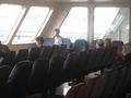
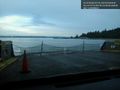
Following this I umpired a pair of baseball games at Rainier Beach high school. These were part of a tournament, and both games used nearly the time limit - slow baseball! Wishing my fellow umpires well, I caught up with OtherJack and headed for the ferry, driving past Pioneer Square one more time. Managed to just make it to the docks and on the ferry with moments to spare - my geohashing car was parked at the very back.
Met up with Jack on the passenger deck and we compared notes, achievement plans, tidal ranges and other idle talk. The ferry arrived at Bainbridge Island and we disembarked together, nearly last. Following other ferry goers up the hill and out of town was also quite slow, delaying the actual arrival at the point.
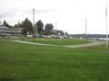
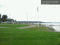
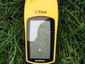
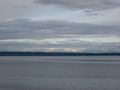
Once the highway was achieved, the way was easy. We turned off into Suquamish and down the hill to the point, the whole area appearing much smaller than estimated from aerial and satellite photos. A very light rain was falling, but not enough for drowned rat.
- On the spot! -- Thomcat (talk) @47.7290,-122.5523 18:31, 25 May 2013 (PDT)
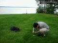
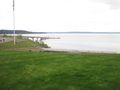
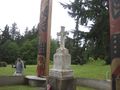
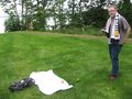
Photos were taken (see below), towels and picnics were unveiled, and the sight was generally explored. Very peaceful, nice and quiet, with a lovely view of Ballard across the water. I only wish I had a strong pair of binoculars (or an extreme zoom lens) to pick out features that I recognize. Before the pub, we took a quick trip to the cemetery which was even more quiet and peaceful. Here I completed the Chief Sealth monument trifecta - missing out on a hiking trail, a local high school, and doubtless many other sites.
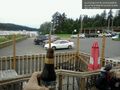
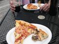
Returning from the grave site, we visited the pub and compared ferry schedules. With two equidistant boats to choose from (and the end destination also close to equidistant between the ferry docks) it was mostly a matter of time as to which to choose. A pint and pizza were had, completing the pub geohash and wrapping the day in the winter camp of the Suquamish.
Photos
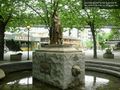
At Tilikum Place @47.6183,-122.3478
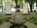
At Pioneer Square @47.6020,-122.3338
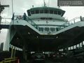
On the boat - 5:30 sailing. @47.6027,-122.3396
Bye bye Seattle @47.6030,-122.3432
OtherJack on the spot. @47.7290,-122.5523
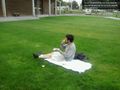
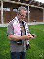
OtherJack enjoying a picnic with his towel. @47.7290,-122.5523
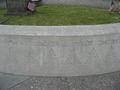
At the gravesite @47.7306,-122.5552
To the pub! @47.7290,-122.5523
At the pub; geohash in sight. @47.7300,-122.5512
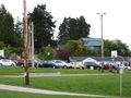
Waiting for the ferry to leave for home. @47.6222,-122.5082
OtherJack's proof
Thomcat+Towel uploading one of the photos above
Pub at right, in background
Awesome view east from the hash


Achievements
Thomcat & OtherJack earned the 2013 Mouse Over Day achievement
|
OtherJack earned the Picnic achievement
|
Thomcat and OtherJack earned the Pub Geohash Achievement
|
Thomcat and OtherJack earned the Towel Day achievement
|