Difference between revisions of "2013-05-30 52 4"
imported>Palmpje |
(→Achievements) |
||
| (8 intermediate revisions by 3 users not shown) | |||
| Line 21: | Line 21: | ||
== Participants == | == Participants == | ||
| − | [[User:Palmpje|Palmpje]] ([[User talk:Palmpje|talk]]) | + | [[User:Palmpje|Palmpje]] ([[User talk:Palmpje|talk]]) has to be near there in the morning so will attempt this one. |
== Plans == | == Plans == | ||
| Line 27: | Line 27: | ||
== Expedition == | == Expedition == | ||
| − | + | Made it, despite a security guard pacing around at the front! See picture of guard.... The path to the hashpoint was at the back of the guard at the left side of the building (which is largely empty). However he was twisting and turning so I did not dare go that way. Next option was to walk all the way around and approach from the other way. And I made it! Had to jump and climb a bit but there I was! The actual point appeared to be 2 meters into the semi-underground parking lot so I jumped in and walked around a bit to make sure I reached the spot. GPS reception was no good so took a picture outside telling me to go yet another 2 meters. Then I made a chalk mark at the approximate location. | |
| + | |||
| + | Now I had to get back again. The same guard was still ambling about but I could sort of sneak out behind his back. Phew! | ||
== Tracklog == | == Tracklog == | ||
<!-- if your GPS device keeps a log, you may post a link here --> | <!-- if your GPS device keeps a log, you may post a link here --> | ||
| + | Sorry, no tracklog. | ||
== Photos == | == Photos == | ||
| − | |||
| − | |||
| − | |||
<gallery perrow="5"> | <gallery perrow="5"> | ||
| + | Image:2013_05_30_52_4_ThatCorner.JPG|OK, now walk around and get there! | ||
| + | Image:2013_05_30_52_4_OfficeGuard.JPG|Well, he looks harmless enough... | ||
| + | Image:2013_05_30_52_4_Proof.JPG|Best reading | ||
| + | Image:2013_05_30_52_4_Marker.JPG|So other people may know the Internet was there | ||
| + | |||
</gallery> | </gallery> | ||
== Achievements == | == Achievements == | ||
| − | {{#vardefine:ribbonwidth| | + | {{#vardefine:ribbonwidth|700px}} |
<!-- Add any achievement ribbons you earned below, or remove this section --> | <!-- Add any achievement ribbons you earned below, or remove this section --> | ||
| + | {{land geohash | latitude = 52 | longitude = 4 | date = 2013-05-30 | name = [[User:Palmpje|Palmpje]] ([[User talk:Palmpje|talk]]) }} | ||
| + | {{Radio Yerevan | achievement = Going Deep Geohash Achievement | detail = only half of his body was underground | ||
| + | | date = 2013-05-30 | latitude = 52 | longitude = 4 | user = [[User:Palmpje|Palmpje]] ([[User talk:Palmpje|talk]]) }} | ||
| + | {{Hash collision | latitude = 52 | longitude = 4 | date = 2013-05-30 | name = Palmpje | id = GC3E2E0 | ||
| + | | distance = 345 meters | honor = just to get this ribbon }} | ||
| + | {{Two to the N achievement | count = 1 | latitude = 52 | longitude = 4 | date = 2013-05-30 | reached = true | name = Palmpje }} | ||
| − | + | <!-- =============== USEFUL CATEGORIES FOLLOW ================ --> | |
| − | <!-- =============== USEFUL CATEGORIES FOLLOW ================ | ||
| − | |||
| − | |||
| − | |||
| − | |||
| − | |||
| − | |||
| − | |||
| − | |||
| − | |||
[[Category:Expeditions]] | [[Category:Expeditions]] | ||
| − | |||
[[Category:Expeditions with photos]] | [[Category:Expeditions with photos]] | ||
| − | |||
| − | |||
| − | |||
| − | |||
| − | |||
[[Category:Coordinates reached]] | [[Category:Coordinates reached]] | ||
| − | + | {{location|NL|ZH}} | |
| − | |||
| − | |||
| − | |||
| − | |||
| − | |||
| − | |||
| − | |||
| − | |||
| − | |||
| − | |||
| − | |||
| − | |||
| − | |||
| − | |||
| − | |||
| − | |||
| − | |||
Latest revision as of 13:43, 5 March 2021
| Thu 30 May 2013 in 52,4: 52.1638727, 4.4625104 geohashing.info google osm bing/os kml crox |
Location
At the back of / in an office in Leiden
Participants
Palmpje (talk) has to be near there in the morning so will attempt this one.
Plans
Park car in the general area and see if I can make it to the hashpoint. I may look silly!
Expedition
Made it, despite a security guard pacing around at the front! See picture of guard.... The path to the hashpoint was at the back of the guard at the left side of the building (which is largely empty). However he was twisting and turning so I did not dare go that way. Next option was to walk all the way around and approach from the other way. And I made it! Had to jump and climb a bit but there I was! The actual point appeared to be 2 meters into the semi-underground parking lot so I jumped in and walked around a bit to make sure I reached the spot. GPS reception was no good so took a picture outside telling me to go yet another 2 meters. Then I made a chalk mark at the approximate location.
Now I had to get back again. The same guard was still ambling about but I could sort of sneak out behind his back. Phew!
Tracklog
Sorry, no tracklog.
Photos
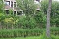
OK, now walk around and get there!
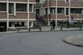
Well, he looks harmless enough...
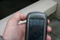
Best reading
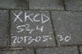
So other people may know the Internet was there


Achievements
Palmpje (talk) earned the Land geohash achievement
|
Is it true that Palmpje (talk) earned the Going Deep Geohash Achievement?
|
Palmpje earned the Hash collision honorable mention
|
