Difference between revisions of "2013-06-08 47 11"
imported>LeslieHapablap (Obligatory stupid grin.) |
imported>FippeBot m (Location) |
||
| (31 intermediate revisions by one other user not shown) | |||
| Line 1: | Line 1: | ||
| − | + | {{Advert}} | |
<!-- If you did not specify these parameters in the template, please substitute appropriate values for IMAGE, LAT, LON, and DATE (YYYY-MM-DD format) | <!-- If you did not specify these parameters in the template, please substitute appropriate values for IMAGE, LAT, LON, and DATE (YYYY-MM-DD format) | ||
| Line 9: | Line 9: | ||
And DON'T FORGET to add your expedition and the best photo you took to the gallery on the Main Page! We'd love to read your report, but that means we first have to discover it! :) | And DON'T FORGET to add your expedition and the best photo you took to the gallery on the Main Page! We'd love to read your report, but that means we first have to discover it! :) | ||
--> | --> | ||
| + | [[Image:2013-06-08 47 11 23-44-34-669.jpg|left|900px]] | ||
{{meetup graticule | {{meetup graticule | ||
| lat=47 | | lat=47 | ||
| Line 14: | Line 15: | ||
| date=2013-06-08 | | date=2013-06-08 | ||
}} | }} | ||
| − | + | {{ClearLeft}} | |
<!-- edit as necessary --> | <!-- edit as necessary --> | ||
__NOTOC__ | __NOTOC__ | ||
| Line 20: | Line 21: | ||
Innsbruck, near Hungerburg-Bahn valley station, conveniently located next to a hiking trail. | Innsbruck, near Hungerburg-Bahn valley station, conveniently located next to a hiking trail. | ||
| + | [[File:2013-06-08 47 11 23-33-44-039.jpg|200px|thumb|left|Near the coordinates.]] | ||
== Participants == | == Participants == | ||
| − | * [[User:LeslieHapablap|LeslieHapablap]] | + | * [[User:LeslieHapablap|LeslieHapablap]], ([[2013-05-10 48 9|previous]]|[[2013-06-14 47 11|next]]) |
* [[User:EleanorAbernathy|EleanorAbernathy]] | * [[User:EleanorAbernathy|EleanorAbernathy]] | ||
| − | * Waltraud the hashkiwi | + | * [[User:LeslieHapablap/Waltraud|Waltraud]] the hashkiwi |
== Plans == | == Plans == | ||
Only 2.8 kilometers away from home as the crow flies, this is almost a couch potato geohash. Perfect occasion to aim for the [[walk geohash]], the [[Circus_Geohash|circus geohash]], maybe the [[Picnic_achievement|picnic achievement]] and who knows what else achievements. As this is our first official Saturday meetup we will try to be there at 4 pm. We hope we will actually meet someone! | Only 2.8 kilometers away from home as the crow flies, this is almost a couch potato geohash. Perfect occasion to aim for the [[walk geohash]], the [[Circus_Geohash|circus geohash]], maybe the [[Picnic_achievement|picnic achievement]] and who knows what else achievements. As this is our first official Saturday meetup we will try to be there at 4 pm. We hope we will actually meet someone! | ||
| − | |||
== Expedition == | == Expedition == | ||
<!-- how it all turned out. your narrative goes here. --> | <!-- how it all turned out. your narrative goes here. --> | ||
| Line 38: | Line 39: | ||
== Tracklog == | == Tracklog == | ||
<!-- if your GPS device keeps a log, you may post a link here --> | <!-- if your GPS device keeps a log, you may post a link here --> | ||
| + | Our [http://goo.gl/maps/LEmLq track], somewhat evidence for the tron achievement. | ||
| + | |||
| + | Dear tron achievement evaluation committee: the apparent loops in this gps track are all due to insufficient gps accuracy in the forest, or the coordinates jumping around wildly while we were standing. Please don't take away our achievement because of this! | ||
== Photos == | == Photos == | ||
| Line 43: | Line 47: | ||
Image:2012-##-## ## ## Alpha.jpg | Witty Comment | Image:2012-##-## ## ## Alpha.jpg | Witty Comment | ||
--> | --> | ||
| − | <gallery perrow=" | + | <gallery widths=300px heights=200px perrow="3"> |
Image:2013-06-08_47_11_23-23-39-801.jpg | A lovely mountain stream... | Image:2013-06-08_47_11_23-23-39-801.jpg | A lovely mountain stream... | ||
| Line 51: | Line 55: | ||
Image:2013-06-08_47_11_23-29-16-157.jpg | The ski-jumping hill at Bergisel, one of the locations of the annual Four Hills Tournament. | Image:2013-06-08_47_11_23-29-16-157.jpg | The ski-jumping hill at Bergisel, one of the locations of the annual Four Hills Tournament. | ||
| − | Image:2013-06-08_47_11_23-33-44-039.jpg | | + | Image:2013-06-08_47_11_23-33-44-039.jpg | Cable car and ramp for mountainbikers near the hashpoint. |
| − | Image:2013-06-08_47_11_23-36-09-538.jpg | Waltraud the hashkiwi happy about reaching the coordinates. | + | Image:2013-06-08_47_11_23-36-09-538.jpg | Waltraud the hashkiwi and EleanorAbernathy happy about reaching the coordinates. |
| + | |||
| + | Image:20130608_162722.jpg | 360° forest. | ||
Image:2013-06-08_47_11_23-37-42-503.jpg | Obligatory proof. | Image:2013-06-08_47_11_23-37-42-503.jpg | Obligatory proof. | ||
Image:2013-06-08_47_11_23-38-13-481.jpg | Obligatory stupid grin. | Image:2013-06-08_47_11_23-38-13-481.jpg | Obligatory stupid grin. | ||
| + | |||
| + | Image:2013-06-08_47_11_23-40-55-038.jpg | Circus achievement [http://www.youtube.com/watch?v=Qsfj1WcCpEE (video)]! I hope the squirrels were impressed. | ||
| + | |||
| + | Image:2013-06-08_47_11_23-41-51-494.jpg | We left a poster. | ||
| + | |||
| + | Image:2013-06-08_47_11_23-44-34-669.jpg | Hungerburg panorama. | ||
| + | |||
| + | Image:2013-06-08_47_11_23-55-48-648.jpg | Cable car arriving at the valley station. | ||
</gallery> | </gallery> | ||
| + | |||
| + | == Other geohashing expeditions on the same day == | ||
| + | |||
| + | {{expedition summaries|2013-06-08}} | ||
== Achievements == | == Achievements == | ||
{{#vardefine:ribbonwidth|800px}} | {{#vardefine:ribbonwidth|800px}} | ||
<!-- Add any achievement ribbons you earned below, or remove this section --> | <!-- Add any achievement ribbons you earned below, or remove this section --> | ||
| + | {{land geohash | ||
| + | |||
| + | | latitude = 47 | ||
| + | | longitude = 11 | ||
| + | | date = 2013-06-08 | ||
| + | | name = [[User:EleanorAbernathy|EleanorAbernathy]] and [[User:LeslieHapablap|LeslieHapablap]] | ||
| + | |||
| + | }} | ||
| + | {{Walk geohash | ||
| + | |||
| + | | latitude = 47 | ||
| + | | longitude = 11 | ||
| + | | date = 2013-06-08 | ||
| + | | name = [[User:EleanorAbernathy|EleanorAbernathy]] and [[User:LeslieHapablap|LeslieHapablap]] | ||
| + | | distance = 10.9 km | ||
| + | }} | ||
| + | {{Circus_geohash | ||
| + | |||
| + | | latitude = 47 | ||
| + | | longitude = 11 | ||
| + | | date = 2013-06-08 | ||
| + | | name = [[User:LeslieHapablap|LeslieHapablap]] | ||
| + | | image = 2013-06-08_47_11_title.png | ||
| + | | performance = juggling | ||
| + | |||
| + | }} | ||
| + | {{Tron | ||
| + | | latitude = 47 | ||
| + | | longitude = 11 | ||
| + | | date = 2013-06-08 | ||
| + | | name = [[User:EleanorAbernathy|EleanorAbernathy]] and [[User:LeslieHapablap|LeslieHapablap]] | ||
| + | | tracklog = http://goo.gl/maps/DgNH7 | ||
| + | | possessive = their | ||
| + | }} | ||
| + | {{Two to the N achievement | ||
| + | |||
| + | | latitude = 47 | ||
| + | | longitude = 11 | ||
| + | | date = 2013-06-08 | ||
| + | | name = [[User:LeslieHapablap|LeslieHapablap]] and [[User:EleanorAbernathy|EleanorAbernathy]] | ||
| + | | count=2 | ||
| + | | reached=True | ||
| + | }} | ||
<!-- =============== USEFUL CATEGORIES FOLLOW ================ | <!-- =============== USEFUL CATEGORIES FOLLOW ================ | ||
| Line 79: | Line 140: | ||
[[Category:Expedition without GPS]] | [[Category:Expedition without GPS]] | ||
--> | --> | ||
| + | [[Category:Expeditions]] | ||
[[Category:Expeditions with photos]] | [[Category:Expeditions with photos]] | ||
| + | [[Category:Expeditions with videos]] | ||
<!-- if you reached your coords: --> | <!-- if you reached your coords: --> | ||
| Line 100: | Line 163: | ||
(Don't forget to delete this final close comment marker) --> | (Don't forget to delete this final close comment marker) --> | ||
| + | {{location|AT|T|I}} | ||
Latest revision as of 02:44, 14 August 2019
| Have you seen our geohashing marker? We'd love to hear from you! Click here to say "hi" and tell us what you've seen!
Curious about what geohashing is? Read more! |

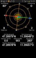
| Sat 8 Jun 2013 in 47,11: 47.2897934, 11.3964875 geohashing.info google osm bing/os kml crox |
Location
Innsbruck, near Hungerburg-Bahn valley station, conveniently located next to a hiking trail.

Participants
- LeslieHapablap, (previous|next)
- EleanorAbernathy
- Waltraud the hashkiwi
Plans
Only 2.8 kilometers away from home as the crow flies, this is almost a couch potato geohash. Perfect occasion to aim for the walk geohash, the circus geohash, maybe the picnic achievement and who knows what else achievements. As this is our first official Saturday meetup we will try to be there at 4 pm. We hope we will actually meet someone!
Expedition
We decided to go for the Tron achievement so we choose a route that first took us up to the Planötzenhof and past the little church "Höttinger Bild" from which we headed towards Gramartboden. From there it was only a short walk to the hashpoint near Hungerburg. We reached the coordinates at about 16:15. The spot was just a few meters away from the Nordpark singletrail and the cable car between Hungerburg and Seegrube. Mountainbikers whizzed past us while we were looking for the exact spot. We marked the place and used the juggling balls we brought to get the circus achievement. Waltraud watched stunned. In order to return to our home without crossing our previous path we headed from Hungerburg down towards the Alpenzoo and then back to Hötting.
All in all this was a really pleasant expedition, the weather was gorgeous an we could reach the hash point without any obstacles like fences or brambles.
Tracklog
Our track, somewhat evidence for the tron achievement.
Dear tron achievement evaluation committee: the apparent loops in this gps track are all due to insufficient gps accuracy in the forest, or the coordinates jumping around wildly while we were standing. Please don't take away our achievement because of this!
Photos
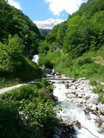
A lovely mountain stream...

... with extreamly clear water.
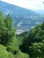
The ski-jumping hill at Bergisel, one of the locations of the annual Four Hills Tournament.
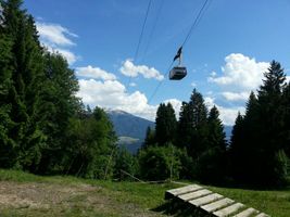
Cable car and ramp for mountainbikers near the hashpoint.
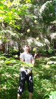
Waltraud the hashkiwi and EleanorAbernathy happy about reaching the coordinates.

360° forest.
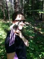
Obligatory proof.
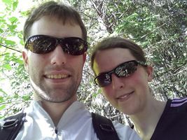
Obligatory stupid grin.
Circus achievement (video)! I hope the squirrels were impressed.
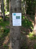
We left a poster.
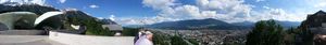
Hungerburg panorama.

Cable car arriving at the valley station.


Other geohashing expeditions on the same day
Expeditions and Plans
| 2013-06-08 | ||
|---|---|---|
| Jacksonville, Florida | Geoff, Erica | In the parking lot of Amanda Webster Design just off Beach Blvd, within hal... |
| State College, Pennsylvania | OfficeLinebacker | In a State Forest in PA |
| Innsbruck, Austria | LeslieHapablap, EleanorAbernathy, Waltraud | Innsbruck, near Hungerburg-Bahn valley station, conveniently located next t... |
| Frankfurt am Main, Germany | QuarterCacher, M, LadyBB, Mampfred, EmmJay | On a field "somewhere in the Taunus". |
| Birmingham, United Kingdom | Nick Holden | Long Itchington, Warwickshire. In a farm field off Marton Road. |
| Amsterdam, Netherlands | Someone went | In the North Sea as usual, just off the beach at Duindamse Slag. Alternate ... |
| Groningen, Netherlands | Elwingelfje | In a meadow, between Noordhorn and Oldehove |
Achievements
EleanorAbernathy and LeslieHapablap earned the Land geohash achievement
|
EleanorAbernathy and LeslieHapablap earned the Walk geohash Achievement
|
LeslieHapablap earned the Circus Geohash Achievement
|
EleanorAbernathy and LeslieHapablap earned the Tron achievement
|
