Difference between revisions of "2013-06-22 47 11"
imported>LeslieHapablap (→Photos) |
imported>FippeBot m (Location) |
||
| (34 intermediate revisions by 3 users not shown) | |||
| Line 1: | Line 1: | ||
| − | + | [[Image:20130622_140734_small.jpg|left|1000px]] | |
| − | |||
| − | |||
| − | |||
| − | |||
| − | |||
| − | |||
| − | |||
| − | |||
| − | |||
| − | [[Image:20130622_140734_small.jpg|1000px]] | ||
{{meetup graticule | {{meetup graticule | ||
| lat=47 | | lat=47 | ||
| Line 15: | Line 5: | ||
| date=2013-06-22 | | date=2013-06-22 | ||
}} | }} | ||
| − | + | {{ClearLeft}} | |
<!-- edit as necessary --> | <!-- edit as necessary --> | ||
__NOTOC__ | __NOTOC__ | ||
| Line 28: | Line 18: | ||
[[File:2013-06-22 47 11 20-19-41-437.jpg|150px|thumb|left|The group.]] | [[File:2013-06-22 47 11 20-19-41-437.jpg|150px|thumb|left|The group.]] | ||
* [[User:EleanorAbernathy|EleanorAbernathy]] | * [[User:EleanorAbernathy|EleanorAbernathy]] | ||
| − | * [[User:LeslieHapablap|LeslieHapablap]] | + | * [[User:LeslieHapablap|LeslieHapablap]], ([[2013-06-14 47 11|previous]]|[[2013-06-29 48 11|next]]) |
| − | * | + | * [[User:1-0|1-0]] |
| − | * Waltraud the Hashkiwi | + | * [[User:LeslieHapablap/Waltraud|Waltraud]] the Hashkiwi |
== Plans == | == Plans == | ||
| Line 41: | Line 31: | ||
This! Was! Awesome! This was stunning and adventurous, relaxing and exhausting, fun and exciting: geohashing. | This! Was! Awesome! This was stunning and adventurous, relaxing and exhausting, fun and exciting: geohashing. | ||
| − | In the morning, Leslie and Eleanor arrived at | + | In the morning, Leslie and Eleanor arrived at [[User:1-0|1-0]]'s place just to find him sleeping in a hammock in the garden, a little hung over from last night's barbecue party. Nothing a coffee couldn't fix, and we were good to go. It was the second drag-along geohash for [[User:1-0|1-0]] and it turned out to be a lot more fun than the last one, which was basically a drive-by on the freeway. We had the perfect weather on our side, a little overcast and not too hot. It was a short trip to Stans were we left our car and started the hike, about 15 km in total and 1000 m difference in altitude. |
| − | |||
[[File:2013-06-22 47 11 20-15-17-986.jpg|300px|thumb|right|St. Georgenberg]] | [[File:2013-06-22 47 11 20-15-17-986.jpg|300px|thumb|right|St. Georgenberg]] | ||
| − | an old monastery built 1708. As soon as we left the slippery stairs of the Wolfsklamm behind us, | + | The first part of our route took us through the picturesque Wolfsklamm, a narrow and steep gorge carved into the mountain by a beautiful stream. This part of the route was totally worth the small admission fee we had to pay. Large parts of the path are built directly to the steep walls with wooden stairs and bridges. On the upper end of the Wolfsklamm lies St. Georgenberg-Fiecht Abbey, |
| + | an old monastery built 1708. As soon as we left the slippery stairs of the Wolfsklamm behind us, [[User:1-0|1-0]] began to juggle while hiking and [http://youtu.be/6erQo5znzVo did not stop for about an hour]. | ||
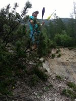
| − | From the Wolfsklamm it was about 6 km to the Stallenalm, mostly through the forest which made for pleasant temperatures. On our way to the hut we passed lazy cows lying in the sun. We tried to explain to them that the internet sent us, but they didn't seem to care about md5-sums and the Dow Jones. Arriving at Stallenalm it started to rain a little bit, but only enough to be a welcome refresher and with the sun still shining. Nevertheless we decided to go directly for the hashpoint and later return to the Stallenalm to have a break. | + | From the Wolfsklamm it was about 6 km to the Stallenalm, mostly through the forest which made for pleasant temperatures. On our way to the hut we passed lazy cows lying in the sun. [[File:2013-06-22 47 11 20-18-39-238.jpg|300px|thumb|left|This one involved a lot of climbing...]] We tried to explain to them that the internet sent us, but they didn't seem to care about md5-sums and the Dow Jones. Arriving at Stallenalm it started to rain a little bit, but only enough to be a welcome refresher and with the sun still shining. Nevertheless we decided to go directly for the hashpoint and later return to the Stallenalm to have a break. |
| − | |||
Finding the hashpoint was a little bit more difficult than expected. On the map it looked like it was only a few meters off a hiking trail, and it really was. But the terrain was very steep and almost inaccessible, with thick bushes, a lot of debris and even a snake guarding the hashpoint. | Finding the hashpoint was a little bit more difficult than expected. On the map it looked like it was only a few meters off a hiking trail, and it really was. But the terrain was very steep and almost inaccessible, with thick bushes, a lot of debris and even a snake guarding the hashpoint. | ||
| − | Until we finally realized we were there it was not clear at all that we would be able to make it. After taking some proof pictures and some more juggling near the hashpoint, we happily returned to the Stallenalm to have lunch. | + | Until we finally realized we were there it was not clear at all that we would be able to make it. You can get an impression how steep it was from the panorama picture above: I was taking this one with [[User:1-0|1-0]] standing just behind me (the feet) and EleanorAbernathy standing just in front of me (the hand). After taking some proof pictures and some more juggling near the hashpoint, we happily returned to the Stallenalm to have lunch. |
| − | |||
| − | |||
| − | |||
| − | |||
| − | |||
| − | |||
| − | |||
| + | For our way back we chose almost exactly the same route we came, only took a small detour around the Wolfsklamm at the end of our hike. On our way we played a few rounds of disc golf: [[File:2013-06-22 47 11 20-24-10-027.jpg|300px|thumb|right|Playing disc golf]] trying to hit a predefined target with a flying disc with as few throws as possible, a fun game! Finally we arrived at the car, and upon our return to Innsbruck we concluded a very successful geohashing expedition with ice cream. | ||
| + | {{-}} | ||
== Photos == | == Photos == | ||
<!-- Insert pictures between the gallery tags using the following format: | <!-- Insert pictures between the gallery tags using the following format: | ||
Image:2012-##-## ## ## Alpha.jpg | Witty Comment | Image:2012-##-## ## ## Alpha.jpg | Witty Comment | ||
--> | --> | ||
| − | <gallery widths=200px perrow="3"> | + | <gallery widths=300px heights=200px perrow="3"> |
Image:2013-06-22_47_11_20-07-18-857.jpg | Paying admission for the entry... | Image:2013-06-22_47_11_20-07-18-857.jpg | Paying admission for the entry... | ||
| Line 82: | Line 66: | ||
Image:2013-06-22_47_11_20-12-02-467.jpg | | Image:2013-06-22_47_11_20-12-02-467.jpg | | ||
| − | Image:2013-06-22_47_11_20-13-09-852.jpg | | + | Image:2013-06-22_47_11_20-13-09-852.jpg | Along the way [[User:1-0|1-0]] started to juggle... |
| − | Image:2013-06-22_47_11_20-14-28-985.jpg | | + | Image:2013-06-22_47_11_20-14-28-985.jpg | ... and couldn't stop anymore ... |
Image:2013-06-22_47_11_20-14-55-647.jpg | | Image:2013-06-22_47_11_20-14-55-647.jpg | | ||
| Line 90: | Line 74: | ||
Image:2013-06-22_47_11_20-15-17-986.jpg | | Image:2013-06-22_47_11_20-15-17-986.jpg | | ||
| − | Image:2013-06-22_47_11_20-15-38-761.jpg | | + | Image:2013-06-22_47_11_20-15-38-761.jpg | ... still juggling ... |
Image:2013-06-22_47_11_20-16-02-550.jpg | | Image:2013-06-22_47_11_20-16-02-550.jpg | | ||
| − | Image:2013-06-22_47_11_20-16-28-482.jpg | | + | Image:2013-06-22_47_11_20-16-28-482.jpg | "You know, the internet sent us..." |
| − | Image:2013-06-22_47_11_20-16-53-637.jpg | | + | Image:2013-06-22_47_11_20-16-53-637.jpg | Arriving at the Stallenalm. |
Image:2013-06-22_47_11_20-17-34-055.jpg | | Image:2013-06-22_47_11_20-17-34-055.jpg | | ||
| Line 106: | Line 90: | ||
Image:2013-06-22_47_11_20-18-39-238.jpg | | Image:2013-06-22_47_11_20-18-39-238.jpg | | ||
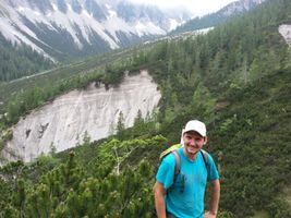
| − | Image:2013-06-22_47_11_20-19-41-437.jpg | Obligatory stupid grin, with Waltraud the Hashkiwi | + | Image:2013-06-22_47_11_20-19-41-437.jpg | Obligatory stupid grin, with [[User:LeslieHapablap/Waltraud|Waltraud]] the Hashkiwi |
| − | Image:2013-06- | + | Image:2013-06-22_47_11_22-11-10-489.jpg | Obligatory proof. |
| − | Image:2013-06-22_47_11_20-20-53-754.jpg | | + | Image:2013-06-22_47_11_20-20-31-158.jpg | Juggling near the hashpoint. |
| + | |||
| + | Image:2013-06-22_47_11_20-20-53-754.jpg | Some more juggling. | ||
Image:2013-06-22_47_11_20-21-12-258.jpg | | Image:2013-06-22_47_11_20-21-12-258.jpg | | ||
| Line 116: | Line 102: | ||
Image:2013-06-22_47_11_20-21-49-797.jpg | | Image:2013-06-22_47_11_20-21-49-797.jpg | | ||
| − | Image:2013-06-22_47_11_20-22-10-226.jpg | | + | Image:2013-06-22_47_11_20-22-10-226.jpg | Looking back to the hashpoint (somewhere in the bushes in the middle of the picture). |
Image:2013-06-22_47_11_20-22-25-342.jpg | | Image:2013-06-22_47_11_20-22-25-342.jpg | | ||
| − | Image:2013-06-22_47_11_20-22-45-106.jpg | | + | Image:2013-06-22_47_11_20-22-45-106.jpg | [[User:1-0|1-0]] being assaulted by a raptor. |
| − | Image:2013-06-22_47_11_20-23-01-102.jpg | | + | Image:2013-06-22_47_11_20-23-01-102.jpg | Stallenalm |
| − | Image:2013-06-22_47_11_20-23-25-431.jpg | | + | Image:2013-06-22_47_11_20-23-25-431.jpg | Stallenalm |
| − | Image:2013-06-22_47_11_20-23-39-395.jpg | | + | Image:2013-06-22_47_11_20-23-39-395.jpg | More raptors! |
Image:2013-06-22_47_11_20-23-53-769.jpg | | Image:2013-06-22_47_11_20-23-53-769.jpg | | ||
| − | Image:2013-06-22_47_11_20-24-10-027.jpg | | + | Image:2013-06-22_47_11_20-24-10-027.jpg | Playing disc golf. |
| − | Image:2013-06-22_47_11_20-24-26-189.jpg | | + | Image:2013-06-22_47_11_20-24-26-189.jpg | Find the flying disc in this picture. |
Image:2013-06-22_47_11_20-25-06-116.jpg | Returninig to Stans. | Image:2013-06-22_47_11_20-25-06-116.jpg | Returninig to Stans. | ||
| + | |||
</gallery> | </gallery> | ||
| + | == Other geohashing expeditions on the same day == | ||
| + | |||
| + | {{expedition summaries|2013-06-22}} | ||
== Achievements == | == Achievements == | ||
{{#vardefine:ribbonwidth|800px}} | {{#vardefine:ribbonwidth|800px}} | ||
<!-- Add any achievement ribbons you earned below, or remove this section --> | <!-- Add any achievement ribbons you earned below, or remove this section --> | ||
| + | {{land geohash | ||
| + | | latitude = 47 | ||
| + | | longitude = 11 | ||
| + | | date = 2013-06-22 | ||
| + | | name = [[User:EleanorAbernathy|EleanorAbernathy]], [[User:LeslieHapablap|LeslieHapablap]] and [[User:1-0|1-0]] | ||
| − | + | }} | |
| − | + | {{Circus_geohash | |
| − | |||
| − | + | | latitude = 47 | |
| − | + | | longitude = 11 | |
| − | + | | date = 2013-06-22 | |
| + | | name = [[User:LeslieHapablap|LeslieHapablap]] and [[User:1-0|1-0]] | ||
| + | | image = 2013-06-22 47 11 20-20-53-754.jpg | ||
| + | | performance = juggling | ||
| + | }} | ||
| − | |||
[[Category:Expeditions]] | [[Category:Expeditions]] | ||
| − | |||
[[Category:Expeditions with photos]] | [[Category:Expeditions with photos]] | ||
[[Category:Expeditions with videos]] | [[Category:Expeditions with videos]] | ||
| − | |||
| − | |||
| − | |||
| − | |||
[[Category:Coordinates reached]] | [[Category:Coordinates reached]] | ||
| − | + | {{location|AT|T|SZ}} | |
| − | |||
| − | |||
| − | |||
| − | |||
| − | |||
| − | |||
| − | |||
| − | |||
| − | |||
| − | |||
| − | |||
| − | |||
| − | |||
| − | |||
| − | |||
| − | |||
| − | |||
Latest revision as of 02:55, 14 August 2019

| Sat 22 Jun 2013 in 47,11: 47.3842603, 11.6385155 geohashing.info google osm bing/os kml crox |
Location
Near Stallenalm, Karwendel.
Participants

- EleanorAbernathy
- LeslieHapablap, (previous|next)
- 1-0
- Waltraud the Hashkiwi
Plans
We are going to hike up the Wolfsklamm from Stans, then to the Stallenalm, from there it is not far anymore to the hashpoint. Probably we well be there around noon, not at 4pm because there is a chance of thunderstorms in the afternoon.
Expedition

This! Was! Awesome! This was stunning and adventurous, relaxing and exhausting, fun and exciting: geohashing.
In the morning, Leslie and Eleanor arrived at 1-0's place just to find him sleeping in a hammock in the garden, a little hung over from last night's barbecue party. Nothing a coffee couldn't fix, and we were good to go. It was the second drag-along geohash for 1-0 and it turned out to be a lot more fun than the last one, which was basically a drive-by on the freeway. We had the perfect weather on our side, a little overcast and not too hot. It was a short trip to Stans were we left our car and started the hike, about 15 km in total and 1000 m difference in altitude.

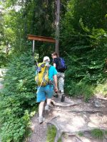
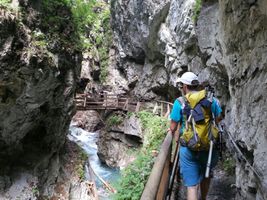
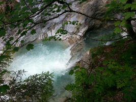
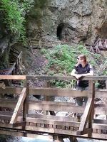
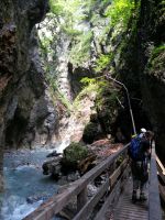
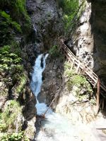
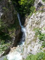
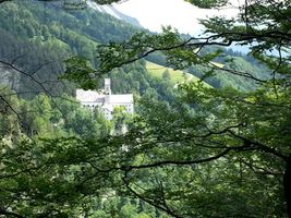
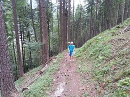
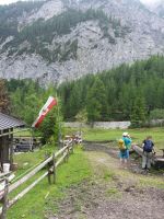
The first part of our route took us through the picturesque Wolfsklamm, a narrow and steep gorge carved into the mountain by a beautiful stream. This part of the route was totally worth the small admission fee we had to pay. Large parts of the path are built directly to the steep walls with wooden stairs and bridges. On the upper end of the Wolfsklamm lies St. Georgenberg-Fiecht Abbey, an old monastery built 1708. As soon as we left the slippery stairs of the Wolfsklamm behind us, 1-0 began to juggle while hiking and did not stop for about an hour.
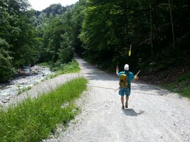
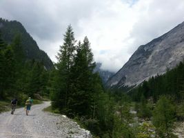
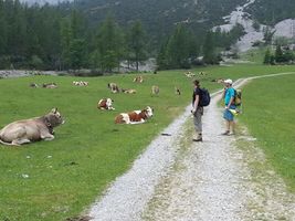
From the Wolfsklamm it was about 6 km to the Stallenalm, mostly through the forest which made for pleasant temperatures. On our way to the hut we passed lazy cows lying in the sun.

We tried to explain to them that the internet sent us, but they didn't seem to care about md5-sums and the Dow Jones. Arriving at Stallenalm it started to rain a little bit, but only enough to be a welcome refresher and with the sun still shining. Nevertheless we decided to go directly for the hashpoint and later return to the Stallenalm to have a break.
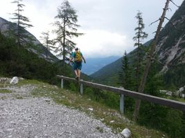
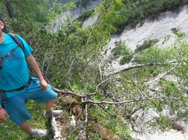
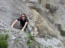
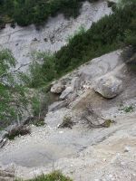
Finding the hashpoint was a little bit more difficult than expected. On the map it looked like it was only a few meters off a hiking trail, and it really was. But the terrain was very steep and almost inaccessible, with thick bushes, a lot of debris and even a snake guarding the hashpoint. Until we finally realized we were there it was not clear at all that we would be able to make it. You can get an impression how steep it was from the panorama picture above: I was taking this one with 1-0 standing just behind me (the feet) and EleanorAbernathy standing just in front of me (the hand). After taking some proof pictures and some more juggling near the hashpoint, we happily returned to the Stallenalm to have lunch.
For our way back we chose almost exactly the same route we came, only took a small detour around the Wolfsklamm at the end of our hike. On our way we played a few rounds of disc golf:

trying to hit a predefined target with a flying disc with as few throws as possible, a fun game! Finally we arrived at the car, and upon our return to Innsbruck we concluded a very successful geohashing expedition with ice cream.
Photos
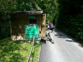
Paying admission for the entry...
... to the Wolfsklamm.
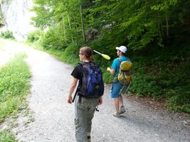
Along the way 1-0 started to juggle...
... and couldn't stop anymore ...
... still juggling ...
"You know, the internet sent us..."
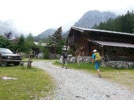
Arriving at the Stallenalm.
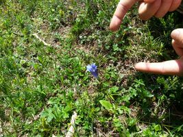
Enzian!
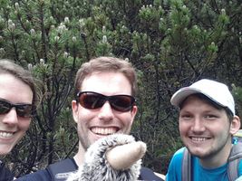
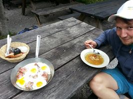
Obligatory stupid grin, with Waltraud the Hashkiwi
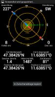
Obligatory proof.
Juggling near the hashpoint.
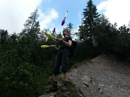
Some more juggling.
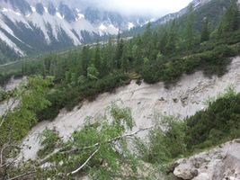
Looking back to the hashpoint (somewhere in the bushes in the middle of the picture).
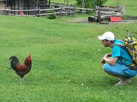
1-0 being assaulted by a raptor.
Stallenalm

Stallenalm
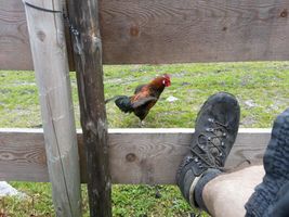
More raptors!
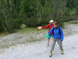
Playing disc golf.
Find the flying disc in this picture.
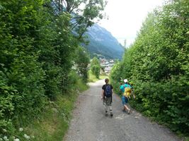
Returninig to Stans.


Other geohashing expeditions on the same day
Expeditions and Plans
| 2013-06-22 | ||
|---|---|---|
| Innsbruck, Austria | EleanorAbernathy, LeslieHapablap, 1-0, Waltraud | Near Stallenalm, Karwendel. |
| Zürich, Switzerland | Chris 47 8, Calamus | Hermikon, just outside Dübendorf. |
| Stuttgart, Germany | Kobras | A soccer field near Schelklingen. |
Achievements
EleanorAbernathy, LeslieHapablap and 1-0 earned the Land geohash achievement
|
LeslieHapablap and 1-0 earned the Circus Geohash Achievement
|