Difference between revisions of "2013-06-25 47 -122"
imported>Thomcat ([live picture] My kingdom for a GPS that doesn't have problems with trees! [http://www.openstreetmap.org/?lat=47.75384673&lon=-122.22505549&zoom=16&layers=B000FTF @47.7538,-122.2251]) |
imported>FippeBot m (Location) |
||
| (2 intermediate revisions by one other user not shown) | |||
| Line 21: | Line 21: | ||
*D minus 10k -- [[User:Thomcat|Thomcat]] ([[User talk:Thomcat|talk]]) [http://www.openstreetmap.org/?lat=47.73933521&lon=-122.35043997&zoom=16&layers=B000FTF @47.7393,-122.3504] 06:35, 25 June 2013 (PDT) | *D minus 10k -- [[User:Thomcat|Thomcat]] ([[User talk:Thomcat|talk]]) [http://www.openstreetmap.org/?lat=47.73933521&lon=-122.35043997&zoom=16&layers=B000FTF @47.7393,-122.3504] 06:35, 25 June 2013 (PDT) | ||
| + | |||
| + | Found the apartment complex easily, quite a bit after 4 though. Pulled in and around and then... the GPS stopped updating. Not sure if it's the Android phone (the app wasn't doing well?) or the trees (quite skimpy, really), but I think it's about time I got a real GPS. | ||
| + | |||
| + | Anyhow, took a few pictures then tried everything short of rebooting the phone. GPS would update, but slowly - I walked the width of 5 cars from the parking strip and the GPS reported I went from 4.5 meters away down to 4.19 which doesn't reflect reality. End result - I was on the spot at some point, and I even was within the GPS accuracy reported (4.2 meters). Uploaded the photos and hit the road for home. | ||
== Photos == | == Photos == | ||
| − | |||
| − | |||
| − | |||
<gallery perrow="5"> | <gallery perrow="5"> | ||
Image:2013-06-25_47_-122_16-43-53-180.jpg | My kingdom for a GPS that doesn't have problems with trees! [http://www.openstreetmap.org/?lat=47.75384673&lon=-122.22505549&zoom=16&layers=B000FTF @47.7538,-122.2251] | Image:2013-06-25_47_-122_16-43-53-180.jpg | My kingdom for a GPS that doesn't have problems with trees! [http://www.openstreetmap.org/?lat=47.75384673&lon=-122.22505549&zoom=16&layers=B000FTF @47.7538,-122.2251] | ||
| + | |||
| + | Image:2013-06-25_47_-122_16-45-55-209.jpg | Hi from Bothell [http://www.openstreetmap.org/?lat=47.75384723&lon=-122.22505454&zoom=16&layers=B000FTF @47.7538,-122.2251] | ||
</gallery> | </gallery> | ||
| − | |||
| − | |||
| − | |||
| − | |||
| − | |||
| − | |||
| − | |||
| − | |||
[[Category:Expeditions]] | [[Category:Expeditions]] | ||
| − | |||
[[Category:Expeditions with photos]] | [[Category:Expeditions with photos]] | ||
| − | |||
| − | |||
| − | |||
| − | |||
| − | |||
[[Category:Coordinates reached]] | [[Category:Coordinates reached]] | ||
| − | + | {{location|US|WA|KN}} | |
| − | |||
| − | |||
| − | |||
| − | |||
| − | |||
| − | |||
| − | |||
| − | |||
| − | |||
| − | |||
| − | |||
| − | |||
| − | |||
| − | |||
| − | |||
| − | |||
| − | |||
Latest revision as of 02:57, 14 August 2019
| Tue 25 Jun 2013 in Seattle: 47.7538188, -122.2250190 geohashing.info google osm bing/os kml crox |
Location
A parking strip in an apartment complex just off Bothell Way
Participants
Plans
Wasn't on the way to work, but it will be on the way home. Stop by
Expedition
Already in the commute, I punched up today's point (at a stop light of course). Geohash Android tells me Bothell, and zooming in I see it's just off Bothell Way, also known as state highway 522. This connector leads down from Highway 2 to Seattle proper, and is my favorite route to work and often to and from Eastern Washington.
- D minus 10k -- Thomcat (talk) @47.7393,-122.3504 06:35, 25 June 2013 (PDT)
Found the apartment complex easily, quite a bit after 4 though. Pulled in and around and then... the GPS stopped updating. Not sure if it's the Android phone (the app wasn't doing well?) or the trees (quite skimpy, really), but I think it's about time I got a real GPS.
Anyhow, took a few pictures then tried everything short of rebooting the phone. GPS would update, but slowly - I walked the width of 5 cars from the parking strip and the GPS reported I went from 4.5 meters away down to 4.19 which doesn't reflect reality. End result - I was on the spot at some point, and I even was within the GPS accuracy reported (4.2 meters). Uploaded the photos and hit the road for home.
Photos
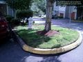
My kingdom for a GPS that doesn't have problems with trees! @47.7538,-122.2251

Hi from Bothell @47.7538,-122.2251

