Difference between revisions of "2013-06-25 62 25"
imported>Tilley |
imported>Tilley |
||
| Line 1: | Line 1: | ||
{{meetup graticule | {{meetup graticule | ||
| − | | lat= | + | | lat=62 |
| − | | lon= | + | | lon=25 |
| − | | date=2013- | + | | date=2013-06-25 |
}} | }} | ||
__NOTOC__ | __NOTOC__ | ||
== Location == | == Location == | ||
| − | In | + | In Kangashäkki, Uurainen. The point lies in forest near lake Pieni Pirttilampi. |
== Participants == | == Participants == | ||
*[[User:Tilley|Tilley]] | *[[User:Tilley|Tilley]] | ||
| + | |||
| + | == Plans == | ||
| + | |||
| + | Today it's my birthday! Almost like a birthday present, a geohashpoint fell splendidly on our way (again) when we we're traveling from my parents-in-law to our home. (The reason why hashpoints so often fall on our way when we make this trip is, that our journey spans four graticules, and we have two route options, which are almost equally long. Thus we can adjust our route according to hashpoints. :) ) | ||
== Expedition == | == Expedition == | ||
| − | + | [[File:2013-06-25_62_25_DSC2932_1500px.jpg|250px|thumb|left|The forest was very dry.]] | |
| − | + | The expedition itself was easy and quick. We parked our car, I put on my hiking shoes and entered the bone-dry forest. The terrain was sandy and forest quite easy to traverse, because there were old forest machine tracks which were free from trees. The point was near a small lake, and I had hoped there would be a view from the hashpoint to the lake. This hope was in vain, the forest was much too dense. I could see only tiny glimpse of the water. (Visible also in the picture.) | |
| − | |||
| − | + | [[File:2013-06-25_62_25_DSC2933_1500px.jpg|400px|thumb|right|A birthday-grin!]] | |
| − | + | As I was trying to set a self-portrait with the timer by placing the camera on a tree stump, I got attacked by angry ants. (not angry birds) The first picture didn't capture my head, but when I tried to adjust the aim, the ants swarmed up my legs (I was wearing shorts) and began to bite. I thus had to abandon the hash-site and didn't get that self-portrait. | |
| − | + | I then went back and we continued our drive. Sorry, my inspiration to write a longer report has dried up in this heat. Today was hot! It was 28 °C in the shade and our car doesn't have air conditioning. Now it's 20:30 and it's still 25 °C outside. Much too warm for me, I don't function well in hot weather. | |
| − | |||
| − | Additional | + | Additional distance driven by car to get to the hashpoint: 1 km. Walking distance: 400 m. |
== Additional photos == | == Additional photos == | ||
<gallery> | <gallery> | ||
| − | Image:2013- | + | Image:2013-06-25_62_25_DSC2935_1500px.jpg | The proof. |
| − | |||
</gallery> | </gallery> | ||
| Line 38: | Line 39: | ||
{{#vardefine:ribbonwidth|800px}} | {{#vardefine:ribbonwidth|800px}} | ||
| − | {{land geohash | latitude = | + | {{Birthday geohash |
| + | | latitude = 62 | ||
| + | | longitude = 25 | ||
| + | | date = 2013-06-25 | ||
| + | | pronoun = his | ||
| + | | number = 33th | ||
| + | | name = [[User:Tilley|Tilley]] | ||
| + | | image = 2013-06-25_62_25_DSC2933_1500px.jpg | ||
| + | }} | ||
| + | |||
| + | {{land geohash | latitude = 62 | longitude = 25 | date = 2013-06-25 | name = Tilley | image = 2013-06-25_62_25_DSC2933_1500px.jpg | ||
}} | }} | ||
Revision as of 18:20, 29 July 2013
| Tue 25 Jun 2013 in 62,25: 62.5101440, 25.6750339 geohashing.info google osm bing/os kml crox |
Location
In Kangashäkki, Uurainen. The point lies in forest near lake Pieni Pirttilampi.
Participants
Plans
Today it's my birthday! Almost like a birthday present, a geohashpoint fell splendidly on our way (again) when we we're traveling from my parents-in-law to our home. (The reason why hashpoints so often fall on our way when we make this trip is, that our journey spans four graticules, and we have two route options, which are almost equally long. Thus we can adjust our route according to hashpoints. :) )
Expedition

The expedition itself was easy and quick. We parked our car, I put on my hiking shoes and entered the bone-dry forest. The terrain was sandy and forest quite easy to traverse, because there were old forest machine tracks which were free from trees. The point was near a small lake, and I had hoped there would be a view from the hashpoint to the lake. This hope was in vain, the forest was much too dense. I could see only tiny glimpse of the water. (Visible also in the picture.)

As I was trying to set a self-portrait with the timer by placing the camera on a tree stump, I got attacked by angry ants. (not angry birds) The first picture didn't capture my head, but when I tried to adjust the aim, the ants swarmed up my legs (I was wearing shorts) and began to bite. I thus had to abandon the hash-site and didn't get that self-portrait.
I then went back and we continued our drive. Sorry, my inspiration to write a longer report has dried up in this heat. Today was hot! It was 28 °C in the shade and our car doesn't have air conditioning. Now it's 20:30 and it's still 25 °C outside. Much too warm for me, I don't function well in hot weather.
Additional distance driven by car to get to the hashpoint: 1 km. Walking distance: 400 m.
Additional photos
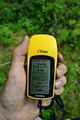
The proof.

Achievements
Tilley earned the Birthday Geohash Achievement
|
Tilley earned the Land geohash achievement
|