Difference between revisions of "2013-07-06 39 -77"
imported>OfficeLinebacker ([http://www.openstreetmap.org/?lat=39.04274900&lon=-77.39504957&zoom=16&layers=B000FTF @39.0427,-77.3950]) |
imported>FippeBot m (Location) |
||
| (13 intermediate revisions by 2 users not shown) | |||
| Line 19: | Line 19: | ||
== Location == | == Location == | ||
<!-- where you've surveyed the hash to be --> | <!-- where you've surveyed the hash to be --> | ||
| + | In the Potomac River near Sterling, VA | ||
== Participants == | == Participants == | ||
<!-- who attended: If you link to your wiki user name in this section, your expedition will be picked up by the various statistics generated for geohashing. You may use three tildes ~ as a shortcut to automatically insert the user signature of the account you are editing with. | <!-- who attended: If you link to your wiki user name in this section, your expedition will be picked up by the various statistics generated for geohashing. You may use three tildes ~ as a shortcut to automatically insert the user signature of the account you are editing with. | ||
--> | --> | ||
| + | * Allison | ||
| + | * [[User:OfficeLinebacker|OfficeLinebacker]] ([[User talk:OfficeLinebacker|talk]]) | ||
== Plans == | == Plans == | ||
<!-- what were the original plans --> | <!-- what were the original plans --> | ||
| + | Try to walk to the spot, then wade/swim into the river to get a water achievement | ||
== Expedition == | == Expedition == | ||
<!-- how it all turned out. your narrative goes here. --> | <!-- how it all turned out. your narrative goes here. --> | ||
| + | This was a pretty epic achievement. It was about 96 degrees the whole time. We chugged water and Powerade to prepare. | ||
| + | |||
| + | I had seen several hashpoints which were anywhere from right at the edge of a river to a few dozen feet into the river and had had in mind for several weeks now to try a water achievement by wading or swimming into a river and this point provided the perfect opportunity. | ||
| + | |||
| + | We parked at a boat slip about 3/4 of a mile away from the spot. It was just an exploratory spot, as there were roads that would take us closer, but I felt this might be a good place to start and scout the path. Well I turned out to be right because there was a path almost directly to the hashpoint, only with one twist. I was limited in my ability to navigate and take pictures because my phone charge wasn't very strong, being only about 20% when we left the car. | ||
| + | |||
| + | We followed the path along the Potomac and about 2/3 of the way there there was a big river that joins the Potomac. The water was very scummy and it was quite wide and deep (maybe about 50 feet wide) so we decided to walk along the river because it looked like there was a lake we could get to, and we could circumambulate the lake and get to the other side. We saw a couple of trees that had fallen and almost bridged the river, but not quite enough to actually create an easily crossable bridge. However on the third tree across the river we saw evidence of humans having crossed it so we went for it. I crossed once without the towel or cell phone just to make sure it could be done. I came back to Allison and retrieved the stuff and we both crossed again. It was not an easy crossing by any stretch but it was fun. | ||
| + | |||
| + | We continued along paths until we got to a small picnic table that was exactly at the point on the shore nearest the hash. There was a floating platform anchored about 70 feet offshore, that had a propane grill bolted to it as well as a potted plant. As I waded out into the water, I stopped to pose for a pic and I felt something weird at my toes. Some fish were nibbling at my toes and lower legs. They mostly focused on my cuticles and a blister so it was like [http://en.wikipedia.org/wiki/Doctor_fish doctor fish]. Anyway I decided to swim out to the platform, which was harder than I thought. Then, what was REALLY harder than I thought was hoisting myself up onto the platform. I tried and failed twice before I was able to grab one of the legs of the BBQ and haul myself up. | ||
| + | |||
| + | Allison declined to join me. There were lots of the same little fish all around the platform. I dangled my feet in the water but at that point, they were not interested. The weather felt so much cooler out on the water with a nice coating of water, than walking there. | ||
| + | |||
| + | I swam back and was greeted by a smiling Allison with a towel. I toweled off and we headed back. We came to the mouth of the river again because Allison was considering wading across, but when I showed her the scummy water she agreed we should cross the tree bridge (she didn't like crossing it the first time because it was pretty sketchy). | ||
| + | |||
| + | The trip back was relatively uneventful and we got back to the car. By then Allison had a massive upside down "T" on her shirt in salt, because she had sweated so much. About halfway back from my swim, I crossed the threshold of most of the wetness of my clothing being from my sweat, rather than from the swim. | ||
| + | |||
| + | A very epic hash, and a new achievement. Very fun! | ||
| + | |||
| + | As far as the water achievement, the exact location of the hash was a little iffy. I stood near where they point seemed to be according to the map, but my GPS was saying we were still about 50 feet away. Seeing as the point was almost directly between where I entered the water and the floating platform, and I swam most of the way to it, I'm giving myself credit for the water geohash achievement. | ||
== Tracklog == | == Tracklog == | ||
| Line 66: | Line 89: | ||
Image:2013-07-06_39_-77_15-36-50-768.jpg | [http://www.openstreetmap.org/?lat=39.04274900&lon=-77.39504957&zoom=16&layers=B000FTF @39.0427,-77.3950] | Image:2013-07-06_39_-77_15-36-50-768.jpg | [http://www.openstreetmap.org/?lat=39.04274900&lon=-77.39504957&zoom=16&layers=B000FTF @39.0427,-77.3950] | ||
| + | |||
| + | Image:2013-07-06_39_-77_15-37-13-833.jpg | [http://www.openstreetmap.org/?lat=39.04073658&lon=-77.39728785&zoom=16&layers=B000FTF @39.0407,-77.3973] | ||
| + | |||
| + | Image:2013-07-06_39_-77_15-37-52-993.jpg | The actual spot | ||
| + | |||
| + | Image:2013-07-06_39_-77_15-38-21-301.jpg | The silly faces | ||
</gallery> | </gallery> | ||
| Line 72: | Line 101: | ||
<!-- Add any achievement ribbons you earned below, or remove this section --> | <!-- Add any achievement ribbons you earned below, or remove this section --> | ||
| + | {{water geohash | ||
| + | | latitude = 39 | ||
| + | | longitude = -77 | ||
| + | | date = 2013-07-06 | ||
| + | | name = OfficeLinebacker | ||
| + | | image = 2013-07-06_39_-77_15-35-58-463.jpg | ||
| + | | vehicle = swimming | ||
| + | }} | ||
| − | |||
| − | |||
| − | |||
| − | |||
| − | |||
| − | |||
| − | |||
| − | |||
| − | |||
| − | |||
[[Category:Expeditions]] | [[Category:Expeditions]] | ||
| − | + | [[Category:Expeditions with photos]] | |
| − | [[Category:Expeditions with photos]] | ||
| − | |||
| − | |||
| − | |||
| − | |||
| − | |||
[[Category:Coordinates reached]] | [[Category:Coordinates reached]] | ||
| − | + | {{location|US|MD|MO}} | |
| − | |||
| − | |||
| − | |||
| − | |||
| − | |||
| − | |||
| − | |||
| − | |||
| − | |||
| − | |||
| − | |||
| − | |||
| − | |||
| − | |||
| − | |||
| − | |||
| − | |||
Latest revision as of 03:03, 14 August 2019
| Sat 6 Jul 2013 in 39,-77: 39.0623966, -77.3639936 geohashing.info google osm bing/os kml crox |
Location
In the Potomac River near Sterling, VA
Participants
- Allison
- OfficeLinebacker (talk)
Plans
Try to walk to the spot, then wade/swim into the river to get a water achievement
Expedition
This was a pretty epic achievement. It was about 96 degrees the whole time. We chugged water and Powerade to prepare.
I had seen several hashpoints which were anywhere from right at the edge of a river to a few dozen feet into the river and had had in mind for several weeks now to try a water achievement by wading or swimming into a river and this point provided the perfect opportunity.
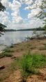
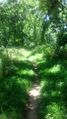
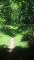
We parked at a boat slip about 3/4 of a mile away from the spot. It was just an exploratory spot, as there were roads that would take us closer, but I felt this might be a good place to start and scout the path. Well I turned out to be right because there was a path almost directly to the hashpoint, only with one twist. I was limited in my ability to navigate and take pictures because my phone charge wasn't very strong, being only about 20% when we left the car.
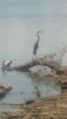
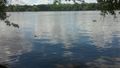
We followed the path along the Potomac and about 2/3 of the way there there was a big river that joins the Potomac. The water was very scummy and it was quite wide and deep (maybe about 50 feet wide) so we decided to walk along the river because it looked like there was a lake we could get to, and we could circumambulate the lake and get to the other side. We saw a couple of trees that had fallen and almost bridged the river, but not quite enough to actually create an easily crossable bridge. However on the third tree across the river we saw evidence of humans having crossed it so we went for it. I crossed once without the towel or cell phone just to make sure it could be done. I came back to Allison and retrieved the stuff and we both crossed again. It was not an easy crossing by any stretch but it was fun.
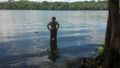
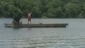
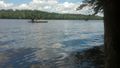
We continued along paths until we got to a small picnic table that was exactly at the point on the shore nearest the hash. There was a floating platform anchored about 70 feet offshore, that had a propane grill bolted to it as well as a potted plant. As I waded out into the water, I stopped to pose for a pic and I felt something weird at my toes. Some fish were nibbling at my toes and lower legs. They mostly focused on my cuticles and a blister so it was like doctor fish. Anyway I decided to swim out to the platform, which was harder than I thought. Then, what was REALLY harder than I thought was hoisting myself up onto the platform. I tried and failed twice before I was able to grab one of the legs of the BBQ and haul myself up.
Allison declined to join me. There were lots of the same little fish all around the platform. I dangled my feet in the water but at that point, they were not interested. The weather felt so much cooler out on the water with a nice coating of water, than walking there.
I swam back and was greeted by a smiling Allison with a towel. I toweled off and we headed back. We came to the mouth of the river again because Allison was considering wading across, but when I showed her the scummy water she agreed we should cross the tree bridge (she didn't like crossing it the first time because it was pretty sketchy).
The trip back was relatively uneventful and we got back to the car. By then Allison had a massive upside down "T" on her shirt in salt, because she had sweated so much. About halfway back from my swim, I crossed the threshold of most of the wetness of my clothing being from my sweat, rather than from the swim.
A very epic hash, and a new achievement. Very fun!
As far as the water achievement, the exact location of the hash was a little iffy. I stood near where they point seemed to be according to the map, but my GPS was saying we were still about 50 feet away. Seeing as the point was almost directly between where I entered the water and the floating platform, and I swam most of the way to it, I'm giving myself credit for the water geohash achievement.
Tracklog
Photos

Close enough @39.0622,-77.3641
The actual spot

The silly faces


Achievements
OfficeLinebacker earned the Water geohash achievement
|