Difference between revisions of "2013-07-07 47 -122"
imported>Thomcat (Steilacoom expedition) |
imported>FippeBot m (Location) |
||
| (5 intermediate revisions by one other user not shown) | |||
| Line 12: | Line 12: | ||
== Participants == | == Participants == | ||
| − | * [[User:Thomcat|Thomcat]] | + | * [[User:Thomcat|Thomcat]] and dog Lucy |
== Plans == | == Plans == | ||
| Line 18: | Line 18: | ||
== Expedition == | == Expedition == | ||
| − | + | My Android (revision Donut, or maybe it's BonBon) is getting a little long in the tooth. When I hopped family and dog into the car, it didn't want to resolve where I was --- so reboot! | |
| − | == | + | The drive to Tacoma went quickly by, and then we headed west through Lakewood. This is a part of Tacoma I haven't driven through before, and some day I'd like to come back and visit Fort Steilacoom. The sky was filled with early morning clouds that would likely burn off by afternoon. |
| − | + | ||
| + | The GPS came up fine the second time, so I snapped a picture of the spot and set out to achieve it. Family and Lucy stopped as the slimed over beach became difficult to navigate, but I continued on. As the train went by northbound, I snapped it as well. | ||
| + | |||
| + | I uploaded these on the move, so to speak, so the GPS coords below reflect where I was walking. Most importantly, I reached the spot, still a few feet above water. The camera at this point stopped working (the camera app showed no picture), so I took some pics with the old-fashioned digital camera and clicked the "post to wiki" button: | ||
| + | |||
| + | :*Android camera stopped, but on the spot! -- [[User:Thomcat|Thomcat]] ([[User talk:Thomcat|talk]]) [http://www.openstreetmap.org/?lat=47.17546162&lon=-122.59638205&zoom=16&layers=B000FTF @47.1755,-122.5964] 11:33, 7 July 2013 (PDT) | ||
| + | |||
| + | As I write this (3:10 pm) this spot is probably under water, heading for a high tide at 7:27 pm that is 14.7 feet above the low mark during my visit. Without family and dog, I might have stuck around to be underwater and claim the water geohash... | ||
| + | |||
| + | Just up the beach from the hashpoint was a good sized crab, scuttling away from me. I snapped his picture and headed back to the family. | ||
| + | |||
| + | A short drive up the bay, across and down brought us right back to the beach and Chambers Creek park, with off-leash beach park. We eyed the golf course (home of the 2015 US Open!) as we drove past. On the beach, we found more crabs, kelp, and the occasional jelly creature. Lucy tried licking one and rolled in the seaweed many times - a furry flopping fish. | ||
| + | |||
| + | The return to Seattle was uneventful. The Geohashing algorithm comes through with a Seattle Adventure once again! | ||
== Photos == | == Photos == | ||
| Line 28: | Line 41: | ||
--> | --> | ||
<gallery perrow="5"> | <gallery perrow="5"> | ||
| − | |||
| − | == | + | Image:2013-07-07_47_-122_11-26-58-755.jpg | Approaching spot [http://www.openstreetmap.org/?lat=47.17600617&lon=-122.59288177&zoom=16&layers=B000FTF @47.1760,-122.5929] |
| − | + | ||
| − | + | Image:2013-07-07_47_-122_11-28-50-647.jpg | Train! [http://www.openstreetmap.org/?lat=47.17545843&lon=-122.59478545&zoom=16&layers=B000FTF @47.1755,-122.5948] | |
| + | |||
| + | Image:2013-07-07_47_-122_Ferry.jpg | To the south, the ferry was leaving | ||
| + | Image:2013-07-07_47_-122_NorthFromPoint.jpg | Looking North from the Hashpoint | ||
| + | Image:2013-07-07_47_-122_Geohasher.jpg | Grinnish | ||
| + | Image:2013-07-07_47_-122_HashCrab.jpg | This crab was scuttling away from the hashpoint. | ||
| + | Image:2013-07-07_47_-122_12-19-48-646.jpg | Off leash dog park nearby. [http://www.openstreetmap.org/?lat=47.20136079&lon=-122.58308396&zoom=16&layers=B000FTF @47.2014,-122.5831] | ||
| − | + | Image:2013-07-07_47_-122_RubItIn.jpg | Lucy loves to wallow in the beach smell. | |
| + | </gallery> | ||
| − | |||
[[Category:Expeditions]] | [[Category:Expeditions]] | ||
| − | |||
[[Category:Expeditions with photos]] | [[Category:Expeditions with photos]] | ||
| − | |||
| − | |||
| − | |||
| − | |||
| − | |||
[[Category:Coordinates reached]] | [[Category:Coordinates reached]] | ||
| − | + | {{location|US|WA|PI}} | |
| − | |||
| − | |||
| − | |||
| − | |||
| − | |||
| − | |||
| − | |||
| − | |||
| − | |||
| − | |||
| − | |||
| − | |||
| − | |||
| − | |||
| − | |||
| − | |||
| − | |||
Latest revision as of 03:04, 14 August 2019
| Sun 7 Jul 2013 in Seattle: 47.1754668, -122.5963789 geohashing.info google osm bing/os kml crox |
Location
On the beach in Steilacoom, just south of Sunnyside Beach park.
Participants
- Thomcat and dog Lucy
Plans
Expedition at low tide, which is 11:53 AM today. Also visit the park and a nearby off-leash dog park.
Expedition
My Android (revision Donut, or maybe it's BonBon) is getting a little long in the tooth. When I hopped family and dog into the car, it didn't want to resolve where I was --- so reboot!
The drive to Tacoma went quickly by, and then we headed west through Lakewood. This is a part of Tacoma I haven't driven through before, and some day I'd like to come back and visit Fort Steilacoom. The sky was filled with early morning clouds that would likely burn off by afternoon.
The GPS came up fine the second time, so I snapped a picture of the spot and set out to achieve it. Family and Lucy stopped as the slimed over beach became difficult to navigate, but I continued on. As the train went by northbound, I snapped it as well.
I uploaded these on the move, so to speak, so the GPS coords below reflect where I was walking. Most importantly, I reached the spot, still a few feet above water. The camera at this point stopped working (the camera app showed no picture), so I took some pics with the old-fashioned digital camera and clicked the "post to wiki" button:
- Android camera stopped, but on the spot! -- Thomcat (talk) @47.1755,-122.5964 11:33, 7 July 2013 (PDT)
As I write this (3:10 pm) this spot is probably under water, heading for a high tide at 7:27 pm that is 14.7 feet above the low mark during my visit. Without family and dog, I might have stuck around to be underwater and claim the water geohash...
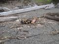
Just up the beach from the hashpoint was a good sized crab, scuttling away from me. I snapped his picture and headed back to the family.
A short drive up the bay, across and down brought us right back to the beach and Chambers Creek park, with off-leash beach park. We eyed the golf course (home of the 2015 US Open!) as we drove past. On the beach, we found more crabs, kelp, and the occasional jelly creature. Lucy tried licking one and rolled in the seaweed many times - a furry flopping fish.
The return to Seattle was uneventful. The Geohashing algorithm comes through with a Seattle Adventure once again!
Photos
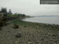
Approaching spot @47.1760,-122.5929
Train! @47.1755,-122.5948
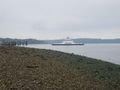
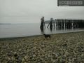
To the south, the ferry was leaving
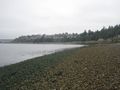
Looking North from the Hashpoint

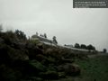
Grinnish
This crab was scuttling away from the hashpoint.
Off leash dog park nearby. @47.2014,-122.5831
Lucy loves to wallow in the beach smell.


