Difference between revisions of "2013-07-14 52 1"
imported>Sourcerer m ([live] Arrived.) |
imported>Sourcerer (→Sourcerer Expedition) |
||
| Line 1: | Line 1: | ||
| − | |||
| − | |||
| − | |||
| − | |||
| − | |||
| − | |||
| − | |||
| − | |||
| − | |||
| − | |||
{{meetup graticule | {{meetup graticule | ||
| − | | lat=52 | + | | lat=52 |
| − | | lon=1 | + | | lon=1 |
| − | | date=2013-07-14 | + | | date=2013-07-14 |
| + | | graticule_name=Norwich | ||
| + | | graticule_link=Norwich, United Kingdom | ||
}} | }} | ||
| − | |||
| − | |||
== Location == | == Location == | ||
| − | + | ||
| + | In a wheat field between Weybread and Fressingfield, Suffolk, UK | ||
== Participants == | == Participants == | ||
| − | |||
| − | |||
| − | + | [[User:Sourcerer|Sourcerer]] | |
| − | |||
== Expedition == | == Expedition == | ||
| − | |||
| + | *Arrived. -- [[User:Sourcerer|Sourcerer]] ([[User talk:Sourcerer|talk]]) [http://www.openstreetmap.org/?lat=52.360475063323975&lon=1.2994176149368286&zoom=16&layers=B000FTF @52.3605,1.2994] 11:00, 14 July 2013 (GMT+01:00) | ||
| + | |||
| + | The hashpoint was 20km from home, so easily reached by car and on foot. There was a parking place less than 1km from the hashpoint. There were overgrown public footpaths to within 10 metres of the destination which was reached by crossing a dry but overgrown ditch. I chose not to walk the last few steps to avoid crop damage but there was no other barrier preventing access. I think this counts as "co-ordinates reached". The wheat crop looked fat and healthy and was beginning to ripen. The overgrown paths were full of grass seeds that stick to socks so I'll have a happy hour ahead picking out the seeds. It's all part of the fun. | ||
| − | |||
== Tracklog == | == Tracklog == | ||
| − | + | ||
| + | My hand-held GPS receiver batteries went flat at the wrong moment but the hashpoint could still be located using my Android phone application. | ||
== Photos == | == Photos == | ||
| − | |||
| − | |||
| − | |||
<gallery perrow="5"> | <gallery perrow="5"> | ||
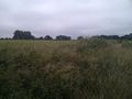
| + | Image:2013-07-14 52 1 Sourcerer 01.jpg | The hashpoint. | ||
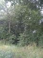
| + | Image:2013-07-14 52 1 Sourcerer 02.jpg | Near the hashpoint. | ||
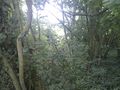
| + | Image:2013-07-14 52 1 Sourcerer 03.jpg | Near the hashpoint. | ||
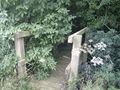
| + | Image:2013-07-14 52 1 Sourcerer 04.jpg | Near the hashpoint. | ||
| + | Image:2013-07-14 52 1 Sourcerer 05.jpg | Barley in the next field. | ||
</gallery> | </gallery> | ||
| − | == | + | == Other geohashing expeditions on the same day == |
| − | |||
| − | |||
| − | |||
| − | |||
| − | |||
| − | |||
| − | |||
| − | + | {{expedition summaries|2013-07-14}} | |
| − | |||
| − | |||
| − | |||
| − | |||
[[Category:Expeditions]] | [[Category:Expeditions]] | ||
| − | |||
[[Category:Expeditions with photos]] | [[Category:Expeditions with photos]] | ||
| − | |||
| − | |||
| − | |||
| − | |||
| − | |||
[[Category:Coordinates reached]] | [[Category:Coordinates reached]] | ||
| − | |||
| − | |||
| − | |||
| − | |||
| − | |||
| − | |||
| − | |||
| − | |||
| − | |||
| − | |||
| − | |||
| − | |||
| − | |||
| − | |||
| − | |||
| − | |||
| − | |||
| − | |||
Revision as of 13:53, 14 July 2013
| Sun 14 Jul 2013 in Norwich: 52.3604403, 1.2995779 geohashing.info google osm bing/os kml crox |
Contents
Location
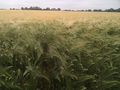
In a wheat field between Weybread and Fressingfield, Suffolk, UK
Participants
Expedition
- Arrived. -- Sourcerer (talk) @52.3605,1.2994 11:00, 14 July 2013 (GMT+01:00)
The hashpoint was 20km from home, so easily reached by car and on foot. There was a parking place less than 1km from the hashpoint. There were overgrown public footpaths to within 10 metres of the destination which was reached by crossing a dry but overgrown ditch. I chose not to walk the last few steps to avoid crop damage but there was no other barrier preventing access. I think this counts as "co-ordinates reached". The wheat crop looked fat and healthy and was beginning to ripen. The overgrown paths were full of grass seeds that stick to socks so I'll have a happy hour ahead picking out the seeds. It's all part of the fun.
Tracklog
My hand-held GPS receiver batteries went flat at the wrong moment but the hashpoint could still be located using my Android phone application.
Photos
The hashpoint.
Near the hashpoint.
Near the hashpoint.
Near the hashpoint.
Barley in the next field.


Other geohashing expeditions on the same day
Expeditions and Plans
| 2013-07-14 | ||
|---|---|---|
| Seattle, Washington | OtherJack | Deep in the undergrowth near I-5 and S. 272nd in Kent |
| Reims, France | Beltxarga | In a field between Ménil-Lépinois and Aussonce. |
| Norwich, United Kingdom | Sourcerer | In a wheat field between Weybread and Fressingfield, Suffolk, UK |