Difference between revisions of "2013-07-15 50 8"
imported>Yakamoz ([live picture] A view to the tennis court) |
m |
||
| (5 intermediate revisions by 4 users not shown) | |||
| Line 5: | Line 5: | ||
}} | }} | ||
| − | + | ||
__NOTOC__ | __NOTOC__ | ||
== Location == | == Location == | ||
| Line 13: | Line 13: | ||
== Participants == | == Participants == | ||
| − | [[User:GeorgDerReisende|GeorgDerReisende]] | + | * [[User:GeorgDerReisende|GeorgDerReisende]] |
| − | + | * [[User:Yakamoz | Yakamoz]] | |
| − | [[User:Yakamoz | Yakamoz]] | ||
== Plans == | == Plans == | ||
| Line 24: | Line 23: | ||
== Expedition (Yakamoz)== | == Expedition (Yakamoz)== | ||
| − | + | ||
I saw yesterday that this geohash could be an easy geohash for me because it was very close to my home, only 700m away. So I certainly didn't want to miss this geohash! I looked at the Google map and knew exactly where the geohash lies because I pass this district every day. | I saw yesterday that this geohash could be an easy geohash for me because it was very close to my home, only 700m away. So I certainly didn't want to miss this geohash! I looked at the Google map and knew exactly where the geohash lies because I pass this district every day. | ||
I biked there before my "skiing gymnastics" in the evening. I went quickly into the forest between a car dealer and a tennis court and reached the coordinates as close as it was possible with the GPS of my smartphone. Then I biked to my training. - Quick, easy and less than spectacular :-) | I biked there before my "skiing gymnastics" in the evening. I went quickly into the forest between a car dealer and a tennis court and reached the coordinates as close as it was possible with the GPS of my smartphone. Then I biked to my training. - Quick, easy and less than spectacular :-) | ||
| − | == | + | == Expedition (GeorgDerReisende) == |
| − | + | ||
| + | After I had successfully arrived at [[2013-07-15 51 7]], I wanted to travel to this place, again by hitchhiking. | ||
| + | |||
| + | But I failed. At first I have taken the bus to Kamen. From the junction ''Kamen'' at the A1 I have gotten | ||
| + | a short lift to the service station ''Lichtendorf''. There I waited from 18:50 to 20:15, but no cars | ||
| + | passed by for the A45, which is going south to Gießen from there. | ||
| + | |||
| + | I had calculated a travel time of | ||
| + | three hours to Gießen, and because I wanted to arrive before sundown, I decided to give up and went | ||
| + | home. | ||
| + | |||
| + | So I added ''Category:Not reached''. | ||
| + | |||
| + | |||
== Photos == | == Photos == | ||
| − | + | ||
| − | |||
| − | |||
<gallery perrow="5"> | <gallery perrow="5"> | ||
Image:2013-07-15_50_8_22-14-35-691.jpg | Distance from my home to the geohash | Image:2013-07-15_50_8_22-14-35-691.jpg | Distance from my home to the geohash | ||
| − | |||
Image:2013-07-15_50_8_22-15-19-319.jpg | Coordinates reached | Image:2013-07-15_50_8_22-15-19-319.jpg | Coordinates reached | ||
| − | |||
Image:2013-07-15_50_8_22-54-57-363.jpg | A view to the tennis court | Image:2013-07-15_50_8_22-54-57-363.jpg | A view to the tennis court | ||
| + | Image:2013-07-15_50_8_22-56-18-006.jpg | Geohash point | ||
</gallery> | </gallery> | ||
== Achievements == | == Achievements == | ||
{{#vardefine:ribbonwidth|800px}} | {{#vardefine:ribbonwidth|800px}} | ||
| − | + | ||
{{Land geohash | {{Land geohash | ||
| latitude = 50 | | latitude = 50 | ||
| Line 61: | Line 70: | ||
| name = Yakamoz | | name = Yakamoz | ||
}} | }} | ||
| + | |||
[[Category:Expeditions]] | [[Category:Expeditions]] | ||
| − | |||
| − | |||
| − | |||
| − | |||
| − | |||
| − | |||
| − | |||
| − | |||
| − | |||
| − | |||
| − | |||
| − | |||
| − | |||
| − | |||
| − | |||
[[Category:Expeditions with photos]] | [[Category:Expeditions with photos]] | ||
| − | |||
| − | |||
| − | |||
| − | |||
| − | |||
[[Category:Coordinates reached]] | [[Category:Coordinates reached]] | ||
| − | + | <!--[[Category:Coordinates not reached]] | |
| − | + | [[Category:Not reached - Time constraints]]--> | |
| − | [[Category:Coordinates not reached]] | + | {{location|DE|HE|GI}} |
| − | |||
| − | |||
| − | [[Category:Not reached - | ||
| − | |||
| − | |||
| − | |||
| − | |||
| − | |||
| − | |||
| − | |||
| − | |||
| − | |||
| − | |||
| − | |||
Latest revision as of 09:35, 16 March 2022
| Mon 15 Jul 2013 in 50,8: 50.5865881, 8.7034166 geohashing.info google osm bing/os kml crox |
Location
The hash lies in a small forest in Gießen.
Participants
Plans
After visited 2013-07-15 51 7 near Kamen I want to hitchhike to this place. Next I want to try to go to Fulda for 2013-07-15 50 9.
Yakamoz' plan was: Don't miss the easy geohash opportunity :)
Expedition (Yakamoz)
I saw yesterday that this geohash could be an easy geohash for me because it was very close to my home, only 700m away. So I certainly didn't want to miss this geohash! I looked at the Google map and knew exactly where the geohash lies because I pass this district every day.
I biked there before my "skiing gymnastics" in the evening. I went quickly into the forest between a car dealer and a tennis court and reached the coordinates as close as it was possible with the GPS of my smartphone. Then I biked to my training. - Quick, easy and less than spectacular :-)
Expedition (GeorgDerReisende)
After I had successfully arrived at 2013-07-15 51 7, I wanted to travel to this place, again by hitchhiking.
But I failed. At first I have taken the bus to Kamen. From the junction Kamen at the A1 I have gotten a short lift to the service station Lichtendorf. There I waited from 18:50 to 20:15, but no cars passed by for the A45, which is going south to Gießen from there.
I had calculated a travel time of three hours to Gießen, and because I wanted to arrive before sundown, I decided to give up and went home.
So I added Category:Not reached.
Photos
Distance from my home to the geohash
Coordinates reached
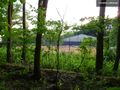
A view to the tennis court
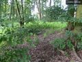
Geohash point


Achievements
Yakamoz earned the Land geohash achievement
|
Yakamoz has visited an Easy Geohash
|