Difference between revisions of "2013-07-19 53 9"
From Geohashing
imported>GeorgDerReisende |
imported>FippeBot m (Location) |
||
| (8 intermediate revisions by 2 users not shown) | |||
| Line 1: | Line 1: | ||
{{meetup graticule | {{meetup graticule | ||
| − | | lat= | + | | lat=53 |
| − | | lon= | + | | lon=9 |
| − | | date= | + | | date=2013-07-19 |
}} | }} | ||
| Line 9: | Line 9: | ||
== Location == | == Location == | ||
| − | + | It's a path near Fischerhude. | |
== Participants == | == Participants == | ||
| Line 20: | Line 20: | ||
== Expedition == | == Expedition == | ||
| − | + | ||
| + | I spent the night at a bench in the village Dannenberg near Bremen. From there I walked 7.8 km through the farming communities to the hash. Afterwards I went to Quelkhorn and from there I hitchhiked with ten cars home to Kassel. | ||
== Tracklog == | == Tracklog == | ||
| − | |||
== Photos == | == Photos == | ||
| − | |||
| − | |||
| − | |||
<gallery perrow="5"> | <gallery perrow="5"> | ||
| + | Image:2013-07-19 53 9 GeorgDerReisende 6853.jpg | here I spent the night | ||
| + | Image:2013-07-19 53 9 GeorgDerReisende 6892.jpg | on the way to the hash | ||
| + | Image:2013-07-19 53 9 GeorgDerReisende 6913.jpg | an arm of the river Wümme | ||
| + | Image:2013-07-19 53 9 GeorgDerReisende 6934.jpg | a reh near the hash | ||
| + | Image:2013-07-19 53 9 GeorgDerReisende 6938.jpg | so near! | ||
| + | Image:2013-07-19 53 9 GeorgDerReisende 6942.jpg | proof | ||
| + | Image:2013-07-19 53 9 GeorgDerReisende 6947.jpg | view to the north | ||
| + | Image:2013-07-19 53 9 GeorgDerReisende 6948.jpg | view to the west | ||
| + | Image:2013-07-19 53 9 GeorgDerReisende 6949.jpg | view to the south | ||
| + | Image:2013-07-19 53 9 GeorgDerReisende 6950.jpg | view to the east, to Fischerhude | ||
</gallery> | </gallery> | ||
== Achievements == | == Achievements == | ||
{{#vardefine:ribbonwidth|800px}} | {{#vardefine:ribbonwidth|800px}} | ||
| − | |||
| + | {{consecutive geohash | ||
| − | + | | count = 3 | |
| − | + | | latitude = 51 | |
| − | + | | longitude = 10 | |
| + | | date = 2013-07-17 | ||
| + | | name = GeorgDerReisende | ||
| − | + | }} | |
| − | |||
| − | |||
| − | |||
| − | + | {{Walk geohash | latitude = 53 | longitude = 9 | date = 2013-07-19 | name = GeorgDerReisende | distance = 10.8 km }} | |
| − | + | ||
| − | + | {{Minesweeper geohash | graticule = Hannover, Germany | ranknumber = 4 | n = true | nw = true | sw = true | se = true | name = GeorgDerReisende }} | |
| − | |||
| − | |||
| − | |||
| − | |||
| − | |||
| − | |||
| − | |||
| + | {{Minesweeper geohash | graticule = Hamburg (West), Germany | ranknumber = 2 | w = true | s = true | name = GeorgDerReisende }} | ||
| − | + | [[Category:Expeditions]] | |
| − | |||
| − | |||
| − | |||
| − | |||
| − | |||
| − | |||
| − | [[Category: | ||
| − | + | [[Category:Expeditions with photos]] | |
| − | |||
| − | |||
| − | |||
| − | [[Category: | ||
| − | + | [[Category:Coordinates reached]] | |
| + | {{location|DE|NI|VER}} | ||
Latest revision as of 03:14, 14 August 2019
| Fri 19 Jul 2013 in 53,9: 53.1108016, 9.0348685 geohashing.info google osm bing/os kml crox |
Location
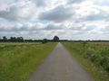
It's a path near Fischerhude.
Participants
Plans
Because it is so near to Bremen and 2013-07-18 53 8, I will spend the night in Bremen and then I want to visit the hash and then I want to hitchhike home.
Expedition
I spent the night at a bench in the village Dannenberg near Bremen. From there I walked 7.8 km through the farming communities to the hash. Afterwards I went to Quelkhorn and from there I hitchhiked with ten cars home to Kassel.
Tracklog
Photos
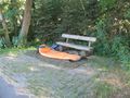
here I spent the night
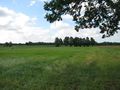
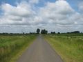
on the way to the hash
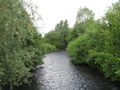
an arm of the river Wümme
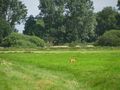
a reh near the hash
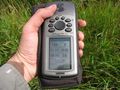
so near!
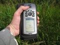
proof
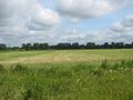
view to the north
view to the west
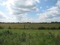
view to the south
view to the east, to Fischerhude


Achievements
GeorgDerReisende earned the Consecutive geohash achievement
|
GeorgDerReisende earned the Walk geohash Achievement
|
GeorgDerReisende achieved level 4 of the Minesweeper Geohash achievement
|
GeorgDerReisende achieved level 2 of the Minesweeper Geohash achievement
|