Difference between revisions of "2013-07-24 40 -111"
imported>Haberdasher m |
imported>FippeBot m (Location) |
||
| (2 intermediate revisions by one other user not shown) | |||
| Line 1: | Line 1: | ||
{{meetup graticule | {{meetup graticule | ||
| − | |||
| lat=40 | | lat=40 | ||
| lon=-111 | | lon=-111 | ||
| Line 22: | Line 21: | ||
== Expedition == | == Expedition == | ||
| − | This was a pretty easy hash to reach, all in all. The drive was a bit long, but pretty, and after a few mishaps in determining which parking lot was the correct one, we got there. My aunt had actually | + | This was a pretty easy hash to reach, all in all. The drive was a bit long, but pretty, and after a few mishaps in determining which parking lot was the correct one, we got there. My aunt had actually paid closer attention to the Google Maps rendition than I had and was able to identify the pole right next to the hashpoint, and from there the GPS dance didn't take long. My aunt and uncle seemed somewhat interested in the idea of geohashing, asking a fair amount of questions as to how it works, but my little cousin was less intrigued, admitting that she didn't understand why we were going to a random parking lot and that she considers it silly. Even though it was in an urban area parking lot, the mountains in the background still made this one of my prettiest hashpoints yet! |
== Pictures == | == Pictures == | ||
| Line 36: | Line 35: | ||
[[Category:Expeditions with photos]] | [[Category:Expeditions with photos]] | ||
[[Category:Coordinates reached]] | [[Category:Coordinates reached]] | ||
| + | {{location|US|UT|SL}} | ||
Latest revision as of 03:18, 14 August 2019
| Wed 24 Jul 2013 in Salt Lake City: 40.6099140, -111.8916063 geohashing.info google osm bing/os kml crox |
Location
In a parking lot in Midvale, UT.
Participants
- Haberdasher (plus relatives)
Plans
Hitting this one in the afternoon, since it's accessible and I want an excuse to go exploring in this graticule.
Expedition
This was a pretty easy hash to reach, all in all. The drive was a bit long, but pretty, and after a few mishaps in determining which parking lot was the correct one, we got there. My aunt had actually paid closer attention to the Google Maps rendition than I had and was able to identify the pole right next to the hashpoint, and from there the GPS dance didn't take long. My aunt and uncle seemed somewhat interested in the idea of geohashing, asking a fair amount of questions as to how it works, but my little cousin was less intrigued, admitting that she didn't understand why we were going to a random parking lot and that she considers it silly. Even though it was in an urban area parking lot, the mountains in the background still made this one of my prettiest hashpoints yet!
Pictures
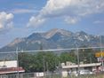
Mountain view
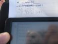
GPS

Stupid Grin


