Difference between revisions of "2013-07-27 49 8"
imported>GeorgDerReisende |
imported>FippeBot m (Location) |
||
| (3 intermediate revisions by 2 users not shown) | |||
| Line 20: | Line 20: | ||
the entrance to the cemetery. Look out for me! | the entrance to the cemetery. Look out for me! | ||
| − | + | == Expedition == | |
| + | |||
| + | Today I started to hitchhike from the autohof (truckstop) ''Lohfeldener Rüssel'' near Kassel. It was very hot. I waited there for more than two hours, then I got my lift. As we talked about my duty, the driver had been very interested in it. He had some time on his way, so he suggested to bring me to my destination. But then he tried to compute his built-in GPS-device, but I had the coordinates only with decimals, but his GPS accepted the coordinates only with minutes and seconds and we couldn't transform these. So he began to talk with his GPS: ''neues Ziel'', ''Adresse'', question ''welcher Ort'', ''Nauheim'', question ''welche Straße'', ''Friedhof'' — and the GPS-device gave him the correct address and I got a direct lift to the ''Waldfriedhof'' in Nauheim within two hours, arriving there at 15:23. | ||
| + | |||
| + | Arriving there, the driver asked me for what I have to do there and I showed it to him. So we both went to the point of the hash, following my instrument. The hash lay on an empty place of the cemetery near the southern fence. After looking around for some minutes he went off. I took the photos and did it too. Then I walked back to the entrance and sat there down on the bench and waited for other people to show, but no other geohasher arrived. | ||
| − | + | At about 16:30 I left the place for travelling to Ulm to see [[2013-07-28 48 9]]. | |
| − | |||
== Tracklog == | == Tracklog == | ||
| − | |||
== Photos == | == Photos == | ||
| − | |||
| − | |||
| − | |||
<gallery perrow="5"> | <gallery perrow="5"> | ||
| + | Image:2013-07-27 49 8 GeorgDerReisende 7207.jpg | near for proof | ||
| + | Image:2013-07-27 49 8 GeorgDerReisende 7208.jpg | coordinates for proof | ||
| + | Image:2013-07-27 49 8 GeorgDerReisende 7209.jpg | that's me at the hash | ||
| + | Image:2013-07-27 49 8 GeorgDerReisende 7211.jpg | view to the east | ||
| + | Image:2013-07-27 49 8 GeorgDerReisende 7212.jpg | view to the north | ||
| + | Image:2013-07-27 49 8 GeorgDerReisende 7214.jpg | view to the southwest | ||
| + | Image:2013-07-27 49 8 GeorgDerReisende 7225.jpg | the entrance to the ''Waldfriedhof'' | ||
| + | Image:2013-07-27 49 8 GeorgDerReisende 7230.jpg | the ''Königstädter Straße'' passing the cemetery | ||
| + | Image:2013-07-27 49 8 GeorgDerReisende 7234.jpg | the internet was here! | ||
</gallery> | </gallery> | ||
== Achievements == | == Achievements == | ||
{{#vardefine:ribbonwidth|800px}} | {{#vardefine:ribbonwidth|800px}} | ||
| − | |||
| + | {{Thumbs Up | latitude = 49 | longitude = 8 | date = 2013-07-27 | name = GeorgDerReisende }} | ||
| − | + | {{xkcd-100 | latitude = 49 | longitude = 8 | date = 2013-07-27 | distance = 218 km or 136 mi | name = GeorgDerReisende }} | |
| − | + | ||
| − | + | {{drag-along | latitude = 49 | longitude = 8 | date = 2013-07-27 | name = GeorgDerReisende }} | |
| − | |||
| − | |||
| − | |||
| − | |||
| − | |||
[[Category:Expeditions]] | [[Category:Expeditions]] | ||
| − | + | ||
[[Category:Expeditions with photos]] | [[Category:Expeditions with photos]] | ||
| − | + | ||
| − | |||
| − | |||
| − | |||
| − | |||
[[Category:Coordinates reached]] | [[Category:Coordinates reached]] | ||
| − | + | {{location|DE|HE|GG}} | |
| − | |||
| − | |||
| − | |||
| − | |||
| − | |||
| − | |||
| − | |||
| − | |||
| − | |||
| − | |||
| − | |||
| − | |||
| − | |||
| − | |||
| − | |||
| − | |||
| − | |||
Latest revision as of 03:20, 14 August 2019
| Sat 27 Jul 2013 in 49,8: 49.9516838, 8.4488184 geohashing.info google osm bing/os kml crox |
Location
The hash lies on the cemetery Waldfriedhof of Nauheim, county Groß-Gerau.
Participants
Plans
As today is Saturday, it would a good place for an official xkcd meetup. But I think, a cemetery is not a good place for such a meetup, so I propose beside the entrance to the cemetery. Look out for me!
Expedition
Today I started to hitchhike from the autohof (truckstop) Lohfeldener Rüssel near Kassel. It was very hot. I waited there for more than two hours, then I got my lift. As we talked about my duty, the driver had been very interested in it. He had some time on his way, so he suggested to bring me to my destination. But then he tried to compute his built-in GPS-device, but I had the coordinates only with decimals, but his GPS accepted the coordinates only with minutes and seconds and we couldn't transform these. So he began to talk with his GPS: neues Ziel, Adresse, question welcher Ort, Nauheim, question welche Straße, Friedhof — and the GPS-device gave him the correct address and I got a direct lift to the Waldfriedhof in Nauheim within two hours, arriving there at 15:23.
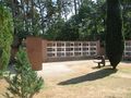
Arriving there, the driver asked me for what I have to do there and I showed it to him. So we both went to the point of the hash, following my instrument. The hash lay on an empty place of the cemetery near the southern fence. After looking around for some minutes he went off. I took the photos and did it too. Then I walked back to the entrance and sat there down on the bench and waited for other people to show, but no other geohasher arrived.
At about 16:30 I left the place for travelling to Ulm to see 2013-07-28 48 9.
Tracklog
Photos
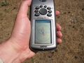
near for proof
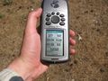
coordinates for proof
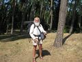
that's me at the hash
view to the east
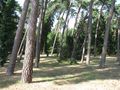
view to the north
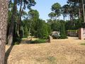
view to the southwest
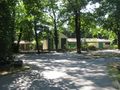
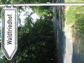
the entrance to the Waldfriedhof
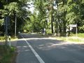
the Königstädter Straße passing the cemetery
the internet was here!


Achievements
GeorgDerReisende earned the Thumbs Up Geohash Achievement
|
GeorgDerReisende earned the XKCD-100 Achievement
|
GeorgDerReisende earned the Drag-along achievement
|